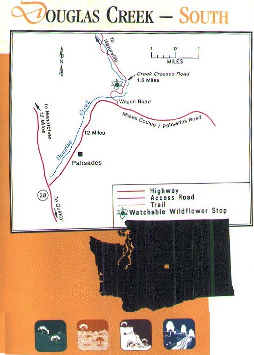
Follow Highway 28 to Palisades Road and then turn left onto graveled Wagon Road and drive 1.5 miles. Park at one of the pullouts before the creek. The wilflower viewing area includes the slopes and the ridge to the left of the road. Note: Do not attempt to drive across Douglas Creek, as it is much deeper than it appears. To access the other side of the creek, follow directions for visiting Douglas Creek-North |
Douglas Creek uplands - John Marshall
Douglas Creek is one of the few perennial (flowing year round) creeks in the Columbia Basin. This segment flows through a deep canyon, carving cliffs in the iron-rich basalt layers left by ancient lave flows. At the base of the cliffs, serviceberry (Amelancier alnifolia), squaw currant (Ribes cereum), mock orange (Philadelphus lewisii) and purple sage (Salvia dorrii) have anchored themselves in areas of loosely fractured rock, or talus. Hike up the slope through low-growing plants that thrive in spite of the extreme weather. From the ridge, enjoy grand views of Douglas County and Moses Coulee. Wildflower viewing opportunities are spectacular from early April to mid-June, when a flush of flowers spreads fromm the deep, moist soils of the shrub-steppe slopes to the shallow, drier soils of the ridgetop lithosol. Unlike nearby Moses Coulee, which was formed by the sudden overwhelming force of the Spokane Floods (see In the Beginning), Douglas Creek was channeled over thousands of years by the ice and snow melt from nearby Badger Mountain. Springs continue to feed the creek today, as it cascades in and out of a dozen shim- mering sandstone pools on its way down through Moses Coulee to the Columbia River. To explore riparian plant communities along a more easily followed trail, use the douglas Creek - North Watchable Wildflower site information.
A half-hour climb up the slope and along the ridgetop will lead you past a few of the five varieties of desert buckwheat (Eriogonum spp.) found here. Important dominants of the shrub-steppe, desert buckwheats are low rounded shrubs with numerous tiny flowers clustered at the tips of upright branches. The yellow or white flowers turn pink to rose-red as the plant |
