Camping
in Washington
 "Follow
the road less travelled....",
well that's what the camp books suggested,
but I don't think there can be such a thing in the middle of summer, on
this vast continent. Setting out Sunday morning, we followed the Okanagan
Lake passed Kelowna, Peachland, Summerland and finally to Penticton (over
90 miles!)....this is stone fruit season, and the orchards are brimming
with produce sold by the roadside in fruit markets or available as "pick-your-own"......cherries,
plums, peaches, apricots and apples (the kids were starting to look like
fruit!).
"Follow
the road less travelled....",
well that's what the camp books suggested,
but I don't think there can be such a thing in the middle of summer, on
this vast continent. Setting out Sunday morning, we followed the Okanagan
Lake passed Kelowna, Peachland, Summerland and finally to Penticton (over
90 miles!)....this is stone fruit season, and the orchards are brimming
with produce sold by the roadside in fruit markets or available as "pick-your-own"......cherries,
plums, peaches, apricots and apples (the kids were starting to look like
fruit!).
We stopped for a break
at Skaha Lake, just the other side of Penticton. A very picturesque lake
packed full of campers enjoying every water sport (short of surfing, that
is). A large canal joins the two lakes through Penticton and adventurous
souls jump on a tube and float for several miles downstream where a bus
will pick them up and take them back to the beginning!! There's no shade,
so sunscreen, hats and shirts are a must, as the journey is slow and very
laid back...
Crossing the U.S. /Canadian
border, we purchased visas from some very, um.... er, (shall we politely
say) official-looking customs officers, then stopped at the nearest lake
(Osoyoos Lake at the town of Oroville) for a picnic lunch and for the boys
to have a swim. The lake was cool but the air temp. by now was around 28C.
Right about now you have to start thinking Fahrenheit not Celsius, miles
not kilometers, and pounds and ounces not kilos and grams....not to mention
doing a bit of arithmetic to see that you can't buy much with an Aussie
dollar!
Our first day's journey
ended at Coulee Dam. As the greater area of eastern Washington is quite
arid, much of the Columbia Basin is irrigated from the waters of Lakes
Roosevelt and Banks. Consequently it also supplies hydroelectricity and
a fabulous recreation playground for those who enjoy water sports (and
who doesn't?). Grand
Coulee Dam has the largest laser light show in the world. Our campsite
was called Spring Canyon; as we were in the middle of the Fourth of July
long weekend it was well,... packed. We squeezed in between an RV and another
tent, thanks to the generosity of "Jim" and his dachshund. ...and were
promptly given the sage advice of our neighbour "there be rattlesnakes
in them bushes, got a snake-bite kit in the car if you need it".....the
snakes weren't to be seen or heard, but the prickly cactus has four inch
spikes that imbed themselves nice and smoothly, but pulling them out is
quite a different story...("here, I'll pull it out for you Mum, promise
you wont feel a thing").
We awoke to a light sprinkling
of rain, packed our gear after a hasty breakfast, and headed south along
155. The terrain is mostly semi-arid, tree-less plateaux dotted with prickly
brush, plunging into vast canyons and water carved gorges....the various
rock formations are a geologists dream. We stood on the edge of waterfall
3.5 miles wide and plunging 400 feet .....well, it was a few thousand years
ago...now they call it the Dry Falls and the terrain is still spectacular
minus the water. We passed by Soap lake, reputed by Indians to have wonderful
healing properties....it is heavily laden with minerals, tourists from
all over the world swear by it. We drove through Moses Lakes, a comparatively
tiny town with a population of 11,000 but with its own international airport!!
We stopped at Vantage
on the Columbia River. A town that is apparently known for its petrified
Gingko Forest. The only known one in existence, the wood was entombed in
lava ,over 15 million years ago. Vantage, seemingly miles from anywhere,
also plays host to rock concerts (that's rock as in music, not as in geology)....the
concerts are held in a natural amphitheater, a gorge...the night we were
there, Motley Crue were playing, in the following days they were being
entertained by k.d.Lang, Sting, The Who, Counting Crows, Bob Dylan and
the Red Hot Chili Peppers...it was really bizarre if you could see the
setting....the mighty Columbia River makes an awesome backdrop. Riverstone
campgrounds were quite picturesque (and with a heated indoor pool we weren't
exactly roughing it yet) but the ceaseless wind was rather trying...even
the local restaurant is called "Blustery".
Next day we had breakfast
on the banks of the Columbia river (Fourth of July...people selling fireworks
in stalls all along the roadside). We passed through many towns on our
way to the Oregon border, but missed every parade!! (It was rather hot,
and parades weren't on our list of priorities). Plains and prairies soon
opened out into vast agricultural valleys....Yakima (yack-ee-ma) has 82
wineries in the surrounding area, not to mention orchards and crops. Looking
down over the town, the valley is a giant patchwork quilt of fertile farmland,
and in the distance the snow-capped peaks of Mount St.Helens and Mount
Adams rise above the valley floor. Driving through the Klickitat (say it
fast!) both sides of the highway are Indian Nation Reserve, covering an
area of more than a million acres.
As we approached the Columbia
River again (on its meandering course) which also signifies the border,
the vegetation abruptly changes from arid to pine forests. Our day's end
is at Maryhill campground. Like many State parks, this one is well maintained,
with irrigated lawns. We had a campfire next to the river, watched a paddle
steamer pass, and waited for the fourth of July hoopla, but it never eventuated...had
a restful night's sleep...next day we watched the wind surfers speeding
along the river (the wind was several knots) but the current was way too
swift for swimming...we drove up to Stonehenge built as a war memorial
by Sam Hill in the '20s...the view of the river was spectacular.
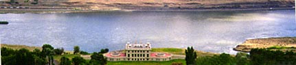
Maryhill Museum on the Columbia River
The next day we crossed
into Oregon.....and that's another page of the story......
A month later we were on
our way home travelling west of the Cascade Ranges. We left Seaside(Oregon)
after a wander along the boardwalk and a peek at various galleries and
shops....unique sculptures, local art and delicious homemade chocolate
fudge...the boys had a ride on the carousel and a play on the beach(very
wide, clean sand, despite picnickers being allowed to light fires right
on the beach). We thought the Columbia river was wide in Maryhill; when
it finally reaches the sea, it is several miles wide....the bridge
at Astoria was the longest and probably the tallest we had ever traversed...the
kids were momentarily awestruck (alas,it was a very fleeting moment)

Astoria Bridge
We
then headed north-east through Olympia, Tacoma and around the outskirts
of Seattle along Puget Sound...it is whale watching season here, and pods
of orcas can be seen around Anacortes
in the warmer months...(we didn't get time to travel that part of the coast,
but I hear the Olympia National Park is spectacular). We diverted from
the I5 about dinner-time to avoid the peak hour traffic and grab a bite
to eat.....we were feeling less inclined to pitching the tent and more
inclined to finding a motel for the night.....but it was Friday night and
what on earth were we thinking....no room at the inn...thats for sure!!
Camp grounds all full, even the luxury ones....night fell and we were still
driving east, and were fast approaching the National
Cascades Park when Richard spied a camp ground. The gracious host found
us the last spot vacant and then kindly offered us a tepee....the kids
were ecstatic about sleeping in a real Indian Teepee, Mum and Dad were
ecstatic about not having to put up the tent at 10 o'clock at night....zzzzzzzzzzzblissssssssss.
(Teepees, cabins, yurts, houseboats and even covered wagons, are available
all over Washington and Oregon if you don't feel like pitching the tent....the
teepees even have carpet on the floor!!)
Early
to rise the next day, we followed the picturesque Skagit River...a vibrant
peppermint green colour from the minerals washed down from the Cascades.
We stopped at the Visitors centre to the park which had an excellent interpretive
display, complete with audio-visual shows and hands-on activities for the
kids, trails through the forest were boardwalks with hand-rails.....like
this one, and most State and National Park facilities, there is a great
emphasis on wheel-chair friendly accessibility.
From
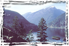
here we had an excellent birds eye view of the Cascade Range.

Cascade
Mountains
We
stopped at Diablo Dam with that astonishing green colour (much like the
green in the background of this page) and just further north, Ross Dam,
which was deep blue. When Ross Dam was built it flooded an old gold mining
city....the ruins lie fathoms beneath the cold blue waves.
Ross Dam
We
picnicked in a sandy cove of one of the feeder streams for the Dam. The
boys stripped off and paddled in the icy mountain water...the air temp.
was mid 20s
As
soon as we crossed the Washington pass to the east side the terrain and
temp. abruptly changed. Before long we were in the mid 30s and once again
all the camp grounds were full (and hot and dusty). We passed through the
quaint town of Winthrop,
an authentic Wild West town, the little town of Twisp and then after much
indecision by mum, we decide upon a very quiet camp-ground called Loup
Loup...there were no other children, but the hosts had two huge Irish wolfhounds
and our nearest neighbours had dachshunds, so the boys were happy. No bears
in this camp, but we did see a beautiful doe in the early evening and again
in the morning. The hosts said cougars often wander around the camp at
night but they don't usually bother anyone....thats so reassuring......it
was the quietest, mostly relaxing camp we had been in...we toasted marshmallows
after dinner, watching the moon come up over the horizon...I could hardly
keep my eyes open...zzzzzzzzzzzz
That
was our very last camp site...we were back in Vernon by noon!! The landscape
had browned a bit in the summer sun, and the little township of Tonasket
(south of the border) had suffered bush fires, the few pines scattered
on the hills were charred. We have since heard just how devastating the
fires have been, and saddened to know that some of the pristine forests
and breath-taking panoramas we witnessed just weeks ago, are now in ashes.
According to the Forestry department, campers are not responsible for the
majority of the fires this year, most have been from lightning strikes...and
in some way it is some compensation to know it is a natural process, and
re-generation is inevitable.
Next page