Les Gres d'Annot
(Annot Sandstone)
 A view of Annot and the cliffs behind. Most of the developed climbing takes place
on the boulders in the wood on the far right-hand side of this picture. The highest
line of cliffs you can see in this picture has just two routes on it (F8a and F8c, since you ask).
A view of Annot and the cliffs behind. Most of the developed climbing takes place
on the boulders in the wood on the far right-hand side of this picture. The highest
line of cliffs you can see in this picture has just two routes on it (F8a and F8c, since you ask). |
Click here for route info and photos
Aspect and climate
As with the rest of Provence, the best time to go for serious climbing is Sept-Nov or Mar-Apr, before it gets too hot in the summer
or too wet in the winter. It can be rainy in April, but as most of the boulders are free standing, drainage is not an issue, and
some harder routes stay dry in all but a downpour. All the climbing is on the north side of the valley and so gets plenty of sun when it's out,
but there is always escape from it.
 Getting there and accommodation
Flights to Marseille can be as cheap as Ł50, from which a 3 hour drive will see you at the crag. Nice is closer, only about 1.5 hours away.
Annot is well served by rail links, and all the crags are within easy walking distance of the town. There is a camping and caravan site
within the town on the main road (D908 - towards Colmars & Barcellonnette), and many hotels which only seem to open Apr-Sep.
Self-catering studios are available in Les Scaffarels (1km from Annot) courtesy of the very friendly Mme and M. Limbertie
(Tel: 04.92.83.25.27) and come highly reccommended!
Click here for the MultiMap location of Annot.
Other information
The local topo is available from Cafe du Commerce in the main square, or from the climbing shop La Degaine (Tel: 04.92.83.35.02)
which has all the usual supplies. There is an EcoMarche supermarket just north of Annot which shuts at 7pm, and the usual collection of boulangeries, bars, etc.
within Annot itself, and a tourist information center in the main square.
Links
Grimp d'Azur - where we first found out about this place. Has details of other local climbing including the steep limestone gorge crag in Les Scaffarels (F7b-8c).
Annot website - local site for tourism, etc.
More Annot climbing photos from Bernard Cocatrix
|

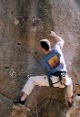
La Nez F6a+
Le visage boulder
|
|
Introduction
Annot, within the Haute-Luberon region of Provence, is something of a geological oddity: an impressive collection of sandstone cliffs and
boulders amongst all that limestone (the Verdon is only about 30 minutes drive away).
Though most of the developed climbing is on the boulders in the woods above the railway station, the routes are usually 15-20 metres high and are, shall we say, 'action packed'.
The climbs follow strong lines usually, and are reminiscent of The County, and the harder bits of High Rocks bizzarrely. There are four marked bouldering circuits if you haven't had quite enough.
All the boulders are situated in delightful woodland full of the usual flora and fauna. Pretty child-friendly too, as the number of families taking picnics there testifies.
|

Verseau F7a+, Le Zodiaque boulders
|
The routes
 There are many fine quality routes, taking slabs, aretes and overhanging faces on pockets. All are very well bolted with large staple such
as those found at Buoux. The one downside to the place is the amount of holds that have been created. Given that, they have been done in a very
sympathetic way to the rock and it may take you some time to realise the Buoux-like pocket you're stuffing your fingers into is a 'work of art'.
There are many fine quality routes, taking slabs, aretes and overhanging faces on pockets. All are very well bolted with large staple such
as those found at Buoux. The one downside to the place is the amount of holds that have been created. Given that, they have been done in a very
sympathetic way to the rock and it may take you some time to realise the Buoux-like pocket you're stuffing your fingers into is a 'work of art'.
This doesn't detract from the climbing, but it is annoying the lack of imagination the developers of the crag have: all the hard routes
established are 'manufactured' from blank overhanging faces, while there are many technically hard routes to do on the numerous aretes
and slabs that lie forgotten. It's as if the locals don't realise what good footwork and friction can achieve. Anyway, suffice to say that the
potential for new routes is staggering and that (hopefully) these will be developed in a more ethical way.
|
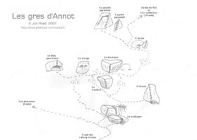 |
Les Secteurs
Click on the map to the left or here for more details and photos of routes
and a map of the boulders. |
Acknowledgements
Thanks to Jonny Clark and Caroline McIntyre for the holiday, translational services and belaying duties. Gallagher for his Gri-Gri - you left it in my rucksac mate - whoops! Bernard Cocatrix and Christophe Bordieu for feedback and correcting the map for me. Cheers!
| |