Carelton River
Tusket Islands

|
Tusket
River Carelton River Tusket Islands |
||
|
|||
Carleton River, Digby/Yarmouth County, Nova Scotia
How to get there
One of the most scenic rivers in Yarmouth County, this river offers a broad variety of river types. From quiet meandering river to challenging runs and everything in between. Starting in Digby County at Wentworth Lake Pocket Wilderness, located on highway 340 north 45 kilometers out of Yarmouth.
Carelton River Map
Carelton Community Center's annual Poker Rally
Each year the Forest Glenn Community Center holds a poker rally to raise funds for their local community hall. Usually around the first weekend in May when the water is still cold and high from spring run-off. The rally starts at around 9:00 am at the Wentworth Lake Pocket Wilderness where you are given a large garbage bag to store all your garbage. It is also encouraged to pick up any other garbage you might see floating along the way. Also a small plastic bag to hold your score card for the poker run. At designated points along the river you draw from a deck of cards, one card per stop and at the end of the rally the person with the highest poker hand wins the first place prize. Usually a prime piece of outdoor camping or canoeing equipment as well as a finely crafted trophy to take home and put up on your mantel or TV. There are also a series of draws from a hat that might fetch you a smaller prize, a little memento of your trip. There are plenty of prizes and also a dinner at the end of the run at the Forest Glenn Community Center, cooked by the good people of the community. All this and a ton of fun for $10.00. per person. A better deal you'd be hard pressed to find anywhere.
Carelton River.... What a delight!
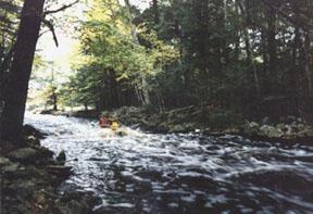
Upon entering Wentworth Lake you head south east to the far shore to the first check point which is at a dam. Depending on the water level you could run the dam if you wish but it is generally not a good idea as dams are man made objects and therefore span the whole width of the river and making an escape route impossible should you tip at the bottom. A potentially dangerous and lethal predicament to be in. Not a good way to start the day. The dam is easily portaged and my advice is to do so. There are broken timbers with large canoe eating spikes along the top just below water level just waiting for the unsuspecting paddler. From here on in the river is swift flowing and has many good rapids, most of which can be run by even novice paddlers. The first rapid after the dam is a long one about 150 yards long which is probably one of the most difficult on this run. The best way to run this rapid is down the middle of the river till you get to the sharp bend to the left. Here is the hard part. The river will want to take you into the shore on the right but the only problem with that is that there are very large trees that line the shore with their branches hanging over the river about chest height. So the object of this game is to keep as far left as possible around the bend. Not an easy task as there are a series of large diagonal waves working against you. The best rule is to get out and scout the run before you run it unless you have an experienced guide to take you on this river.
The Carelton flows through some of the most beautiful wood land in Yarmouth County although along the way you will notice the clear cutting that takes place and come to realize the stupidity of such types of wood harvesting. The banks of the river are very sandy and because of this there are many sweepers (trees that have fallen into the river with the branches in the water) making navigation a little tricky at times. Care must be taken when approaching bends in the river, of which there are many, as sweepers are a dangerous obstacle. Being caught in one is no picnic. If you should by chance tip and find yourself heading for one you must swim on your belly with your hands ready to catch a branch and lift yourself up onto the tree. Failure to do so could result in disaster. The river bottom is mostly gravel making this a superior site for spawning fish, mainly brown and brook trout and the odd salmon. Bring your fishing rod as this river will offer you plenty of spots to fish. The neat thing about this river is when it bends at a great angle there is almost always a deep depression in the outside part of the bend with a small upstream brook at the top of the bend, these are some of the best fishing holes on the river. Further along the river you will encounter "Logan's Run". Here is where everyone gathers for lunch break and watch as people try to navigate the run without getting wet. A formidable task for most because many have imbibed since the start of the rally and are not in the best frame of mind to do the quick maneuvering required to successfully navigate this run.
Further down river there is hot coffee, tea and hot chocolate, doughnuts and chips for a snack. A fire is usually on the go to dry out the wet ones and to warm your cold toosh by. A few more rapids and the river eventually slows down and meanders through some agricultural land. It twists and turns for about 3 miles until yo reach the top of Parr Lake. Here the wind is usually against you as you paddle your tired and aching body
2 1/2 miles to the Forest Glenn Community Center for a hot supper and to collect your prize. The rally ends at 4:00 PM and that is when all poker hands are tallied up and the winner is announced. This rally has been held for the past twelve years of which I have only missed three and is a great place to meet new friends and old ones to. If you're here for the Rally or any other time this is one of my favorite rivers to paddle. You don't have to stop at Parr Lake though. You can keep on going down river a few more miles to the small rural Community of Carleton. Along the way you will come to "The Gulch". An awesome section of river about 1 km long with sheer cliff on either side. One false move here and it's a long swim to the end in some very heavy water. Easily a class three rapid it is one of the most difficult runs on this river and must be scouted before running.
|
|
| Page
design By 2000 |
© |
|
| Sign
Guestbook View Guestbook |
Welcome to Possum Lodge Canoe Tripping page. By clicking on the links at the top of this page you will read of my experiences on the rivers and lakes of the Tusket River Basin. Detailed descriptions of how to get to each river or lake as well as what kinds of obstacles you may find along the way such as, portages', rapids, natural obstacles and man made obstacles. Points of interest and a little history to make your virtual trip a little more complete and the odd picture sprinkled in for good measure. So those of you who have graphics turned off on your browser...... turn em on 'cause you'll be missing some of the nicest scenery South Western Nova Scotia has to offer.
| Page
design By 2000 |
© |
|
| Sign
Guestbook View Guestbook |
Tusket River, Yarmouth County, Nova Scotia
Glad you could make it! This is a description of the Tusket River in Yarmouth county. It's the river just outside my front door, well actually the Quinan River is just out my front door but it meets with the Tusket about 200 yards down stream. This river has class 3 rapids dispersed along the route from Kemptville through to Tusket. Depending on river levels sometimes even class 4 rapids. It's navigable from early spring till December as we don't get freezing weather till mid December. So for all you white water fanatics and kooks who would rather be floating in freezing cold water than spending the afternoon home, cuddled up with a nice hot cup of coffee or cold a beer, watching football or other such late fall sport, this is the river for you. The best water can be found early spring (March) till mid June then from October till freeze over in December. Tusket River map click here This route could take you as long as 3 1/2 days or 5 hours depending on your schedule. There are take-out spots at various points along the river. In this trip we start off at the bridge in Kemptville and end up in Tusket by the Nova Scotia Power Corporation dam.
How to get to East Kmptville
Take highway 101 west to the Hebron exit ant then turn right on to the 340. Take the 340 to Carleton then turn right in carleton and follow the sign to Kemptville. Bear right at the fork in the road and the bridge is just a couple hundred yards away. You can see it at the fork. There is a large clearing at the top of the hill just before the bridge where you can park your vehicle. (Don't forget to lock your doors! This may be a small community but there is always someone who has nothing better to do than to screw up your day.) Oh yeah... almost forgot. Try to have a spare set of keys with someone you know who will not be going on your trip and make sure you can reach them if you need to. How many times has someone gone canoeing and ended up scoping for trout and lose their car keys in the process?
Start point.
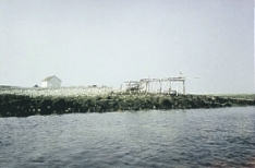
Pearl lake is a small lake, about 2km long with cottages, farm land and hardwood ridge on the east side and softwood forest on the west. About halfway down the lake on your right you will meet the Tusket river. The Tusket is a small narrow river never getting much wider than 10 or 15 yards at its' widest until after the dam in Tusket where the river runs to the Atlantic. Then it can get as wide as 1/2 mile. Made up of numerous rapids and riffles and eel weirs dotting its' entire length the Tusket river challenges you with Rapids that have names like "The Pulp Chute", "The Bad Pitch, aka. "Hemlock Falls", Les Rapid Sauvage, Grid Iron Rapid and Long Falls. Please make sure you take an extra garbage bag with you to pack out all your garbage. The Tusket River Valley is a protected environmental area with a few endangered and rare flora as well as the home of a host of hinterland creatures. You wouldn't want anyone to come into your home and chuck candy wrappers or beer bottles around your living room, well the same goes for us in their home. Low impact camping practices apply on day trips as well as overnight and longer trips. For a list of environmentally friendly camping tips you are invited to visit my camping page.
 "Seven Branches, The Pulp Chute" |
About 2km down river you will come to a place called "Seven Branches" or "The Pulp Chute" as it is known by the locals. This was where a large island in the middle of the river obstructed the passage of pulp wood down stream and was literally split in two. A channel was dug to let the logs flow un- impeded down river to the various saw mills that lined the river. A narrow channel about 25 feet wide runs down the middle of this small island. It has large softwood growth on both sides and the branches form a pale green canopy overhead as you shoot the 100 yard channel. About half way down the chute is a small ledge of about 2 1/2 to 3 feet high creating a small hole. The end of the run has a series of standing waves just waiting to swamp your boat if you've taken on to much water at the hole. The hole is a perfect place to practice surfing or riding, if you have the nerve. It is just wide enough for a 17 foot canoe but you have to be quick to catch the eddy on river right in order to play there. If you dump it's a short swim to the bottom of the run which empties into a pool. A fire pit can be found on river right at the bottom of the run, a great place to break for lunch. For the not so experienced canoeist you can portage this run on river right where there is a very good path. After this there is a 4 km paddle to "Hemlock Run, aka: The Bad Pitch."
Now here is where you would be best to get out and scout your escape routes. Once again the portage is on river right but the path is not nearly as nice as the previous one at the Pulp Chute. There are a couple of bail out spots in this run but if you miss them be prepared for a wild ride. Sharp turns and then a steep ledge, about 6 foot drop in a 30 yard length, ending with a rooster tail and three to five hay stacks, depending on river levels, just waiting to swallow you whole. No place for air braces or gunwale braces here. Many a cedar strip, canvas and fiberglass canoe have gone to the great pond in the sky here. This is definitely a class 3 rapid and a class 4 at high water. The run gets split in two about 3/4 the way down. Now to some the left will look more challenging but I would advise against it. At high water it's just to dangerous and at low water it's just to damn bony, even for plastic canoes. Now you kayakers out there might have a better go of it than canoeists.
An awesome place to play, the first ledge below The Bad Pitch. It would be advisable to set up at least two rescue spots with throw ropes along this rapid as well as one at the very end. Also a couple of canoes waiting below to rescue swimmers and gear as this could be a swim they wouldn't want to do twice. Trust me... I've done it once and am not to keen on doing it again. Along river right about 100 yards or so is a clearing suitable to set camp. You could stay and play here for the rest of the day or you could travel on to Quinan which is about another 3 hour paddle. After the Bad Pitch is a series of level 1 rapids and a short paddle to Third Lake.
 "A ledge about 10 minute paddle down river from "The Bad Pitch"" |
Third Lake is a tricky lake to get out of if you don't have a map. First off you should always have a map no matter how simple the run. Remember! Murphy's Law will always apply. When you enter Third Lake keep left. If the island is on your left as you pass you're out to far. Keep between the island and the left hand shore. Past the big cove , the river continues on from there. By all means if you wish to explore the lake go ahead. About a 15-20 minute paddle and you will enter Gillfillan Lake. Keep a sharp look out for an osprey that has her nest along the lake shore. They're such a magnificent bird but tend to be disturbed easily so don't hang around if you see her hovering and squawking. Gillfillan Lake can be quite a difficult paddle if the wind is against you, which seems to be the case almost every time I've paddled it. The wind can beat up white caps in no time flat and with a fully loaded canoe and two adult paddlers, they could have a hard time of it. Three miles of hard paddling lie ahead here. The river is about 3/4 the way down on the right and has a good little rapid right off the start. From here on down you will encounter more and more eel weirs made of stone. These were used for trapping eels for salting. They are long lines of stones built into a wall that converge in the middle of the river where a trap fashioned out of spruce branches and fish netting would be wedged in the small opening that pointed down stream. Most all haven't been used for trapping eels for many years but some have been used to scoop kayak. A small bony fish otherwise known as "Gaspereau" or I believe in Ontario they call them "Moon Eye". Anyway they use large nets that look like very big dip nets and as the Gaspereau come down stream people stand on the rock walls and scoop them with this net. Sometimes the handle breaks under the weight of the catch, as much as 100 or more fish about 1lb or a little better in one scoop. Hah!! Take that to the bank Post Raisin Bran with your "two scoops of raisins!" Between Gillfillan Lake and Lac d'Ecole or School Lake is a level 1 rapid known as "Les Rapid Sauvage". The Tusket River Valley was home to the native MigMaq Indians long before the Europeans came here in 1605. Head left down the lake and on the opposite side the river continues with a series of rapids and weirs that if you go straight through will only take you 8 minutes to run, (although I don't know why anyone would want to as this is the best spot to play on the whole river as the road runs all along it to Quinan.) If you dump and get to wet and cold, help is only a few yards away.
In Quinan you could stop here and come on over for a visit. Just ask anyone at the houses at the bridge where I live. It's a small village and everyone knows just about everyone here,or keep going down stream to another camp site called Duncason's Island. If you need supplies you can get them in the village. We have a small convenience store as well as an outfitter. Spring-Haven Canoe Outfitters is owned by Larry Muise, a very good friend of mine and you can get in touch with him via the Spring-Haven Canoe Outfitters page. Duncason's Island is a well used camp spot and as a result we have had to move the fire pit further to the center of the island as the tree roots were well out of the ground due to high traffic mixed with high water in the spring. Because of the safety factor it became to dangerous to use. It was only a matter of time before someone would stumble and hit their head on the rocks of the fire pit. This is the only camp site used to this extent along the river. It is used by school kids and the local canoe club for family camp trips and fishing trips. Normally we try to instill 'low impact camping" but it seems in this case where it has been used by so many for so long we're a bit to late. A nice spot all the same. Further along we come to "Grid Iron Rapid". It is relatively short but a rush just the same. Keeping to the right side of the run is the safest route and here again a farm is located at the bottom of the run if you wish to take out here. Now comes another hard paddle if the wind is not in your favor. Three miles of dead water till you reach the Canaan bridge. This stretch of river is a haven for black ducks , golden eye and mallards and Great Blue Heron as well as the odd beaver. Lodges can be seen doting the shores. You can also take out at the Canaan bridge if you wish or go on to Wilson's Lake. It is along this lake shore where your chances of finding the Pink Coreopsis, the Water pennywart and the Plymouth Gentian. All rare and endangered species of coastal plain flora native only in the Tusket River valley and Kejimikujik National Park in the center of the province.
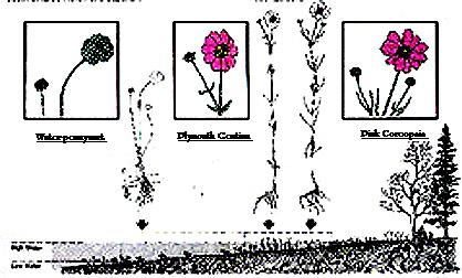 Water -pennywart, Plymouth Gentian and Pink Coreopsis |
The nearest place you'll find these plants is at Cape Hatteras in the United States. Water -pennywart, Plymouth Gentian and Pink Coreopsis. Three of the endangered rare plants of the Tusket River Valley. Upon entering Wilson's Lake head due west, across to the other shore and the entrance to the river is on the left of the large island. Behind the island on river left is another nice clean spot to have lunch or set camp if you desire. It has a fire pit and there can be plenty of firewood to be found lying about. It is preferable to use branches that have fallen from the wind for fire wood and we ask that you not break or cut any limbs or trees. Also, please do not use birch bark for starter. The small rapid to follow is known as Cavanaugh's Run. This run leads into Bennet's Lake. Bear left in Bennet's and go down to the end. Round the bend there is a long set of rapids with a couple of ledges spanning the width making for some nice souse holes to surf and ride. This is known to the locals as "Long Falls". At the end of this run on the left is a field known as "Ghoules". This is privately owned and permission should be obtained from the owners if you wish to make camp here.
Larry Muise at Spring-Haven Canoe Outfitting can put you in touch with the owners.
About 10 minutes more paddling will bring you to "King's Lake". When entering King's Lake paddle straight across and into "Gavel's Lake". There is a peninsula on the right side near the top of the lake. From the water it doesn't look like much of a camp spot but upon closer inspection, this means get out and walk in a little ways, you will find one of the few Virgin stands of timber in Yarmouth county. There is a large swamp between here and the road which makes it more trouble than it's worth to get the wood, so it has never been logged. The size of the birch and beech trees here are quite impressive making for a majestic wood stand. On one occasion I had to camp here we were a group of 24 people. Of course this many canoes draw attention and the owners came over in their power boat to check out and see who were all these people using their land. Circumstances were that we had not been able to contact them before hand to get permission to camp. See my Canoe Touring Class Page for that story. When we explained who we were and what we were doing there they were much more comfortable with the situation and they sat and talked and had some good ol' cowboy coffee with us around the fire. When we left the next morning I was in charge of sweeping the camp for forgotten articles and litter, and to tell you the truth, I walked right by the spot where we had the fire pit and you could not tell that anyone had been there. More on how we achieved this can be found on my
camping hints page.
After Gavel's Lake you enter Lake Vaughne. It is a reservoir lake for the Nova Scotia Power Dam in Tusket. The dam is at the far end of the lake and this is where this trip will end. You can of course portage around the dam or take the river to the right of the bridge near the dam and continue on into bigger water. About 2 miles of paddling will bring you into the village of Tusket where the river becomes Salt Water and is a lot wider and the current a lot stronger due to the tides that affect the river flow. Ocean paddling is a completely different animal and should be approached with extreme caution. I hope to be able to include an ocean trip in future pages. I hope you have enjoyed this rather lengthy trip description and would like to have your comments, good or bad regarding my page. If there is anything I might have missed, any information you might want please feel free to ask. Also I would like to hear of river or lake trips that you have had. Just send them to me with a couple of pictures if you could. I would like to be able to run a feature page of tripping around the world.
| Page
design By 2000 |
© |
|
| Sign
Guestbook View Guestbook |
Tusket Islands Canoe trip
It was late Friday night and I received a phone call from an Andre Belliveau. "Melbourne Muise said that you might be interested in going for a paddle with a few of the guys in the Tusket Islands." Not having to much experience, well almost none at all to be honest, at ocean paddling I thought that this would be an opportunity that I should not miss out on.
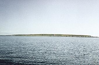
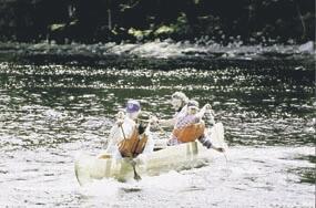
Bald Island one of the many Islands in the Tusket Islands Chain."When are you planning on going?" I asked. "Tomorrow morning, 6 am at Pinkney Point Warf. Sound OK?" Not a hell of a lot of time to prepare but I agreed. Now I get off work at 12:00 am, takes half an hour to get home. Another 45 minutes to get my gear collected, lunches made etc... Get to bed around 1:15 am - 1:30 am, didn't get to sleep I know till about 2:00 am I was so excited. I should let you know this far in that the Clare Canoe Club, which these fellows who asked me on this trip are members of, travel in a 24' Mi'kmaq' War Canoe. Another reason I was anxious to go. A little note to all you married folk out there. Best let your wife know where you're going, even if it is 5:00 am. Let me tell you she thought I was out of my mind but in true adventurous fashion I went anyway with about 3 1/2 hours sleep. I met with them at 5:30 am in Arcadia and got into their van and meet the fellows. Andre Belliveau whom I spoke with on the phone, ????? ?????? and Andre's brother Guy Belliveau. "Well I'll be damned." I said. I used to work with Guy years ago and hadn't seen him in about 6 or 7 years. He went off to become a fisheries officer and I hadn't seen him till that morning. We got to Pinkney Point Warf at 6:00 am. Fog as thick as Jackie Stewart's Scottish burr. Couldn't see 20 yards ahead of you, no lie! We unloaded the war canoe and slipped her into the water. I had noticed there was a huge inflated inner tube stuffed under the middle seat. Curiosity got the best of me and I had to ask "what the hell is that for?" "Oh that... that is for flipping the canoe back over in the event that we tip." After explaining the procedure of righting the canoe in case we take a spill the assured me that "that wasn't going to happen.. Right?" More instruction on how to change paddle sides followed. You have to see this canoe to appreciate its size.
 |
|
We all take position and we practice our routine for changing paddling sides. The canoe seats are so wide that you just don't change paddle from one hand to the other but you literally slide over to the other side of the canoe. Remember that it usually takes a crew of eight and we were only four so the seat is only half full. When a change of side is called, which anyone could call for a change of side, there is a count of four. ONE.. paddle comes out of the water and lays across the gunnels. TWO.. paddles come up and held straight up. THREE.. in unison, and this cannot be stressed to much because if it wasn't done in unison the boat would become unbalanced and the chances of tipping are greatly increased, we slide over to the opposite side of the canoe. FOUR.. paddles are in the water starting a new stroke. After a few changes we got really fancy and we added a banging on the gunnels on the one count and the four count just before we put the paddles in the water. We almost had the look of real Voyageurs if we had been in costume like they usually are when they go on war canoe rallies. Andre takes a heading with the compass and informs us that 15 minutes paddle away we should be within 100 yards of a dock on Big Cook Island. Off we go into the thick white fog. The sun just barely up and the cool damp mist made for an eerie ride. Twelve minutes into the trip a large black form loomed up in the water before us and just like Andre said. There was the island and we were less than 100 yards from the dock we had headed for. I was impressed with his navigational skill. Unlike traveling on lakes or rivers there are tidal currents to take into consideration when navigating on the ocean. Come to find out that these guys once traveled from Digby Nova Scotia to St John New Brunswick in this very canoe. They had one fellow that his only job was to keep watch on the compass. Guess that when they got to New Brunswick all the poor fellow could see when he got to bed was that damned compass. After a while, around 8:30 or so the fog began to lift and the sun peered through the thick blanket over head with a promise of a beautiful day ahead. From Big Cook Island we headed south to Murder Island Then to Candelbox Island, Then trough Schooner Passage to Owl's Head Island where there is an old building that is owned by an American but has never been kept up so it is falling into disrepair. Shame as it was a grand place in its day. Made of stone it looked more like a mansion (one storey) with a fine large veranda, large fireplace and a couple large bunk houses to the rear of the property. The floors have since deteriorated to the point that it is not safe to walk on and the roof is all but non existent. It had been used as a Boys Club or Scout camp in the 50's. Soon we came upon Pease Island. This island had been home to a lighthouse just a few short years ago and I now work with Albert Brambscombe the Light Keeper who shared this job with one other person. Albert and his wife and three children stayed on Pease Island for 3 years until the Coast Guard decommissioned the light there and on Green Island a few miles to the East.
 Pease Island |
 Abandoned boat ramp on Pease Island |
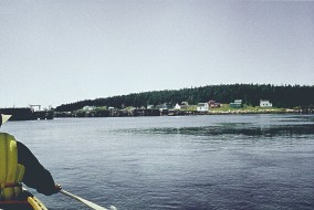
We stopped on Pease Island for a snack and it still has sheep wandering around. Local sheep farmers bring the sheep to the islands to graze as their fore fathers before them had done. Usually there are no predators on the island but recently the eastern coyote has made a resurgence in South Western Nova Scotia and have found their way onto the islands, this makes for an easy kill as the islands are small and the sheep have nowhere to hide when wylie coyote comes a callin'. Heading back we went to the eastern shore of Tusket Island and circled around to come up on Harris Island.
|
Harris
Island as well as Allen Island are the two main islands used in the
lobster fishing season as a base camp for the lobster fishermen from
Wedgeport. Lined with well maintained docks and shantys it is picture
postcard scenery. Harris Island is on our right here in this picture.
|
 |
 |
We had lunch on one of the docks on Harris Island and took in the warm early summer sun. |
We went around to the east of Tusket Island again so that we could get to "Hells Gate" or "The Sluice" apparently The Sluice was dredged up and cleared by the local fishermen so that the lobster boats would have a shorter distance to travel in stead of going all around the islands to get to their fishing grounds. As we headed up to The Sluice we had to wait just south of three islands, called "The Three Sheep". The tide was so low that there was nothing but sand between the three islands. You could have got out and walked to each island. Well ran to each one because the tide was coming in quite fast and after about 20 or 25 minutes we had enough (just enough though) water to float through to Hells Gate. Once at Hells Gate we had to wait a while for the tide to come in because the water was to low to play in. That's right... To play in! These guys wanted a little white water time in Hells Gate. Now picture this. Lots and lots of rocks, about 1/2 mile wide area, tide just barreling in through this sluice and a very cold tide it was. Needless to say I was a little more than a bit anxious about this but the guys seemed quite eager to go for it and I figure "Hey they are the experts here. I'm sure they know what they're doing." Tide comes in and water rises very quickly and there is the widest piece of white water I have ever seen outside of the Lachine Rapids on the south shore of the St Lawrence in Montreal. Popping in and out of eddies and ferrying across wide fast flowing currents we played there for almost an hour before the tide was high enough to wash out the rocks. No getting out to have a pee either! Talk about scaring the piss out of ya!
 |
Hells
Gate or "The Sluice". |
After that bit of excitement we wandered back around the islands and it was interesting to see signs on the shores warning fishermen not to drop anchor in the channels between some of the islands because there were power lines running under water to Harris Island and a few of the others. Soon it was time to head back to Pinkney Point warf. We had to paddle across "Turpentine Channel" which wasn't so wide but as we approached it I noticed that the water seemed to flow higher in the channel. Like it was about three inches higher than the rest of the ocean. This was one mean rip tide to be sure. Guy Belliveau explained to me that we were going to ferry across and to just keep my paddle in the water and let the current do all the work, "just like in the river" he said. Yeah right but with four people in the boat as apposed to one or two, which was what I am used to. We had to be very careful to attack the current at just the right angle because if we took it at to steep an angle the chances of being swept broadside and flipping over were pretty darned good otherwise. Now here is where I became the most concerned. Being swept over and carried out to sea this late in the day is not my idea of fun. Scared as I was we ferried over to the other side of the channel without even paddling forward once. We shot across there faster than we could have ever paddled that is for sure. Next we came to a narrow channel that we had to go up because it was getting late and the paddle around Tusket Island would take to long. The tide was against us as we paddled like mad men up this narrow passage. And I mean narrow, there was barely enough room for our paddles and we were digging bottom lots of the time, but we made it up through. Current was so fast that there was not time for a break. If you stop you were back to square one again. When we came up to the warf in Pinkney Point an old fellow asked where we had just come from. When Andre told him he seemed surprised. "You mean you paddled up through that small channel?" he asked. "Yeah sure, why?" Seems that the current there when the tide is rolling by is about 7 to 10 knots. Now that was a workout. Let me tell you, all day from dusk till dawn paddling a big 24 foot Mi'kmaq war canoe on little less than 4 hours sleep and a few light lunches and some granola, I was one tired puppy when I got home. But I'd do it again in a heart beat.

| Page
design By 2000 |
© |
|
| Sign
Guestbook View Guestbook |