In Atlantis -- The Eighth Continent, Charles Berlitz writes, "Strangely accurate maps were circulating around Europe at the time of Columbus, showing continents and shorelines that would not be discovered in some cases for hundreds of years. These were the Portolano maps, probably rescued from the ancient libraries and used for centuries as navigational tools by sea captains in great secrecy in order to protect their trade routes. But only in the last decades have these maps been recognized for what they were.
"At the time of their last copying they demonstrated a knowledge
of the existence of, 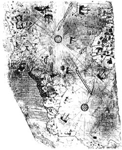 and
even the coastlines of, "undiscovered" continents; continents
that evidently were mapped by a past civilization but forgotten, except
on the recopied maps, after something happened that considerably altered
the face of the world. Investigations by Professor Charles Hapgood, of
the University of New Hampshire, of the Piri Re'is
map of the southern Atlantic and its shores (last copied in 1513)
established that spheroid trigonometry was used to establish correct longitudinal
coordinates, a process not rediscovered until the middle of the 18th century.
and
even the coastlines of, "undiscovered" continents; continents
that evidently were mapped by a past civilization but forgotten, except
on the recopied maps, after something happened that considerably altered
the face of the world. Investigations by Professor Charles Hapgood, of
the University of New Hampshire, of the Piri Re'is
map of the southern Atlantic and its shores (last copied in 1513)
established that spheroid trigonometry was used to establish correct longitudinal
coordinates, a process not rediscovered until the middle of the 18th century.
"The correct coastline of Antarctica was shown as it exists under the ice that now covers it. Another, the Oronteus Finaeus world map (1531), not only gives the most correct longitudinal coordinates but shows in the as yet undiscovered Antarctic continent rivers, valleys, and coastlines in their correct position under the glacial ice as well as the approximate location of the South Pole.
"Further research by Professor Hapgood, Maps
of the Ancient Sea Kings, revealed a treasury of ancient maps
in the Library of Congress, many of which show an amazing knowledge of
the Earth's true geography at a time when most people did not know that
the world was round and when cartographers were apt to fill in blank spaces
on maps with drawings of winged cherubs, monsters, or with the annotation
"here be Dragons." 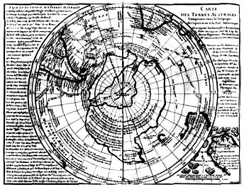 The
Bauche map (1754) shows the Antarctic continent without ice, divided
into two great islands, a fact not re-established until 1958.... The
King Jaime world map shows the Sahara, not as a desert, but as a
fertile land of rivers, woods, and lakes, which it once was -- before the
beginnings of chronicled history." -- Charles Berlitz (p 140f)
The
Bauche map (1754) shows the Antarctic continent without ice, divided
into two great islands, a fact not re-established until 1958.... The
King Jaime world map shows the Sahara, not as a desert, but as a
fertile land of rivers, woods, and lakes, which it once was -- before the
beginnings of chronicled history." -- Charles Berlitz (p 140f)
How is it that this knowledge was lost? Was it lost, or was it intentionally hid? You know -- limiting access to knowledge as was done in the "Dark Ages" when common folk were intentionally kept in the dark by people in the know who should have known better. I know these maps are not discussed in any text books at the public schools I've ever been around.
Hopefully, it's an oversight. Peddling those worn-out "flat Earth society" theories of the past isn't good research especially when we discover that not everybody was a member of that society though modern publishers still like to give us that impression.
I wonder who knew this remarkable information and recorded it hundreds and possibly thousands of years ago. I wonder who authored the Piri Re'is and other ancient maps. I also wonder what else is buried from both public view and knowledge by publishers who have gone soft on research. And by the way, where's the "media" in all this? You'd think with all the bad news they tell us everyday, they might be able to come up with an occasional interesting story like this, right? Why weren't we ever told me about these maps? Obviously, somebody has always known the world was round.
Check out The Los Angeles Central Library
Or, better yet! In this case, CHECK OUT
And Related Links:
The Smithsonian Institution Home Page
And NOW for a commercial break --
 Give the Gift of Language! If you'd like to learn more about "Teaching the WORLD... English", please check out: