(Published in the Philippine Daily Inquirer, February 21, 2004.)
ONE of my passions is trying to establish the historical basis of local myths, legends and folklore of the Leyte-Samar region. I have succeeded in unmasking the historical facts behind a few of them, but many others still need to be decoded one at a time.
Folklore of northeastern Biliran mentioned a "Punta de Bulalacao, Isla de Panamao" (Bulalacao Point, Panamao Island). This place is a component of an entire legend-complex that includes a fairy named Maria Benita, Spanish galleons, cargoes of cacao, and even a fabled "city" on top of Mt. Panamao.
Most of the components are strangely Spanish in label and identification, suggesting that the entire legend evolved during the Spanish era.
Of course, Isla de Panamao is the ancient name of Biliran Island, which was the site of the first large-scale Spanish shipyard in the Philippines at around 1600. And cacao in this colony was first planted by the Jesuits in Carigara, Leyte, according to the 19th-century French author J. Mallat. The Carigara parish originally included Isla de Panamao.
The "city" on the mountaintop probably evolved in the folk mind from the volcanic activity of the eruptive Mt. Panamao, whose peak glowed during dark nights, as described by Jesuit Fr. Francisco Alcina in 1668. The volcano presumably erupted a year later.
Maria Benita (Benighted Maria), the fairy, is associated with the religious controversy involving the towns of Almeria and Kawayan during the early American period at the turn of the 20th century, which saw the diminution of the belligerent town of Almeria into a barrio of Kawayan, a former barrio that was elevated into a town by American officials.
Confused cartographer
The search then left me with finding the location of Punta de Bulalacao (Bulalacao Point).
Natives of Kawayan claim that this geographical point is probably in the vicinity of Barangay Bulalacao, a few kilometers east of the town proper. The place was named after a bird called "bulalacao" in Waray-waray and "buwakaw" in Cebuano, which allegedly glows or sparkles at night.
I do not know the bird's English name, and I have not yet seen one. But it might have also given rise to the "St. Elmo's Fire" (santelmo) phenomenon in the folk mind.
Anyway, Barangay Bulalacao does not have a prominent headland that merits to be called a point. Thus, Punta de Bulalacao must be somewhere else.
The answer dawned on me a few weeks ago, while I was scanning the Leyte-Samar sections of Spanish-era Philippine maps and trying to firm up additional proofs for my theory on the name of Leyte in an earlier column on the narrow channel under Biliran Bridge.
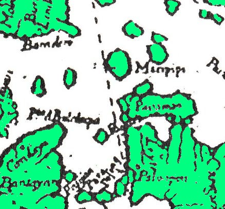
The first detailed map of the Philippines was drawn up by Jesuit Fr. Pedro Murillo Velarde in 1744. It was published in Manila in 1749 as part of his "Historia de la Provincia de Filipinas de la Compania de Jesus."
The cartographer was apparently confused about where Panamao Island was closest to Leyte. He bent the island and made it appear almost connected to the mainland in two areas - at the center and west of northern Leyte, respectively. He was wrong.
Earlier, in 1668, Father Alcina, who probably had not traveled through the Biliran Strait on his way to Samar where he served many years as a missionary, was himself confused about the location of Pogot Point (Beheading Point). His narrative placed this on the northwestern point of Leyte, along the western seaboard of the island opposite Cebu.
In Alcina's time, the easternmost part of Cebu across northern Leyte was known to the Spaniards as "Bululaqui." But the priest, who understood the local language, knew better. He said the word was a corruption of the native phase "buli-lacu" (i.e., buli daku), which is obscene in the Bisayan language. In English, it is "penis [is] big."
In the 1744 map, the northernmost point of Cebu, placed on almost the same latitude directly west of Panamao, was labeled Punta de Bululaqui. Its nearest village, on the vicinity of the present Daanbantayan, was known as Candaya. This village was probably the Cebu extension of the Kan-Daya (of the Big Boat) kingdom in Samar.
A joke?
There might have been an intended joke that escaped the Spaniards. The man who was famous for his big boats was also famous for a huge physical endowment.
After 1749, Spanish traders who traveled on their cargo boats probably brought along with them a copy of Fr. Murillo Velarde's map. While in Isla de Panamao to take in cargoes of cacao, they would presumably ask from the locals about Punta de Bululaqui, which was expected to be visible west of the island.
Unfortunately, then and now, the northern part of Cebu could not be seen from Biliran Island at sea level. And the natives, in trying to figure out the strange word, might have heard "bulalacao" and pointed to the habitat of the "sparkler" birds north - not west - of the island.
And there started a legend. In due time, the language confusion created in the folk mind a mirage known as Punta de Bulalacao, which may not be found in Isla de Panamao.