|
The Assembly of Indirect Evidence for RUAIRIDH BREAC MACNEIL — "THERE WAS A SOLDIER . . . ."
His MIGRATION to CAPE BRETON
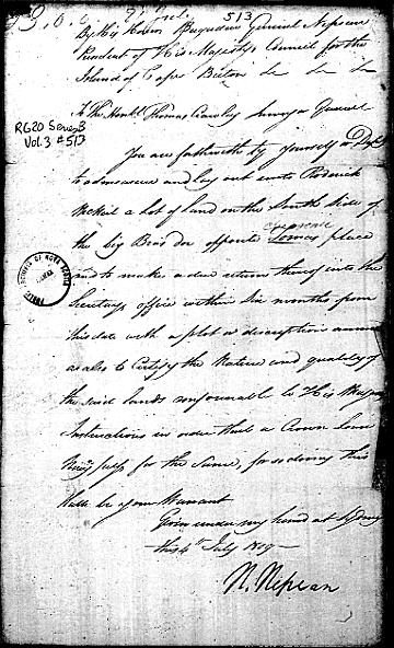
The land to which Governor Nepean refers in 1809 is Big Pond, Cape Breton, located at 45° 54' North, 60° 32' West on the eastern shore of Bras d'Or Lake. In these geographic terms, it is a settlement at a small cove along St. Andrew's Channel where the brook, known yet today as 'Breac Brook', spills into the lake.
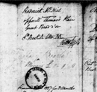
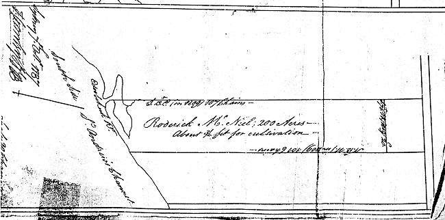
The Kincaid thesis (1964) notes the distinction between 'license' and 'permission' in Cape Breton land grants as merely "whimsical".38 In her compilation of old land records, Governor's papers and Minutes of Council, Kincaid attempted to annotate each name to indicate not only the places of origin and settlement, but also the date of arrival and number in the family. She finds "Rod'k McNeil" as one among sixteen Rod'k McNeils and Rod'k McNiels entered in the Cape Breton land papers in the first two decades of the 1800s. The 1809 warrant for Rod'k McNeil is included, indicating his place of settlement "Big Bras d'Or Lake", but no mention of dependent children.39 To request crown land, normal procedure in the early 1800s was for an applicant to submit a petition to the Governor requesting a specific parcel or plot. Next, assuming the petition was approved by the Council, (or that there was a Council) the Governor would issue a warrant, as Governor Nepean has done in Roderick McNeil's case. Once the lot was surveyed and recorded, a copy of the grant would be issued to the petitioner as proof of ownership. But because of the prohibition by the British government, until 1817 only leases and licenses were available.42 Often, years, decades, would pass before the actual paper work would be struck and mailed to the owner. The Crown Grant that finally was issued to Ruairidh Breac appears drawn but not recorded until 1838! It was attached to another batch of grants for petitioners at Irish Cove, about twenty miles west of Big Pond. On the 6th day of December 1838, Rupert D. George, the secretary of the Legislative Council governing the colony of Nova Scotia, signed a deed in Book U, page 14 granting this series of lots in Cape Breton that had been surveyed years earlier. The description of the piece allotted to Roderick McNeil is included: To the said Roderick McNeil a lot of land at Edoobukuk 43 on the south side of St. Andrews Channel bounded by a line beginning at a Stake at the point of Sandy Beach on the west side of the Entrance to open or Inlet thence running by the Magnet in the Year of our Lord 1809 South thirteen degrees East one hundred and seven chains thence south seventy five degrees, West in the Year last aforesaid twenty chains thence North thirteen degrees West in the year last aforesaid one hundred and one chains more or less to the shore thence along the shore Easterly to the place of commencement containing two hundred acres more or less agreeably to the annexed plan.44
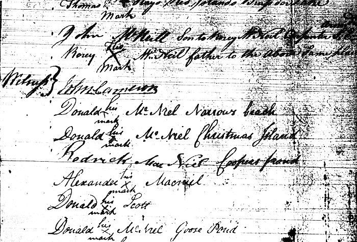
Finally there is a record in Cape Breton land documents that serves to identify Ruairidh Breac McNeil in a petition in 1812, again to Governor Nepean, for a grant to Charles McNab of 1,000 acres in "certain defined lots" for a mill site.45 The list of names attached to the petition, and the wording, are revealing. A summary is included in the Calendar of Cape Breton Land Papers: Petitioner, together with the whole body of Scotch settlers on the Bras d'or Lake ask that land reserved for the Tomwa Indians on the Tomwa Indian River be granted to McNab as a mill site, and that the Indians be induced to settle elsewhere. This calls, too, for a general survey of the district as the Indians have been giving trouble to new settlers twelve miles distant.
There are 62 signatories to the 1812 petition of "Scotch settlers": 29 of them are 'McNeil'. Seven are 'John McNeil' and four are 'Roderick' or 'Rory'. Beside almost every name, there is an identifier of some sort.
Without doubt, this McNab Petition is a definite stroke that establishes Ruairidh Breac and his son, John, on the land they had requested and they ultimately receive at Big Pond, Cape Breton. Ruairidh's lot was surveyed in 1809 and John's, not until 1817. |