|
Back to previous page
The Assembly of Indirect Evidence for RUAIRIDH BREAC MACNEIL — "THERE WAS A SOLDIER . . . ."
His PIONEER STATUS—
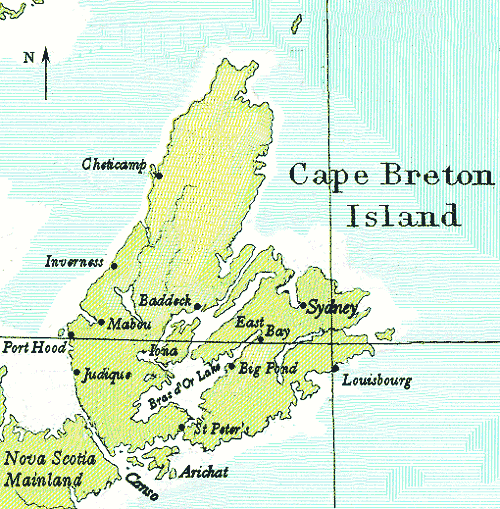
Was Ruairidh Breac the first settler, the pioneer, in Big Pond?
The key testimony in the identity search for Ruairidh Breac McNeil and the claims that he became the first settler in the district, appears in the handful of administrative documents of Cape Breton that survive: a case in point, the colonial census of 1811 and 1817/18. [The 1818 census was actually taken in 1817.]
From old church records in Cape Breton, it is possible to estimate the number of Scottish families at only around 300 by 1802.47 In August of that year a group of 340 emigrants from the Western Isles and Inverness sailed into Sydney Harbour and pleaded for land, provisions and subsistence allowances. Cape Breton's Governor Despard, generously accommodated them all with 'loans' of money, and permission to get on unclaimed land in order to prepare for the winter, but that boatload of Scots was the only formal immigration to Cape Breton for the next fifteen years.48 Yet, informally, the Highlanders continued to come across the Canso Strait from the Nova Scotia mainland: from Pictou,49 from Antigonish, Cape George, and across the Northumberland Strait, from Lord Selkirk's settlements in Prince Edward Island. They wanted land.
From 1789 until 1817 a proscription was in place barring the grant of any land in Cape Breton, although by the most rudimentary methods, by mounds of anecdotal evidence, by 1811 it was clear to everyone that the number of settlers on the island was expanding by the hundreds in almost every year. Hornsby, in his analysis of a wide variety of data, estimates that many hundreds if not thousands of Scottish settlers came in and took up land without any sort of official recognition during those years the proscription was in effect—until 1817.50
There was a head count taken in Cape Breton in 1811 (as it was in Nova Scotia), but those returns are incomplete and the few pages of entries that do survive are for the districts along the southwest of the island and around the southern heel.
The 1818 census,51 however, makes it possible to walk almost door-to-door with the enumerator, and because of its alignment with petitions, warrants and leases, it is feasible to know who exactly is on what land.52 There is a pronounced parallel between the designated owners of each land tract and the names counted in the census return. There are also other notable questions tabulated in this official count: how long has each adult been on the island, where had the head-of-family been born, and how many children were in the household.
At Big Pond, precisely on the land earmarked for Ruairidh Breac in his 1809 Warrant from Governor Nepean, as well as on the adjacent lots to the immediate left and right, there are four McNeils. The block of land comprises almost 800 acres at Breac's Brook (Big Pond) and those named on the census at this location are four young men: Donald, Rory, Alexander, and John McNiel. These four McNeil men are in all probability Ruairidh Breac's sons. The traditional stories declare that he also had daughters, and it is natural to assume he did, but this census named only heads-of-families, and all along St. Andrew's Channel, including the area of Big Pond, there were no women named as 'heads' in 1818—or named at all.
 Extract from Appendix B, Public Archives of Nova Scotia (PANS) Publication No. 2, "Holland's Description of Cape Breton Island and Other Documents," compiled and printed ("In order to save them while there is yet time") by D. C. Harvey, Archivist, in 1935; this index (handwritten) is also available at the Library and Archives, Canada (LAC), microfilm M-5219*. Online, the Index is at Cape Breton Counties Genweb: http://www.rootsweb.com/~nscpbret/cbgenwb.html.
*The handwritten count available at the National Archives includes the column in which the enumerator asked whether the person named had taken the Oath of Allegiance to the Crown.
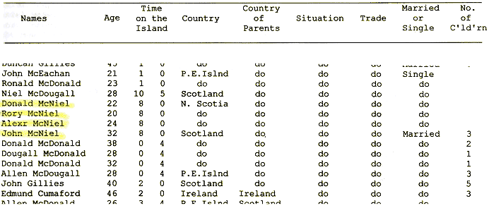
The columns represented on the Table (above) indicate the 'Time on the Island' in years and months [8 years, 0 months]. The origin or 'Country of Parents' [Scotland]; the 'Situation' refers to the location [St. Andrew's Channel]; and 'Trade' [farmer]. |
The four McNeil men at Big Pond all declare they have been on their land for eight years. This figure obviously arises from when the lots were formally claimed, as John had stated in his sworn petition to the governor in 1809 that he had been on the island four years since arriving with his father.
Age is also worth note in this analysis: On this census, through the entire District of St. Andrew's there is only one man in his late fifties, a John B. McNeil who arrived in a group from Barra and settled at Scots Point. His late fifties is the youngest possible age that Ruairidh Breac might have been in 1818. There is no candidate on the list that might be Ruairidh Breac. There is no one older than 67 (that is, John McMullen at Red Islands). A Roderick McNeil is there, having been on the island nine years, but he is only 17 and living near his father and two brothers. Hector McNeil, who has been on Cape Breton for 16 years, is age 48 and is located with his family of nine children on his land at Red Islands.
Only 84 names are listed along the 36 mile stretch of St. Andrew's from the entrance to the lake at St. Peter's and the sand bar at East Bay corresponding to the lots of land on the Crown Grants Index map No. 124.53 Of the 84, just 44 are married. Three of the McNeils at Big Pond are single, and John, age 32, is married and with three children in the household. The microform copy (National Archives M5219) of this early census included, also, a column recording the height of each man: Donald, 5'5"; Rory, 5'8"; Alexander, 5'6"; and John, 5'8½".
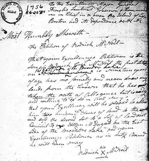
On the 3rd of March in 1817 (the year the proscription against granting land was lifted) Roderick McNeil, 19 years of age, filed his land claim. He declared that he is "the Son of Roderick Breac McNeil the first settler on the East side of the Bras d'Or Lake" [emphasis mine], and he requested 200 acres of land beside and along the same strip of lakeshore as John, Alexander and Donald.54
The land was granted with the proviso that it would not be official until young Roderick had reached the age of 21.
This combination of land records and census returns does make it clear: Ruairidh Breac was indeed the first settler, the pioneer, of Big Pond, or, as they called it then—Loch Mohr.
Twenty years later, instructions to the enumerators 55 for the 1838 census are that the count would begin from the District Line at Lot No. 1 (three lots east of the Hay's) and from thence, all along the shore of the lake "to Rory Bracks". The next enumerator was to walk "from Rory Bracks to Camerons". And—even today—to follow this path through the land petitions, leases, memorials and warrants—will take one directly to the land for which Ruairidh Breac received the warrant from Nepean in 1809. He is thus conspicuous by his absence in 1838, as he had been in 1818. Along that patch of coastline at his claim on Big Pond, there are two Rory McNeils in 1838, young men with young families, his namesakes.
Continue . . .
|