
ST Hills Home

Coyote Alamitos Canal
Santa
Teresa
Park
Open
Space
Bay Area Back Pages
Bay Area Biking
Bay Area Hiking
Future
Hopes
Feedback
|
NOTE: These pages are under
continual
construction, so check back frequently for updates.
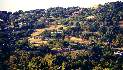
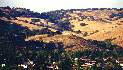
Despite their simple appearance, the Santa Teresa Hills are
remarkably
complex. This page attempts to show the beauty and variety of the hills
and why they are a precious resource worth preserving. Below are
pictures
of the Santa Teresa Hills, with a few of Santa Teresa County Park,
which
is covered in more detail in other pages (see the link to the left).
Click
on the thumbnails below to see larger pictures:
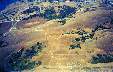
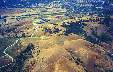
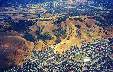
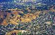
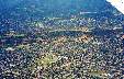
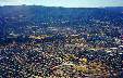
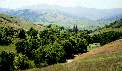
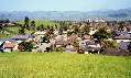
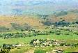
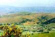
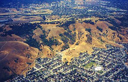
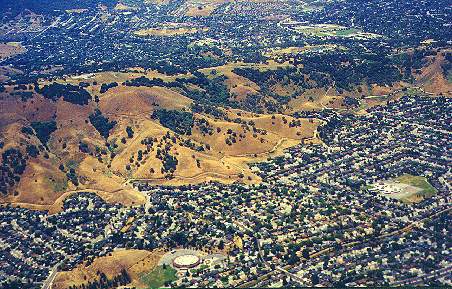
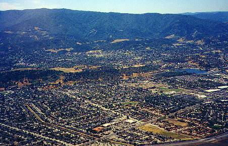
Aerial Pictures
These pictures were taken from a plane flight into San Jose Airport.
The
flight path for planes heading into San Jose runs up the Coyote Valley
and almost directly over antenna-topped Coyote Peak. As they head over
South San Jose, the north side of the Santa Teresa Hills can be seen.
The
Santa Teresa and Blossom Valley areas can be seen below the hills. The
Almaden Valley, the Los Capitancillos Ridge containing Almaden
Quicksilver
Park, and the high ridge of the Sierra Azuls can be seen beyond the
Santa
Teresa Hills. The mostly-undeveloped hills stand in stark contrast to
the
urban sprawl below them.
 |
 |
 |
 |
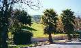
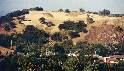
| Coyote Peak to Calero Reservoir |
Bernal Rd, Santa Teresa Park, IBM's Almaden Lab |
Joice Bernal Rancho to Cottle Road to Los Pinos Way |
La Colina Park to Snell Avenue |
 |
 |
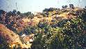
| Sakamoto School to Foothill Park |
Foothill Park to Lake Almaden |
 |
 |
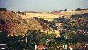
| Zoom in on hills |
Zoom in on hills |
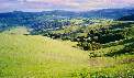
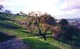
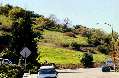
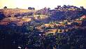
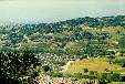
View of the Santa Teresa Hills From the Coyote Valley
The southeast end of the Santa Teresa Hills lies just above Bailey
Avenue
in the Coyote Valley. It is across Santa Teresa Blvd. from Tulare Hill
and the Coyote Valley Research Park. Most of the land in this section
is
undeveloped, so far, except for IBM's Santa Teresa Lab on Bailey
Avenue.
The lab takes up a very small portion of the land, which is mostly
owned
by IBM. The land in the hills behind IBM is leased by IBM to ranchers
for
cattle grazing and is off-limits even to IBM employees.
 |
 |
| View of the southeast end of the Santa Teresa Hills
from the Coyote
Valley by Santa Teresa Blvd. |
IBM's Santa Teresa Laboratory, looking east from Bailey
Avenue |
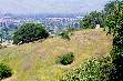
Views From Coyote Peak in Santa Teresa Park
The southeast end of the Santa Teresa Hills can be easily seen from
Santa
Teresa Park, particularly from Coyote Peak, the park's highest point,
and
from along the Boundary Line Trail, which runs along the park's
southern
border. Coyote Peak is one of the best viewpoints in the Bay Area. On
clear
days, Oakland, San Francisco, and even Mt. Tamalpais can be seen to the
north. Views to the south include the Coyote Valley and Morgan Hill.
The
view of the Santa Teresa Hills to the northwest is blocked by Bernal
Hill,
but the views to the south are unobstructed. The Santa Teresa Hills can
bee seen running southwest to the north and east shores of Calero
Reservoir. The hills in this area, which is unincorporated county land,
includes private ranchland and a luxury housing development along
Country
View Drive. East of the Santa Teresa Hills and Santa Teresa Blvd. is
Tulare
Hill, which marks the northern end of the Coyote Valley. Two
controversial
developments are being proposed next to Tulare Hill: the Metcalf Energy
Center and the Cisco Systems industial campus. The seasonal lake that
appears
south of Santa Teresa Blvd. is part of the land for the proposed Cisco
development, though the Cisco buildings themselves will be built east
of
Santa Teresa Blvd.
 |
 |
 |
 |
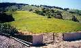
| Tulare Hill, Santa Teresa Blvd., seasonal lake, Coyote
Valley Research
Park, east edge of IBM property |
IBM Santa Teresa Lab property, Coyote Valley, Morgan
Hill |
West edge of IBM property, hills east of Calero
Reservoir |
Looking along the park boundary line southwest towards
the Almaden
Valley |
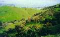
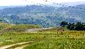
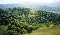
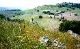
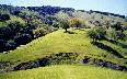
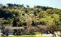
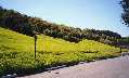
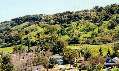
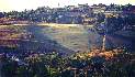
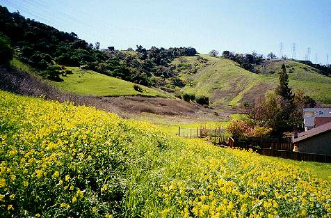
Tulare Hill to Santa Teresa Park
1688-acre Santa Teresa Park straddles the widest part of the Santa
Teresa
Hills from the Santa Teresa area to the Almaden Valley. It includes
some
of the highest and most diverse lands in the hills. While the Pueblo
Day
Use Area has parking lots and picnicking facilities, most of the park
is
undeveloped wildlands. Trails run over sunny rocky slopes and through
lush,
shady canyons. The outer trails provide spectacular views of the
surrounding
urban areas, while the inner trails provide views of the wild hills,
little
changed from the 19th century. Winter rains turn the grass-covered
slopes
a luxuriant green. Creeks, ponds, and waterfalls appear. Spring brings
out brilliant blooms of wildflowers. The park abounds in wildlife, with
deer, wild turkeys, hawks, and brush rabbits seen frequently.
Occasionally,
coyotes, bobcats, and mountain lions are seen. The park gives a sample
of what the rest of the hills are like.
 |
 |
 |
 |
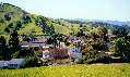
| Laguna Seca Community Garden on Manresa Court |
Field archery center at east boundary of Santa Teresa
Park |
Looking towards IBM from the Hidden Springs Trail in
Santa Teresa County
Park |
The Hidden Springs Trail below the Muriel Wright
Center, Santa Teresa
County Park |
 |
 |
 |
 |
| Walkers below Coyote Peak, Santa Teresa area in the
background |
On the Coyote Peak Trail, near Country View Drive |
Private hills southwest of Santa Teresa Park near
Schillingsburg Avenue |
Looking down the Fortini Trail in Santa Teresa Park
towards the Almaden
Valley |
 |
 |
 |
 |
| View of the IBM Almaden Research Center and Bernal Hill
from the Rocky
Ridge Trail |
Rocks on the Stile Ranch Trail, looking towards the
Mount Hamilton
Range |
Looking down towards the Joice-Bernal Ranch from the
Joice Trail |
Looking west down the Santa Teresa Hills from the Joice
Trail, horse
ranches down by Cottle |
San Ignacio Avenue to Cottle Road
Santa Teresa Park runs in the hills all the way to just above Cottle
Road.
Parts of the land below the hills belong to the park. Other portions
are
private or water district land. The Joice Trail and Vista Loop Trail,
which
are old ranch roads, run near the west edge of the park, providing good
views of the hills to the west. PG&E power line service roads run
right
to park boundary, which is marked by a fence running through a wooded
ravine.
Service roads and private ranch roads can be seen running through the
hills
to the west.
 |
 |
 |
| County Park property at the corner of Curie Dr. and San
Ignacio Ave. |
Water district property at the west end of Manila Drive |
West boundary of Santa Teresa Park behind St. Julie's
Church at Cottle
Rd. and Curie Dr. |
Cottle Road to Malory Drive
Near the end of Cottle Road is San Jose's Century Oaks Park. A wooden
fence
and sign listing park rules indicate that this is parkland, but it is
undeveloped,
with no established trails or facilities. However, informal trails lead
up to a small hill, which provides fine views of the hills and Valley.
More views from this hill can be seen in the Coyote-Alamitos Canal
page.
Century Oaks Park runs in a narrow strip below the Coyote-Alamitos
Canal
and above Curie Drive. Informal trails lead into the park. The 18
acreas
of parklands extend all the way to Galen Drive near Mindy Way. The
Santa
Teresa Hills south of Cottle Road rise to over 1000 feet. At the end of
Cottle Road is a private horse ranch. The hills from here on are
private
property. They are mostly undeveloped ranchland. Cattle can be seen
grazing
on the slopes.
 |
 |
 |
 |
| End of Cottle Road, Century Oaks Park |
View south from hill at Century Oaks Park by Cottle Rd. |
Century Oaks Park entrance on Curie Dr. east of Woosley
Dr. |
Century Oaks Park entrance on Curie Dr. east of Malory
Dr. |
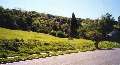
Views From the La Colina Park Hilltop
San Jose's developed La Colina Park, a popular place for youth sports,
has a small hill that is an offshoot of the Santa Teresa hills. The
bare
243' high hilltop provides 360-degree views of the area. Next to it is
a higher hill bisected by Valroy Dr. This hill is completely paved over
and developed, providing nice views for the people who live there, but
the houses block the views from the street.
 |
 |
 |
 |
| Looking towards the end of Santa Teresa Park (along the
treeline) above
Cottle Road |
View looking south down Pearlroth Drive |
View over the intersection of Los Pinos Way and Valroy
Dr. The hills
are over 900' high. |
View southwest over Valroy Ct. The hills dip down
to around 550'
here. |
Curie Drive and Didion Way
At Curie Drive and Didion Way is an easily-climbed hill in Century Oaks
Park, just below the fenced-off Coyote-Alamitos Canal.
 |
 |
 |
| Century Oaks Park at Curie Drive and Didion Way |
Looking from the hill at Curie and Didion towards La
Colina Park and
Santa Teresa Hospital |
Looking southeast along the hills down Curie |
Snell Avenue, Colleen Drive, Shadelands Drive, to Blossom
Avenue
In the hillside land below the Coyote-Alamitos Canal west of Snell is
San
Jose's undeveloped Coyote-Alamitos Canal Park, which runs to abround
Tillamook
Drive. Snell Avenue ends at the entrance to a private ranch road. The
grass-covered
slopes of the hills here are used for cattle grazing. Colleen Drive
runs
along the base of the hills. There are houses along Colleen, but
there are several open stretches between the houses. They are not
fenced
off. A large stretch of open field is near the end of Blossom Avenue.
Informal
paths lead up to the Coyote-Alamitos Canal.
 |
 |
 |
 |
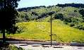
| View along hills west of Snell |
View along Colleen east of Gunter Way |
View from Sakamoto School of hills above Colleen and
Shadelands Dr. |
Hills along Colleen west of Blossom Avenue |
Glendora Court
Around Glendora Court are open fields along the hills. Even though they
are not fenced off, they are posted.
 |
 |
 |
| Hills above Colleen east of Glendora Court |
Hills above Glendora Court, looking southeast |
Hills above culdesac in Colleen Drive west of Glendora
Court |
Views From Foothill Park
San Jose's Foothill Park encompasses a small 240-foot high hilltop at
Cahalan
Avenue and Foothill Drive. The partially-developed park's main
attraction
is its marvelous views of the Santa Teresa Hills and the South San Jose
area. More views from the park can be seen in the Coyote-Alamitos Canal
page. The hills from this point on begin to be more heavily forested.
 |
 |
 |
| View southeast. Buildings can be seen on the ridgeline.
The hill in
the distance is over 900' high. |
View looking over Rocky Glen Court. A water tank at
400' can be seen. |
View south. The Coyote-Alamitos Canal can be seen at
the base of the
hills, which areabout 570' high here. |
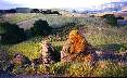
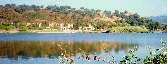
Miracle Mountain Drive to Lake Almaden
Near the end of the Santa Teresa Hills above Miracle Mountain Drive is
a hillside clearing with a stone monument on it. Steep informal paths
lead
up to the monument, whose purpose has been obscured by vandalism. The
Santa
Teresa Hills end at Lake Almaden by Winfield Blvd. An overgrown road
leads
up the hill from Winfield Blvd. to a transmitter station near the top
of
the hills. Alamitos Creek and the Alamitos Creek Trail run along the
base
of the west end of the hills. Lake Almaden was once a rock quarry pit.
It is now the focus of a popular city park. Alamitos Creek drains out
of
Lake Almaden, joins Guadalupe Creek, and becomes the Guadalupe
River.
 |
 |
 |
| Monument on hill above Miracle Mountain Drive |
View across Lake Almaden at the western end of the
Santa Teresa Hills |
View of Lake Almaden from road to transmitter station
in hills |
Boulder Ridge Golf Course Construction, Almaden Valley
The controversial Boulder Ridge Golf Course is being built on the
southwest
end of the Santa Teresa Hills above the Almaden Valley, despite the
protests
of neighbors and archaeologists.
The golf course is anxiously
awaited by golfers, who complain about the low ratio of golf
courses
per capita. Unlike the public Santa Teresa Golf Club at the opposite
end
of the hills, the Boulder Ridge Golf Course will be semi-private, which
means the public can access it, but at a high price. Even though the
golf
course is technically open space, it is not a natural environment. The
irrigated, fertilized lawns will be green all year and may be nice to
look
at, but will alter the ecological balance in the hills, possibly
favoring
some non-native species at the expense of native species that are
adapted
to the dry hillside environment. It is not clear whether homes will be
allowed to be built around the golf course. The golf course property
includes
boulders and caves that were once used by the Ohlone Indians.
Archaeologists
are afraid that Indian sites will be disturbed by the golf course
construction.
(See here for more
information
on the golf course.) To be fair, the golf course may prevent another
threat
to these sites: vandalism by trespassers.
 |
 |
 |
 |
| Construction at west end of hills above Alamitos Creek
Trail south
of Lake Almaden |
Construction in hills south of Mazzone Drive |
Construction in hills north of Mazzone Drive |
Looking at hills south of Crossview Circle |
Almaden Valley View from Guadalupe Oak Grove Park
Guadalupe Oak Grove Park includes an oak forest and a rocky undeveloped
hillside, a miniature version of the Santa Teresa Hills. The park's
hills
provide good views of the Almaden Valley and the Santa Teresa Hills.
 |
| Looking down the Alamden Valley along the Santa Teresa
Hills. Houses
in the hills can be seen. |
Rocks in the Hills Above the Almaden Valley
One feature that distinguishes the Almaden Valley side of the Santa
Teresa
Hills from the Santa Teresa side are the huge rock formations in the
hills
on the Almaden side. Rock quarries operated here many years ago.
Buildings
at Stanford University and downtown San Jose were built of stone
quarried
from these hills. These rock formations also include small caves and
huge
jumbles of boulders that would make a wondrous playground for rock
climbing
and exploring. They rival the rock formations at Castle Rock State
Park.
There is just one problem: they are all on private land. Huge luxury
homes
begin to occupy the hillsides and ridgetops east of Stonehill Drive.
They
are the other feature that distinguishes the Almaden Valley side of the
hills from the Santa Teresa side.
 |
 |
 |
| Sandstone formations in hills above homes |
Looking up Rocky Crest Drive at large rock formations
in hills |
Rocky hillside at Boulder Mountain Way and Rocky Crest
Drive |
 |
 |
| Rocks by Boulder Mountain Way |
Houses on ridge above Stonehill Ct. |
Almaden Valley Views from Woodview Place
Woodview Place is on a hill north of Almaden Expressway and west of
Alamitos
Creek. Views from here show the most heavily-developed portion of the
Santa
Teresa Hills. Luxury homes and ranches colonize the hills. These are
all
private lands. Trespassers are definitely not welcome. These homes
illustrate
that hillside development is possible in these hills. Fire is a
constant
danger here during the dry season. Ridgetop homes were threatened by
the
grass fire on the Santa Teresa side of the hills, seen on the home
page.
 |
 |
 |
 |
| The Santa Clara Valley Water District's Santa Teresa
Water Treatment
Facility can be seen on the right. |
There is a large open field here, with homes on the
ridgeline above
it. |
More homes can be seen here, some surrounded by large
open fields. |
Huge homes and ranches line the hills from top to
bottom in this area |
 |
 |
 |
| The homes in this area are especially large, surrounded
by non-natve
vegetation, such as palm trees and Italian cypresses. |
The hills above here are mostly undeveloped private
ranchland. |
View above Harry Road. IBM's Almaden Research Lab peeks
over the hills.
Most of the land south of this area belongs to IBM and is undeveloped. |
Santa Teresa Hills from Almaden Quicksilver County Park
Almaden Quicksilver County Park occupies most the Los Capitancillos
Ridge
on the west edge of the Almaden Valley. Views from the trails can be
spectacular.
The Hacienda Trail provides excellent views of the southern Santa
Teresa
Hills.
 |
 |
 |
 |
| Looking up Harry Road to developed section of the hills |
Fortini Road, Fortini Trail, Stile Ranch Trail, Santa
Teresa Park |
View of Coyote Peak, Santa Teresa Park, Schillingsburg
Avenue |
New and future housing development sites on Country
View Drive |

View of the developed section of the Santa Teresa Hills
from
Almaden Quicksilver County Park, Harry Road is in the center
Why Preserve the Santa Teresa Hills?
-
Aesthetically, the undeveloped hills contribute to the beauty of the
area.
They form a natural backdrop that provides visual relief from the urban
sprawl on the valley floor. The hills bloom with wildflowers and are
cloaked
in lush green grass in the spring, making them a beautiful sight. In
contrast,
houses in the hills increase the appearance and feeling of urban
overcrowding.
As an example, see the hills of Daly City.
-
The hills are a unique environment, one of the few hillside areas of
open
space in the Silicon Valley surrounded on both sides by dense urban
development.
The hills are an island refuge for wildlife.
Development can threaten this.
-
The hills have tremendous potential recreational value. Santa Teresa
Park
gives a sample of this. Its hilltops and hillside trails provide some
of
the best views in the Bay Area. The hills contain cool, shady forests
and
rugged rock formations that invite exploration. If the hills are
developed,
this can lock up those parts of the hills forever, preventing their
conversion
into parkland.
-
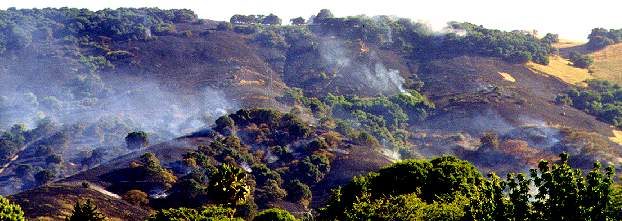
Building houses in the fire-prone hills is an invitation to disaster.
The
Oakland firestorm and similar fires all over Calfornia show the danger
and folly of hillside construction. The Santa Teresa Hills frequently
catch
on fire. The last fire threatened homes at the top of the hills.
Luckily
there were no homes on the hillsides or they might have been destroyed.
(See the picture on the home page.) If
homes
are built there, firefighters may be forced to take more urgent and
risky
measures to try to save them, possibly putting their own lives in
danger.
More resources would have to be dedicated to fighting the fires, making
them more expensive to fight. Concentrating on saving homes might give
second priority to undeveloped lands, resulting in the wider
destruction
of wildlife habitats or parklands.
-
Landslides are another potential danger, not only for houses in the
hills,
but for houses at the base of the hills. Construction up in the hills
can
increase the risk of landslides to homes below them, as has happened in
other parts of the state, such as Pacifica.
-
The destruction of multi-million dollar hillside homes in fires or
other
natural disasters is not just a problem for their rich owners. It can
raise
insurance rates for everyone.

Created 11/6/00 by Ronald
Horii
|


