“It’s now or never and no second chance" was how one journalist described the travels of English novelist John David Morley to Lamalera, a remote fishing village in Indonesia. Although John Morley had heart problem and was using a pig’s valve to replace one faulty valve in his heart, he was still game to risk his condition together with the attendant dangers associated with the remoteness and inaccessibility of the destination. And all for his heart’s, desire to observe the near extinct practice of hunting sperm whales as a subsistence living.
Our overland journey into Tibet was nowhere so dramatic but counting all the odds, it felt quite comparable! The overland journey would pose a challenge for anyone but more so for our group of ten elderly participants (the average age was 65 with the oldest members at 78 and 77)if we consider the long hours on the road, the high altitudes we had to reach, and the fear of being trapped for hours on the mountain passes.
With mountains rising up to 7000m and peaks topping 8000m above sea level Tibet, has achieved fame as the Roof of the World. It is indeed not a land for the faint hearted or the old. And if Tibet is the Roof of the World, then Qinghai, which is the remote and equally forbidding province sitting on top of Tibet must be its Rooftop! And we were to traverse across this bleak and treacherous region known as the Qinghai-Tibet Plateau into Lhasa. On the plus side, land travel into Tibet may be the best way to go, not only for the spectacular scenery en route but because it can help spread the altitude gain over a few days.
What then drove us to embark on such an “expedition"? It was not a rite of passage. We were not out to prove our strength in the face of halting youth nor were we marking our aging. Unlike Morley I did not have heart problems but suffered from aches and pain. However I had long been enamoured of the Qinghai/Tibet Highway lured as I am by the evocative place names of Kunlun, Tanggula, Re-Ye Shan, and Feng Huo Shan, and the giddy heights associated with these remote mountains.
The idea of retracing Princess Wenchen’s journey into Lhasa was another strong pull. Among other sweet dreams I had been nursing about Qinghai and Tibet was this strange one. I fancied myself as a pilgrim taking the arduous overland road and tolling my beads all the way into Lhasa. Never mind if I could not emulate pilgrims who prostrate and kneel, at least I would not be arriving on a jet plane. Was this the meaning of embracing hardship or what the Chinese call the spirit of “jian ku"?
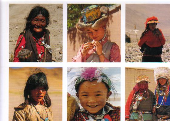
What the 78 and over 70’s in our group were seeking I do not know. Perhaps they did feel “time’s winged chariot" drawing near but from the positive energy they generated no one was having a death wish! They were a tough old bunch, these oldies. Not unlike the mountains we were to traverse.
Our adventure started in Xining, the capital of Qinghai, at the modest elevation of 2295m. The Qinghai-Tibet Highway which
leads into Lhasa is a paved road covering 1947km and is the highest highway in the world passing through mountain roads above 5000m with the highest pass at Tanggula at 5231m. A journey along this highway is truly one of those one in a life time trips.
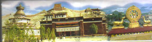
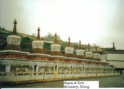
The Ta’er Monastery is arguably one of Xining’s most famous landmarks. It is one of the six biggest monasteries of the Yellow Hat Sect branch of Tibetan Buddhism and the birthplace of Tsong Khapa(1357-1419) the founder of the Sect. Apart from being a repository for Tibetan culture and heritage the monastery also displayed an unusual blend of Chinese and Tibetan architecture with Chinese upturned eaves sitting on Tibetan flat roofs. On our walk through the temple complex we saw stupas, eight in a row for luck, gigantic prayer bells, tapestries, flags and murals all reflecting bold Tibetan colours.
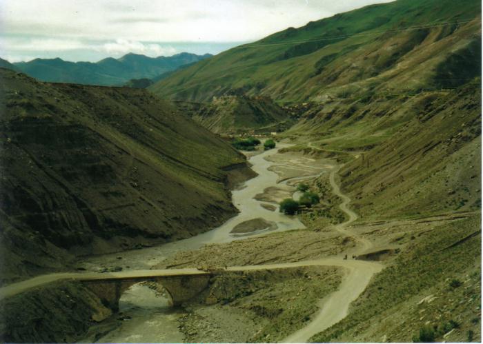
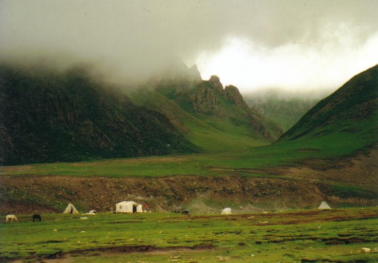
Moving southwest along the highway we continued to Qinghai Hu located 130km away. Onroute the sparsely populated Qinghai grasslands present a lovely folorness - goats, sheep,yak, donkeys,nomad's tents,herder's guts and camp fires appear as blobs on the vast plains.Tibetan prayer flags and cairns are also part of the lonely landscape.
The fabled Tangbo road, as it was known in past decades, now a paved highway is as redolent with history as with mountains. It has formed part of the Silk Road since the 3rd century BC., after the region came under Chinese control. Tragedy is also a common thread on this route if we recall how many travelers since time immemorial have perished during the hazardous journey. In recent times countless lives have been lost building this highway.
The most famous historical figure passing this way was Princess Wencheng of the Tang Dynasty. In the seventh century she was sent in a political marriage to King Songtsen Gampo of the Turbo Kingdom (Tibet). The marriage must have been a success as the Princess is much loved by both the Han Chinese as well as the Tibetans. Both groups have built shrines and memorials in her honour.
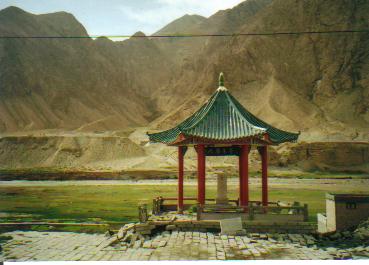
After driving about 2hrs we approached the Re-Yue Shan (Sun Moon Mountains). This is a very important pass and got its name when the grief stricken princess, discarded her Sun-Moon Mirror in a symbolic gesture indicating her severance with her homeland. A sympathetic river near by even changed its course to empathise with her plight, the Dao Xiang He (Back Flowing River) is said to be dedicated to her. A pavilion located on a hillock has been erected in her honour.
The overcast sky, craggy terrain, and bleak horizon conspired to recreate history for us. It is indeed an eerie, mournful place filled with the ghosts of yesteryear. Sharp winds whipped at feeble umbrellas and bitter rain hit us as we struggled gallantly up the hill to pay homage to the patriotic princess. The pass is at 3510m above sea level and this slight exertion had us catching our breadths.
Qinghai hu or Koko Nor Lake our overnight destination is at 3239m elevation. It is the largest salt water lake in China and famed for its scenic lake views but the drizzle made sightseeing unpalatable especially since a few of us were nursing headaches, nausea and palpitations, all symptoms of altitude sickness. And this was only the first day on the road.
Our hotel is a complex of single storey buildings set within a sprawling compound not unlike our holiday bungalows back home. Although the buildings look run-down the rooms were clean and furnished with quaint old furniture, rather a refreshing change from the modern hotels in big Chinese cities. The only complaint was the shower lacked a shower head and the chambermaid tartly advised me to exercise some creativity if I needed to wash! That night with 2 panadols and a sleeping pill it was sweet slumber on a pillow full of beans.
From Qinghai Hu we returned to Xining to catch the overnight train to Golmud. We traveled soft bed class, four to a cabin with no private facilities attached. The train journey took us over the salt marsh region of Qinghai. The Salt Lake and Salt Pond formed by the action of glaciers is the largest salt production site in China. Part of the rail track and Highway is built on a Salt Bridge. After an uneventful night, we arrived in Golmud at midday. Golmud is close to the borders of the Gobi desert and it is a dusty dreary place. Golmud at 2800m marked the start of the “Roof of the World" section of the Highway where we would encounter all the Big Passes. It was also our acclimatization day to prepare for the high altitude ahead.