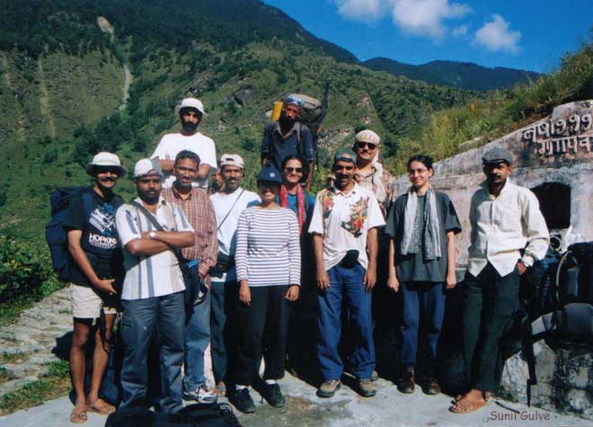
 The twelve of us left by the Golden Temple Mail (10:20 pm, Mumbai Central). A
group of climbers, attempting to scale the Kedar dome, were also on board. We
intersected till Haridwar, where they took the high road.
The twelve of us left by the Golden Temple Mail (10:20 pm, Mumbai Central). A
group of climbers, attempting to scale the Kedar dome, were also on board. We
intersected till Haridwar, where they took the high road.
The twelve of us left by the Golden Temple Mail (10:20 pm, Mumbai Central). A
group of climbers, attempting to scale the Kedar dome, were also on board. We
intersected till Haridwar, where they took the high road.
The train journey took us through surprisingly verdant Rajasthan. Past Mathura, was fortunate enough to spot a pair of Sarus cranes (no doubt playing hookey from Bharatpur), their maroon collars in sharp contrast to an otherwise grey plumage. The wire squatters – doves, rollers, drongos, etc. were visible throughout. As we neared Delhi, peacocks and hens could be easily sighted.
A tedious switch from New Delhi to Old, to catch the overnight Mussourie Express to Haridwar (the Rishikesh bogey is shunted at Haridwar, and stays put for three hours before being picked up).
A 2´2, 26-seater GMOU bus to Badrinath was leaving at 8 am, and we were conned by Gaylord Travels into paying Rs. 170 for a Rs. 135 seat to Nandaprayag. Beware the smooth talking Gaylord Travels proprietor, who makes a living ripping-off the devout .
Haridwar to Nandaprayag is a 7-hour journey along the Ganga and its grand tributary, the Alakananda. The road takes one by the four great sangams, Deoprayag, Rudraprayag, Karnaprayag, and Nandaprayag. (Of the four, only Nandaprayag is worthy of a second glance. The other three are typical, yatri-centric, Hindu hell-holes). The captivation begins with the air turning clean and crisp, the sky turning a striking electric blue, and the river humming an ancient hill hymn. As one gains height, the lazy majesty of the lower Himalayas slowly begins to hypnotize, and the first sight of a snow-capped peak far in the distance promises of days of enchantment.
 At Nandaprayag, we were booked at the GMVN guest house, but of course, they had
not received word from the Mumbai office (where we had booked three weeks ago).
Luckily the dorm rooms were empty, and Gyan (our guide) and his men provided us
with tea and Glucose biscuits.
At Nandaprayag, we were booked at the GMVN guest house, but of course, they had
not received word from the Mumbai office (where we had booked three weeks ago).
Luckily the dorm rooms were empty, and Gyan (our guide) and his men provided us
with tea and Glucose biscuits.
 We spent the evening at the Nandakini-Alakananda sangam. Alakananda meanders,
roars, and merges with the gently rippling Nandakini. Our trek will take us
east, upstream the Nandakini for a while, and then we shall head
north-northeast.
We spent the evening at the Nandakini-Alakananda sangam. Alakananda meanders,
roars, and merges with the gently rippling Nandakini. Our trek will take us
east, upstream the Nandakini for a while, and then we shall head
north-northeast.
The route is also called the Curzon trail, in honour of the brit viceroy Curzon, whose expedition ironically did not make it across the pass. An irate bunch of native bees foiled this relatively modest attempt at colonial domination.
I personally think that the height of a mountain is among the most asinine of statistics - numbers certainly have their place, but shouldn't they be limited to expressing the distance between railway stations (how else would one calculate the fare, aesthetically?), or one's dimensions while getting a pair of trousers tailored? However, for the linear minded, the heights of various points have been included.
Morning spent packing, checking provisions, etc. At 2 pm, we left Nandaprayag by jeep, for a 19-km ride along the Nandakini to Ghat. (Ten years ago, transport on this road was not easily available and more often than not the trek began at Nandaprayag.)
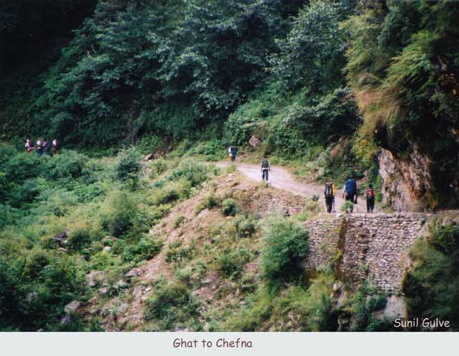 Ghat - Chefna:
a delightful 5-km level walk. The soothing roar of the Nandakini accompanied us
all the way to Chefna, where we camped for the night. We had one halt at a
Shiva temple by a bridge, and appropriately enough, Shiva's divine plant was
growing unhindered all along the way.
Ghat - Chefna:
a delightful 5-km level walk. The soothing roar of the Nandakini accompanied us
all the way to Chefna, where we camped for the night. We had one halt at a
Shiva temple by a bridge, and appropriately enough, Shiva's divine plant was
growing unhindered all along the way.
 Awoke at 6. A porridge breakfast. Began walking at 8. A long ascent to the
village of Ghuni, visible far in the distance. Nandakini leaves us, as we head
northwards (she originates at Homkund).
Awoke at 6. A porridge breakfast. Began walking at 8. A long ascent to the
village of Ghuni, visible far in the distance. Nandakini leaves us, as we head
northwards (she originates at Homkund).
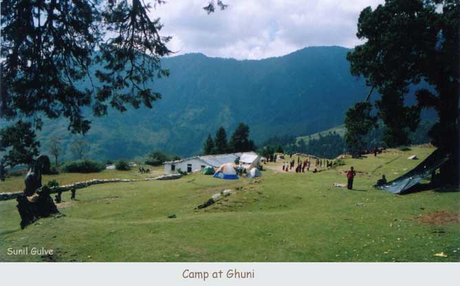
First halt at 9:20. First sighting of Nanda Ghunti (the Devi's veil) and other snow-capped peaks. Ascent continues through several villages to Ghuni. Reached at 11:45. Cold, even at noon (Ghuni is at 2500 m). Camped near the school, under a grove of conifers. Magnificent vistas all around. (Ramni, the neighbouring village, was the halting place for Madhu's trek ten years ago).
 On reaching village Ghuni, passed their paan-chakki (water-driven mill), which
is used to grind grain. A wonderful example of appropriate technology and
collective living. Was spectator to a stunning display of advanced aerodynamics
by shikras – their wings flap so rapidly that they freeze in mid-air, before
diving gracefully towards their prey.
On reaching village Ghuni, passed their paan-chakki (water-driven mill), which
is used to grind grain. A wonderful example of appropriate technology and
collective living. Was spectator to a stunning display of advanced aerodynamics
by shikras – their wings flap so rapidly that they freeze in mid-air, before
diving gracefully towards their prey.
Noon to 2 was lunchtime at the school, and the older kids played volleyball. The younger ones lazed in the sun, and found the antics of us aliens, like pitching tents and unpacking, most fascinating.
 Our ponies rested neath the pines. The evening was spent listening to the India
- SA semi-finals (ICC Champions Trophy in Sri Lanka). Walked to a nearby
vantage point to watch the sunset and the changing hues on Nanda Ghunti. The
route to Roopkund via Sutol was also visible.
Our ponies rested neath the pines. The evening was spent listening to the India
- SA semi-finals (ICC Champions Trophy in Sri Lanka). Walked to a nearby
vantage point to watch the sunset and the changing hues on Nanda Ghunti. The
route to Roopkund via Sutol was also visible.
Thirty-two 9th standard kids from Navjot Singh Sidhu's school in Mohali camped nearby. They left a trail of aluminium foil wrappers all the way to Kuari Pass (and all the way back to Mohali no doubt). Shetal and Madhu did their best to mitigate the effects of our nation's elite educational institutions, collecting what they could.
 Luckily the school was closed too (so we were spared the relentless curiosity
of the congregation). Watched the sunrise from the vantage point. Did some eye
exercises, while Uddhav and gang photographed to their hearts' content.
Luckily the school was closed too (so we were spared the relentless curiosity
of the congregation). Watched the sunrise from the vantage point. Did some eye
exercises, while Uddhav and gang photographed to their hearts' content.
First bath in an Himalayan stream – applied the Waghulde Theorem of Bathing by Parts . Wash the head, dry it. Then the torso, dry it. Then finally the limbs. Excellent method to avoid hypothermia. Make sure the sun is up, so that the body can warm up after the chilling, head-shrinking dip. Always one of the more enthralling moments on a Himalayan trek, when one immerses one's head into a sparkling, chilled Himalayan stream. No trek is complete without it.
Pre-lunch walk to Ramni via a horticulture centre. The village was deserted, as the entire population was working in the fields.
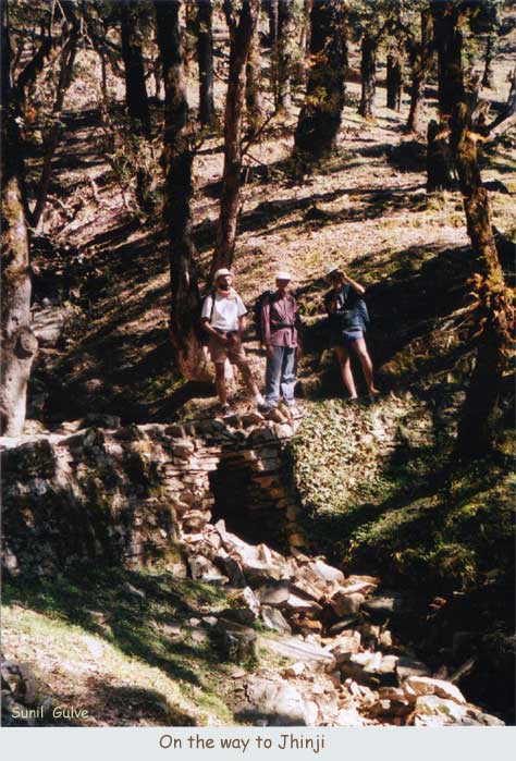 Started at 7:45 a.m. Two ascents from 2500 m to 3010 m (Chechni Vinayak is the
highest point, providing stunning views). Then a descent through a thick
forest, with streams abounding. Shikras and hawks hovered during the ascent.
Camped at Sem Kharak (a clearing above Jhinji) enveloped by trees, which we
reached at 1:15 p.m.
Started at 7:45 a.m. Two ascents from 2500 m to 3010 m (Chechni Vinayak is the
highest point, providing stunning views). Then a descent through a thick
forest, with streams abounding. Shikras and hawks hovered during the ascent.
Camped at Sem Kharak (a clearing above Jhinji) enveloped by trees, which we
reached at 1:15 p.m.
Spent the afternoon eating walnuts and listening to the Lanka - Aussie semis. A pack of langurs froliced nearby. The sun vanished behind the hills at 4:30 p.m. Clear, cold night.
One hour descent to Jhinjipani village. Walk past the school to a stream. A long pause as a river of sheep flows past. Mother sheep bleat frantically, running against the flow, sniffing all to identify their young ones. Bringing up the rear are the tiny tots, some barely able to walk, and some stuffed in saddle bags, with their tiny heads peering out in newborn bewilderment. It is the onset of winter and the shepherds are returning to their villages from the buggials (grazing grounds) higher up. Rugged men leading tough lives – six months of wandering in the mountains with their flock.
 Past the stream, we crossed the suspension bridge across the Birhai Ganga.
Madhu, the science teacher, measured the drop to the river to be 4-5 seconds.
That's around 300 feet (for the superstitious, the mantra is
d
= 16
t
2
).
Past the stream, we crossed the suspension bridge across the Birhai Ganga.
Madhu, the science teacher, measured the drop to the river to be 4-5 seconds.
That's around 300 feet (for the superstitious, the mantra is
d
= 16
t
2
).
A sapping ascent to Panha-Irani (two villages). The sun was blazing down, and it took us 2˝ hours to reach Panha. Camped a bit above a delightful waterfall.
 Rained heavily all afternoon. The tents were being tested for the first time
and were found wanting, so some delicate repositioning of sleeping bags and
sacks was required. Gyan and Ashok dug trenches around the tents to prevent
flooding from below, but fortunately the skies cleared towards evening. Another
cold night.
Rained heavily all afternoon. The tents were being tested for the first time
and were found wanting, so some delicate repositioning of sleeping bags and
sacks was required. Gyan and Ashok dug trenches around the tents to prevent
flooding from below, but fortunately the skies cleared towards evening. Another
cold night.
 The trudge began at 8, as usual. Panha cultivates Chuha (Ramdana) in this
season – a millet with striking red stalks. These red carpets accompanied our
ascent, and provided a lovely contrast to the assortment of greens. Reached
Sartoli after 3 -3 ˝ hours of winding ascent.
The trudge began at 8, as usual. Panha cultivates Chuha (Ramdana) in this
season – a millet with striking red stalks. These red carpets accompanied our
ascent, and provided a lovely contrast to the assortment of greens. Reached
Sartoli after 3 -3 ˝ hours of winding ascent.
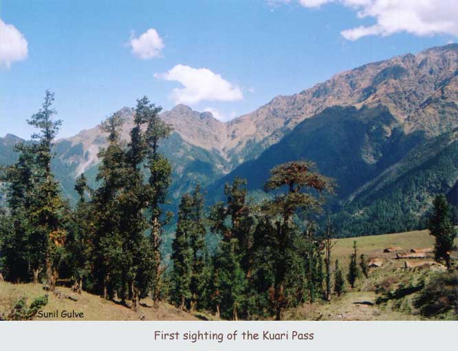
 Sartoli is a buggial from which one gets the first sighting of Kuari Pass. We
rested at an overgrazed hillock (it's the end of the grazing season, and all
buggials are in a state of overuse), snacked on the dry-fruit mix, which is a
wonderful high altitude pick-me-up, and gazed at our destination, beyond the
treeline on the next range.
Sartoli is a buggial from which one gets the first sighting of Kuari Pass. We
rested at an overgrazed hillock (it's the end of the grazing season, and all
buggials are in a state of overuse), snacked on the dry-fruit mix, which is a
wonderful high altitude pick-me-up, and gazed at our destination, beyond the
treeline on the next range.
 An hour's walk through deep forests (including thick bamboo groves) brought us
to our camping ground (Domabiti). A group of shepherds, on their way home, had
occupied the spot. After some sweet-talking by Rahul (and a peace offering of
aachaar to go with their lunch), they consented to move to Sartoli. This was
extremely considerate of them, since it entailed decamping, rousing their dogs,
resaddling their ponies, and moving their flock of several hundred sheep.
An hour's walk through deep forests (including thick bamboo groves) brought us
to our camping ground (Domabiti). A group of shepherds, on their way home, had
occupied the spot. After some sweet-talking by Rahul (and a peace offering of
aachaar to go with their lunch), they consented to move to Sartoli. This was
extremely considerate of them, since it entailed decamping, rousing their dogs,
resaddling their ponies, and moving their flock of several hundred sheep.
While the parleys were in progress, two rams were locking horns - rushing at each other and battering heads in a skull-splitting collision. (A renowned naturalist has claimed that this is a mating ritual devised to protect the combatants from serious injury. The blood-splattered foreheads certainly convinced me of the truth of that theory!)
 It began to rain as we pitched tents (around 1:30 p.m.). Lunch was Maggi
noodles in the big tent ( a 6-sleeper, with modified fly-sheet to withstand
Indian rains). Experienced hail for the first time. The heavens kindly relented
by late evening.
It began to rain as we pitched tents (around 1:30 p.m.). Lunch was Maggi
noodles in the big tent ( a 6-sleeper, with modified fly-sheet to withstand
Indian rains). Experienced hail for the first time. The heavens kindly relented
by late evening.
Trekking tip: Finish your walking by 1 p.m., and be settled for the night by 2 p.m., since it usually rains in the afternoons. Walking in the rain is unadvisable – visibility is poor, and the temperature falls rapidly.
Very beautiful clear night, but too cold to be appreciated. Clear nights are accompanied by stunning skies. The Milky Way is easily visible, it's that clear! We stayed indoors, playing Black Queen and Mendhicoat. Seeking a scenic squatting spot to commune with ones digestive nature was difficult, since the Bicchu Buitti (a vicious ivy) were prolific.
Dhakwani was on the next range. We had to descend, cross a gully, and ascend.
Began at quarter past eight. A winding descent to a stream took ľ of an hour (it was severely cold till we met the sun around 9:30 a.m.). Crossed it, and continued the descent through a landslide-marred path to a beautiful stream (the gully) flowing amid strawberry patches. A delightful waterfall fed this stream. The brave ones had a bath -Lakshmi and Shetal experienced their first Himalayan-dip high.
 After crossing the stream via a judiciously placed tree trunk, we began the
ascent to Dhakwani, a field of bamboo at the base of Kuari Pass. Met a shepherd
heading for Tapovan (he had started from Panha that morning, and would reach
Tapovan by evening). The ascent took less than an hour. Sartoli was visible,
and seven layers of ranges behind it.
After crossing the stream via a judiciously placed tree trunk, we began the
ascent to Dhakwani, a field of bamboo at the base of Kuari Pass. Met a shepherd
heading for Tapovan (he had started from Panha that morning, and would reach
Tapovan by evening). The ascent took less than an hour. Sartoli was visible,
and seven layers of ranges behind it.
 Dhakwani is an important acclimatizing halt, and we rested a day before heading
for the Pass. The water source was a stream running through a gorge close by.
On the other side of the gorge were caves where the ponies rested. Kuari Pass
wasn't visible from Dhakwani, as the rhododendron just above obscure it from
view. Clouds threatened all afternoon, but dispersed as they came over the
nearest range. The flickering fires in the caves made a pretty sight to fall
asleep to.
Dhakwani is an important acclimatizing halt, and we rested a day before heading
for the Pass. The water source was a stream running through a gorge close by.
On the other side of the gorge were caves where the ponies rested. Kuari Pass
wasn't visible from Dhakwani, as the rhododendron just above obscure it from
view. Clouds threatened all afternoon, but dispersed as they came over the
nearest range. The flickering fires in the caves made a pretty sight to fall
asleep to.
Lazed. Eight members went to the Pass and photographed away. In the evening, Deepak conducted an impressive Acupressure class. He's been working on my sprained back and Shetal's damaged knee throughout the trip, with good results.
 Left at 8 a.m. for the pass. Spotted a flock of grey-and-white pigeons flying
in unison. The ascent is scree-ridden. Reached the pass at 9:30. Symphonic
first view – an orchestra of snowy peaks.
Left at 8 a.m. for the pass. Spotted a flock of grey-and-white pigeons flying
in unison. The ascent is scree-ridden. Reached the pass at 9:30. Symphonic
first view – an orchestra of snowy peaks.
 A flat walk for half an hour (with the major arc of mountains on our left),
crossed a trickle, and perched atop a rocky outcrop (junta named it Panorama
Point) to drink in the view. Hathi and Ghoda Parbats, Nilkanth, Nanda Ghunti,
Chaukhamba, etc. A raging debate on whether Nanda Devi was the one afar –
sadly, Bill Aitken says it isn't visible from Kuari Pass.
A flat walk for half an hour (with the major arc of mountains on our left),
crossed a trickle, and perched atop a rocky outcrop (junta named it Panorama
Point) to drink in the view. Hathi and Ghoda Parbats, Nilkanth, Nanda Ghunti,
Chaukhamba, etc. A raging debate on whether Nanda Devi was the one afar –
sadly, Bill Aitken says it isn't visible from Kuari Pass.
 The painted marker at Kuari Pass reads 3565 m. The height in the official GMVN
map is over 4000 m. So much for the unerring accuracy of this, the scientific
age.
The painted marker at Kuari Pass reads 3565 m. The height in the official GMVN
map is over 4000 m. So much for the unerring accuracy of this, the scientific
age.
Continued on the flat walk, then an hour's descent to the treeline along a lush, carpeted meadow (Khullara). A path laid in stone leads down to Tapovan. We camp a half hour into this route, in a clearing among pines. Madhu and me suddenly feel the effects of the altitude change, and the fatigue hits us as we reach camp around 1 p.m.
Trekking tip:
Altitude sickness can affect one anywhere beyond the treeline (if trees wont
hang around there, surely we shouldn't either - after all, they're much smarter
than us). Hence the advisability of acclimatizing periodically, as at Dhakwani.

The campsite provides a wonderful view of Nanda Ghunti, with the veil being itself veiled and unveiled by clouds. A gentle stream flows nearby, with grey wagtails cavorting. Tents are placed to face the everchanging moods – opening eastwards.
The night was freezing cold. Awoke to find ice condensed on the tents. The sun arrived early, and one could thaw. Until then everyone huddled around the fire provided by the ponymen(muleteers). They keep the fire going all night and take turns minding the ponies (mules)(khacchars).
Began the knee-jerking, toe-crunching descent to Tapovan a little after 8. (I did this descent in 1983, and recall rushing down in youthful abandon. I paid for my folly nineteen years later – even two knee-bands and the crutch of a bamboo stick couldn't mitigate the agony.)
 The path runs along a stream, through a glorious pine forest. Huge root systems
create a natural stairway (the roots also prevent soil erosion – if it wasn't
for them, Tapovan would be buried in silt). The forest ends at village Regdi.
It was 11:15, and we began our last leg to Tapovan. Inhaled the stench of
civilization at 12:45. Had chai and biscuits and juicy apples (courtesy the
foraging Keri) at the jeep stand, and switched to sandals for the rest of the
trip. The Dhauli Ganga flows past Tapovan, which also boasts of a hot water
spring.
The path runs along a stream, through a glorious pine forest. Huge root systems
create a natural stairway (the roots also prevent soil erosion – if it wasn't
for them, Tapovan would be buried in silt). The forest ends at village Regdi.
It was 11:15, and we began our last leg to Tapovan. Inhaled the stench of
civilization at 12:45. Had chai and biscuits and juicy apples (courtesy the
foraging Keri) at the jeep stand, and switched to sandals for the rest of the
trip. The Dhauli Ganga flows past Tapovan, which also boasts of a hot water
spring.
Three jeeps to Joshimath (Rs. 150 for us tourists, though Rs. 100 is the usual rate), with a halt outside Tapovan to gaze at Nanda Devi. At Joshimath, we parked at Hotel Sriram, next to the GMVN office. Haggled for Rs. 1000 for 12 beds (4 rooms). Said our goodbyes to Gyan and Co.
 Eight leave for Haridwar early. Four of us (Deepak, Uddhav, Lakshmi, me) stroll
around Joshimath for a while, and take a 10 am savari jeep for Chamoli (Rs. 35
per). Road widening slows us, and we reach Chamoli at 12:15. L and I switch to
a Gopeshwar-bound jeep (Rs. 10 per), while D and U head for Srinagar (their
destination is Uttarkashi, where they plan to team up with Gyan and head for
Gaumukh-Tapovan).
Eight leave for Haridwar early. Four of us (Deepak, Uddhav, Lakshmi, me) stroll
around Joshimath for a while, and take a 10 am savari jeep for Chamoli (Rs. 35
per). Road widening slows us, and we reach Chamoli at 12:15. L and I switch to
a Gopeshwar-bound jeep (Rs. 10 per), while D and U head for Srinagar (their
destination is Uttarkashi, where they plan to team up with Gyan and head for
Gaumukh-Tapovan).
-- Dr. Jogesh Motwani