
The Elevation command changes the Elevation of track End-Points.
An End-Point can have one of several Elevation types:
Note: Each End-Point can have only one of these attributes. For example, an End-Point can not be a Defined Elevation and a Station at the same time.
In this command, Defined Elevation End-Points are indicated on the layout by Gold colored dots. Ignored Elevation End-Points are indicated by Blue colored dots.
When an End-Point is selected on the layout by Left-Click, it is highlighted by a large Red dot and its Elevation type and values are displayed in the dialog.
Shift-Left-Click splits the track at the specified point to add an Elevation point to the middle of a track.
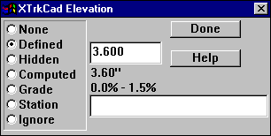
The grade at the specified End-Point is displayed next to the Grade radio button. For Defined Elevation End-Points, the grade on each side of the End-Point is displayed.
Defined Elevation End-Points are used to specify fixed heights of track End-Points. Typically, this would be where grade changes or where clearances must be maintained. Between Defined Elevation End-Points you can place Computed Elevations and Grade markers. These values are not entered directly but are Computed Dynamically based on the Defined Elevations of connected tracks. This allows you label elevations at intermediate End-Points without having the enter specific values. You can also place Computed markers between a Defined Elevation point and the end of a track.
Stations are used to provide information for the Profile command.
All Elevation (including Grade and Station) labels are drawn on the layout outlined in boxes. These may be moved by the Move Label command. In addition, Grade labels have an arrow indicating the upwards direction.

The Tools Menu contains commands to Remove or Raise/Lower the Elevations from selected tracks. The entered value is added to all Defined Elevations on Selected tracks. A negative value will lower the Elevations.
Elevations of Tracks are computed in following steps. The colors listed in each step are used as the background color of the Track Elevation Markers (if they are enabled).
The Elevation Computation is performed incrementally every time the layout is changed to keep all Elevations in sync. The performance of the computation is affected by the placement of the Defined Elevation End-Points and the number of Paths between them. Place the Defined Elevations at points where tracks begin to branch (such as the throat of a yard or at the ends of a siding). Also, use Defined Elevations to break the layout into areas so recomputation has fewer tracks and Paths to deal with.