
A deep ravine connects the hills with the creek to serve as the southwestern boundary of the campground. To the northeast is the "defile of hills," first written of by Rufus B. Sage. This defile is formed by two circular hills of rock about seventy-five yards apart. Through them the old trail used to wind on its way up the long, gradual hill toward Black Forest. Part way up this hill, not very far from the remaining traces of the old trail, is an upper spring that is half-hidden in a group of trees. A rusty pipe leads from this spring to an abandoned water tank and corral. Nearby is the shell of a story-and-a-half frame house. This house was probably built after the turn of the century as there is evidence of wooden lathes once used in plastering.
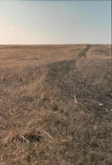
Not much is left of the old trail that once passed through Jimmy Camp. It is easy enough to trace its route on the old 1866 survey maps; but physical evidence is much harder to come by. Present ranch roads cover parts of the trail. Here and there are swales: gentle depresions that now mark the terrain where once wagons passed. Perhaps the clearest evidence of the old trail is on the gentle slope that leads north out of the vally. Here the steel-rimmed wagon wheels long ago cut into the soft earth, creating deep ruts, and starting the process of erosion that has resulted in the many ravines which scar the hillside to this day. No historical marker remains today to point the way to Jimmy Camp. The bronze plaque, which had been attached to a 3,000 lb. granite boulder and placed at the side of Highway 24 in 1949, is thought to have disappeared sometime in the mid-1970's. This plaque had been erected by the Kinnikinnik Chapter of the D.A.R. in cooperation with the Colorado Springs Pioneers' Association and the Colorado State Historical Society. It had read in part: A couple miles to the south of Jimmy Camp, across Highway 94, the old boxcar still sits atop Jimmy Camp Bluffs. On the northeast end of these bluffs is a sandstone formation known as Balanced Rock. Into its sides are carved several names from the 1880's and 90's. Most of these names were probably inscribed by 19th century coal miners from the nearby site of McFerran. Among the more legible names are: M. Baujet 1884...H. Newcomb 1890...M. Garet 1887...Jack Asbaugh M.D. 1895...Hutchison 1888...Art Simshauser
"One mile southeast...is the site of Jimmy Camp, named for Jimmy (last name undetermined) an early trader who was murdered there. A famous campsite on the trail connecting the Arkansas and Platte rivers and variously known as Trappers' Trail, Cherokee Trail, and Jimmy Camp Trail. Site visited by Rufus Sage (1842), Mormons (1847), and many goldseekers in 1858-59."
©1999 2000 Richard Gehling
E-mail me.