
The transatlantic track of Columbus's first voyage
Christopher Columbus departed on his first voyage from the port of Palos (near Huelva) in Spain, on August 2, 1492, in command of three ships: the Niña, the Pinta and the Santa Maria. Columbus called first at the Canary Islands, the westernmost Spanish possessions. He was delayed there for four weeks by calm winds and the need for repair and refit. Columbus left the island of Gomera on September 6, 1492, but calms again left him within sight of the western island of Hierro until September 8.
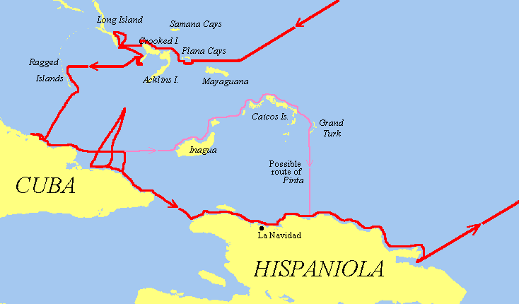
Columbus arrived at his Bahamas landfall on October 12, then proceeded to Cuba on October 28. While sailing north of Cuba on November 22, Martín Alonso Pinzón, captain of the Pinta, left the other two ships without permission and sailed on his own in search of an island called "Babeque," where he had been told by his native guides that there was much gold. Columbus continued with the Santa Maria and Niña eastward, and arrived at Hispaniola on December 1.
The flagship Santa Maria grounded on a reef on Christmas Eve and sank the next day. Columbus used the remains of the ship to build a fort on shore, which he named La Navidad (Christmas). But the tiny Niña could not hold all of the remaining crew, so Columbus was forced to leave about 40 men at La Navidad to await his return from Spain. Columbus departed from La Navidad on January 2, 1493.
Now down to just one ship, Columbus continued eastward along the coast of Hispaniola, and was surprised when he came upon the Pinta on January 6. Columbus's anger at Pinzón was eased by his relief at having another ship for his return to Spain.
The two ships departed Hispaniola from Samana Bay (in the modern Dominican Republic) on January 16, but were again separated by a fierce storm in the North Atlantic on February 14; Columbus and Pinzón each believed that the other had perished. Columbus sighted the island of Santa Maria in the Azores the next day. After a run-in with the local governor, he arrived at Lisbon on March 4, and finally made it back to his home port of Palos on March 15, 1493.
Meanwhile, Pinzón and the Pinta had missed the Azores and arrived at the port of Bayona in northern Spain. After a stop to repair the damaged ship, the Pinta limped into Palos just hours after the Santa Maria. Pinzón had expected to be proclaimed a hero, but the honor had already been given to Columbus. Pinzón died a few days later.
The transatlantic track of Columbus's first voyage
The inter-island track of Columbus's first voyage
Columbus's log of the first voyage has not survived, although we do have a good abstract of it, written in the 1530's by Bartolome de las Casas. (The best English version of this work is Dunn & Kelley's 1989 transcription)
On the westward passage, Columbus kept two sets of distance figures in the log. According to Las Casas, this was done to allay the fears of the crew that they had sailed too far from Spain. In 1983, James E. Kelley suggested that the real reason for the two sets of figures was that Columbus was converting between Italian Leagues (of 2.67 nautical miles) and Portuguese Maritime Leagues (of 3.19 nautical miles). The two league measures differ by a ratio of 6-to-5, and it is significant that the two league figures in the log tend to cluster around just this ratio. In the table below, these two figures are listed as True and Reported leagues.
| Date | 'True' Lgs. | 'Reported' Lgs. | Reconstructed Lgs. | Course |
|---|---|---|---|---|
| 8-Sep | 9 | 9 | W | |
| 9-Sep | 15 day | 18 | ||
| 30 night | 36 | W by N | ||
| 10-Sep | 60 | 48 | 60 | assumed W |
| 11-Sep | 20 | 24 | W | |
| 20 | 16 | 20 | ||
| 12-Sep | 33 | less | 33 | |
| 13-Sep | 33 | 29 | 33 | W |
| 14-Sep | 20 | less | 20 | |
| 15-Sep | 27 | 32 | W | |
| 16-Sep | 39 | 36 | 39 | W |
| 17-Sep | 50 | 47 | 50 | W |
| 18-Sep | 55 | 48 | 55 | |
| 19-Sep | 25 | 22 | 25 | |
| 20-Sep | 7 or 8 | 9 | W by N, WNW | |
| 21-Sep | 13 | 16 | ||
| 22-Sep | 30 | 36 | WNW | |
| 23-Sep | 27 | 32 | NW | |
| 24-Sep | 14.5 | 12 | 14.5 | W |
| 25-Sep | 21 | 13 | 21 | SW by W |
| 26-Sep | 31 | 24 | 31 | W |
| 27-Sep | 24 | 20 | 24 | W |
| 28-Sep | 14 | 13 | 14 | W |
| 29-Sep | 24 | 21 | 24 | W |
| 30-Sep | 14 | 11 | 14 | W |
| 1-Oct | 25 | 20 | 25 | W |
| 2-Oct | 39 | 30 | 39 | W |
| 3-Oct | 47 | 40 | 47 | |
| 4-Oct | 63 | 46 | 63 | W |
| 5-Oct | 57 | 45 | 57 | |
| 6-Oct | 40 | 33 | 40 | W |
| 7-Oct | 23 day | 18 | 23 | W |
| 5 night | 5 | WSW | ||
| 8-Oct | 11.5 or 12 | 11.75 | WSW | |
| 9-Oct | 11 day | 11 | W by S | |
| 20.5 night | 17 | 20.5 | W by N | |
| 10-Oct | 59 | 44 | 59 | WSW |
| 11-Oct | 27 day | 27 | WSW | |
| 22.5 night | 22.5 | W | ||
| 2 to island | 2 | |||
| Totals: | 1108.75 | 1142.25 |
| Date | Reconstructed Lgs. | Course |
|---|---|---|
| 16-Jan | 2 | E by S |
| 14 | E by N | |
| 2 | SE | |
| 12 | NE by E | |
| 17-Jan | 7 | NE by E |
| 10 | NE by E | |
| 4 | NE by E | |
| 11 | E | |
| 18-Jan | 10 | E by S |
| 7.5 | ESE | |
| 15 | N by E | |
| 19-Jan | 14 | N by E |
| 16 | NE by N | |
| 10 | NE | |
| 11 | NE by N | |
| 20-Jan | 5 | NE |
| 2.8 | SE | |
| 9 | NNE | |
| 21-Jan | 13 | N by E |
| 13 | NNE | |
| 21 | NNE 1/2 E | |
| 22-Jan | 8 | NNE |
| 4.5 | N by E | |
| 3 | NE | |
| 7 | ENE | |
| 8 | ENE | |
| 23-Jan | 21 | NE by N |
| 7.5 | NE | |
| 7.5 | ENE | |
| 24-Jan | 11 | NE |
| 14 | ENE | |
| 25-Jan | 9.5 | ENE |
| 6 | NNE | |
| 7 | ENE | |
| 26-Jan | 14 | E by S |
| 10 | SE by E | |
| 6 | N | |
| 27-Jan | 16.5 | NNE 1/4 N |
| 6 | NE | |
| 3 | ENE | |
| 28-Jan | 9 | ENE |
| 5 | ENE | |
| 29-Jan | 9.8 | ENE |
| 8 | ENE | |
| 30-Jan | 7 | ENE |
| 13.5 | N by E | |
| 31-Jan | 7.5 | N by E |
| 8.8 | NE | |
| 13.5 | ENE | |
| 1-Feb | 10.5 | ENE |
| 29.3 | ENE | |
| 2-Feb | 10 | ENE |
| 19.3 | ENE | |
| 3-Feb | 29 | ENE |
| 27.5 | ENE | |
| 4-Feb | 32.5 | E by N |
| 19.3 | E | |
| 5-Feb | 13.5 | E |
| 27.5 | E | |
| 6-Feb | 35.8 | E |
| 38.5 | E | |
| 7-Feb | 32.5 | E |
| 22 | E | |
| 8-Feb | 3 | E |
| 9 | E by S | |
| 6.8 | SSE | |
| 6.8 | SSE | |
| 9-Feb | 3 | SSE |
| 16 | S by E | |
| 5 | NE | |
| 9 | E | |
| 10-Feb | 32.5 | E |
| 24.8 | E | |
| 11-Feb | 39 | E |
| 16.5 | E | |
| 12-Feb | 19.5 | E |
| 11.5 | E | |
| 13-Feb | 6 | E |
| 7 | E | |
| 13.8 | E | |
| 14-Feb | 5 | NE by E |
| 8 | NE by E | |
| 7.5 | NNE 1/2 E | |
| 2.5 | NE | |
| 15-Feb | 13 | ENE |
| Total: | 1072.8 |
Voyage I.....Voyage II&III.....Voyage IV..... Letters..... Myths And Facts..... His Life..... His Ships.....Log.....Doors.....Bibilography.....Media.....