Name: The name Durmitor is
probably of Celtic origin and means "mountain with water"
Country: Montenegro
Biogeographical province:
Balkan Highlands
Geographical Location: In
the northeast of the Republic of Montenegro. Lies approximately30 km to the south west of
Pljevlja and 30km north of Niksic. Lake Pivsko runs from north to south 5km from the
western border, and the village of Zabljak is located close to the north eastern border.
It spreads between rivers Tara, on the north, and Piva (Bukovica, Komarnica and Piva lake)
on the west and south and foothill of Sinjavina on the east. The highest peak on the
Durmitor is Bobotov kuk - 2523m.
Date and history of establishment: 1952 as a national park. Inscribed on the World Heritage List in
1980.
Area: 32.000 ha
Altitude: 450 to
2.523 m
Physical Features: Durmitor
National Park comprises Mount Durmitor plateau and the valley formed by the canyon of the
River Tara, incorporating three major geomorphological features: canyons, mountains and
plateau, ranging in elevation from about 450 - 2.523 meters. Because of its geographical
location and range in altitude, the 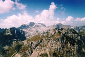 park is
under the influence of both Mediterranean and alpine micro climates which has resulted in
an exceptional range of species. Geologically, Durmitor and Tara canyons are made up of
rocky massifs of the secondary area (from the lower Triassic to the upper Cretaceous),
tertiary and quaternary areas. The dominant features are the limestone formations of the
middle and upper Triassic, the upper Jurassic and the upper Cretaceous, especially the
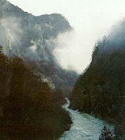
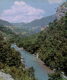
so-called Durmitorean flysch. The river Tara, on of the last wild rivers in Europe, has
pure, clear waters, a gorge of 1.300m depth and notable floristic and faunistic diversity.
The 16 glacial lakes of the Durmitor and the canyons of the Tara, Susica and Draga rivers
were formed during the Quaternary period, following the sudden thaw of the snow and the
formation of glaciers on the Durmitor and neighboring mountains. The water of the largest
lake, Black Lake (Crno jezero), feed two separate river basins: the river Tara, and
underground through the DurmitorĀ massif to the river Komarnica or Piva. Durmitor,
this natural link between earth and sky, the Athos of Montenegro, first ecological state
in the world, offers you: 18 lakes, 5 canyons, 27 peaks above 2200 meters, 48 peaks above
2000 meters, 748 sources of potable waters, forests over 500 years old, 2000 km of marked
foot paths and climbing paths. park is
under the influence of both Mediterranean and alpine micro climates which has resulted in
an exceptional range of species. Geologically, Durmitor and Tara canyons are made up of
rocky massifs of the secondary area (from the lower Triassic to the upper Cretaceous),
tertiary and quaternary areas. The dominant features are the limestone formations of the
middle and upper Triassic, the upper Jurassic and the upper Cretaceous, especially the
so-called Durmitorean flysch. The river Tara, on of the last wild rivers in Europe, has
pure, clear waters, a gorge of 1.300m depth and notable floristic and faunistic diversity.
The 16 glacial lakes of the Durmitor and the canyons of the Tara, Susica and Draga rivers
were formed during the Quaternary period, following the sudden thaw of the snow and the
formation of glaciers on the Durmitor and neighboring mountains. The water of the largest
lake, Black Lake (Crno jezero), feed two separate river basins: the river Tara, and
underground through the DurmitorĀ massif to the river Komarnica or Piva. Durmitor,
this natural link between earth and sky, the Athos of Montenegro, first ecological state
in the world, offers you: 18 lakes, 5 canyons, 27 peaks above 2200 meters, 48 peaks above
2000 meters, 748 sources of potable waters, forests over 500 years old, 2000 km of marked
foot paths and climbing paths.
Durmitor consist of:
- the mountain mass - the mountain wreath above 2.000m and heights and valleys among them;
- lower parts of the mountain (around 1.400m altitude): Jezera, Drobnjak and Pivska
planina;
- canyon valleys of rivers Susica, upper course of Komarnica, the Grabovica and the spring
part of Bukovica.
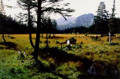
The lower part of Durmitor mass is covered with
conifer wood (juniper bush, fir tree and white pine tree) and deciduous trees. The valleys
are covered with rich pastures. On the funnels and foothills some interesting kinds of
flora can be found (rare relictnic and endemic species). Chamois, bear, wolf, eagle and
big grouse are not rare animals. The special characteristic of Durmitor are its lakes,
pools, puddles, underground streams and springs.
more photos
from Durmitor
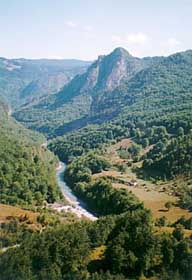
THE TARA CANYON - THE TEAR OF
EUROPE
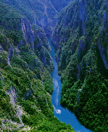 A fast and
noisy river, 150 km long, it cuts trough the Montenegrin mountains a 90 km long canyon of
unequalled wild beauty. Its steeps sides rise to 1300 meters. This area is covered with
jungle vegetation which emanates a sublime harshness. It is one of the few oases of
immaculate nature, and a reservation for many species of plants and animals, some of the
endemic. All this has contributed to this canyon, second in size in the world (after the
Grand Canyon in Colorado), and Durmitor wit it, being protected by UNESCO as part of the
world's heritage. The canyon is fall down into the depth of earth, a steep and deep line
cut between high mountains, one of the deepest gorges in the world formed by erossia, the
deepest canyon in Europe. The Tara canyon spreads from Bistrica (Crna poda) to Scepan
polje and it's about 80km long. The kanyon is cut between the mountains Sinjavina and
Durmitor on the left, and Ljubisnja and Zlatan bor on the right hand side. A fast and
noisy river, 150 km long, it cuts trough the Montenegrin mountains a 90 km long canyon of
unequalled wild beauty. Its steeps sides rise to 1300 meters. This area is covered with
jungle vegetation which emanates a sublime harshness. It is one of the few oases of
immaculate nature, and a reservation for many species of plants and animals, some of the
endemic. All this has contributed to this canyon, second in size in the world (after the
Grand Canyon in Colorado), and Durmitor wit it, being protected by UNESCO as part of the
world's heritage. The canyon is fall down into the depth of earth, a steep and deep line
cut between high mountains, one of the deepest gorges in the world formed by erossia, the
deepest canyon in Europe. The Tara canyon spreads from Bistrica (Crna poda) to Scepan
polje and it's about 80km long. The kanyon is cut between the mountains Sinjavina and
Durmitor on the left, and Ljubisnja and Zlatan bor on the right hand side.
On the canyon sides there are isthmuses-clifs, rocky
hillsides, spread stony heads and depressions which cut across mountain sides. The Tara
canyon is deepened by the river erossia and denudation; it is designed by lonely pine
trees and also by conifer woods.
|