Monday, May 7, 2001, 5:30 a.m. - Mile 0 - Pleasanton, CA
I can't sleep anymore. I'm reminded of the old joke: "Talk about insomnia, I can't even sleep when it's time to get up!" I no longer think it's funny, since more often than not that's the case with me.
I had considered leaving about 10:00 a.m., after the morning rush hour traffic had cleared, but leaving before 6:00 will give me four additional hours and get me much further down the road before I have to stop for the night. The car is loaded, the top is down, and I'm ready to go.
There's a full moon out, which is just setting, and I can see the first hints of light in the east. Since I really don't enjoy driving the S2000 on freeways, at least not at legal speeds, it's my goal to avoid driving on freeways as much as possible.
I head out of Pleasanton and take the frontage road along the 580 freeway towards Hayward. Since I really don't know a proper route through Hayward, I get on the freeway and take 580, 238, and 880 to 92, which crosses San Francisco Bay and goes over the Santa Cruz mountains, all the way to the coast at Half Moon Bay.
Traffic on the San Mateo Bridge is moving slowly up to the toll booth, but at least it's moving. Once I'm past the toll booth and onto the bridge traffic moves quite well. The sun has just come over the horizon and is right behind me. I have to sit a bit taller or shorter to keep from being blinded by the mirrors.

The morning rush hour traffic hasn't been that bad and now I'm heading up over the Santa Cruz mountains on Highway 92. It's colder in the mountains, but I can smell wild flowers and the forest and I can hear the birds as I drive along. I stop at the summit where Highway 92 meets 35, to listen to the birds and enjoy the morning for a few minutes. This is a perfect day.
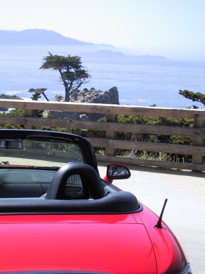
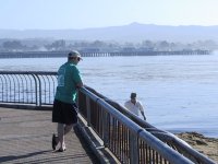
6:50 a.m. - Mile 44.3 - Half Moon Bay
I stop at the Half Moon Bay Fish Market, which I've decided will be the official start and end of my trip. This is where a bunch of Bay Area S2000 owners met for a drive through the Santa Cruz Mountains a couple of months ago. I usually stop here to get a shrimp cocktail when coming to the beach along this route, but they're not even open this early.
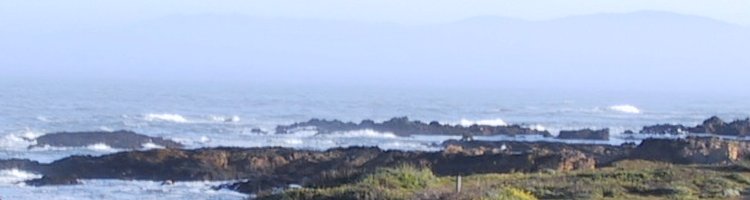
I start off down Highway 1, stopping occasionally to take pictures. At one place I want to take a picture of the cliffs next to the ocean. I accidentally get a little closer to the edge than I'm comfortable with at one spot where the erosion has cut away a section with tall plants on both sides. I've got to be a bit more careful.
Here is where I break the first of many resolutions I've made for the drive. I had hoped to keep the engine under 6,000 rpms, but I go into VTEC mode while pulling away from a stop. This resolution gets totally ignored the further I get into the trip, especially while passing traffic on 2-lane roads. The power from 6,500 to 9,000 rpms is addictive like a drug.
I've also resolved to stay within 9 mph of the speed limit. I find during the trip that I'm much better at this in most places. I have to use the cruise control on the Honda on the open highway to keep from going faster, though. It's an absolutely beautiful morning.

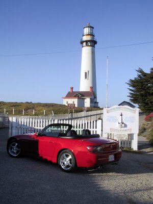
8:00 a.m. - Mile 94.8 - Santa Cruz

I stop on the north end of town in Santa Cruz to take a few more pictures. The weather is calm and about as perfect as can be. At this point I'm heading south and the sun is in the southeast. Time to put the hat on. I really don't like wearing a hat, but it's the only kind of visor that really works in a car like this. I clean off the ocean mist from the mirrors, and a few bugs from the windshield.
I stop at the Mark Abbott Memorial Light House to watch the surfers for a few minutes. This is a top surfing spot where surfers can ride a wave a long ways if they catch the right one. I see very few good waves while I'm watching. However, I do see a mother whale and her calf out in the kelp not too far away. I miss getting any pictures, though.

The sun is out and it's time to apply some sun screen. I drive out to the end of the pier in Santa Cruz, take a few more pictures, then stop along the Boardwalk for still more pictures. I have only a minor problem finding my way out of Santa Cruz. Some day I must get a map and study the correct route from the pier back to Highways 1 and 17.I continue on south towards Monterey.
9:45 a.m. - Monterey

I love visiting Monterey. I stopped by Fisherman's Wharf and drove through Cannery Row. I wanted to take a picture in front of the Monterey Bay Aquarium, but there wass a large crowd waiting to get in and nowhere that it's even legal to stop anywhere in front of it. I decided I'll have to skip this one. I drove slowly towards 17-Mile Drive, along some of the most beautiful coastline I've ever seen. (After driving the entire Pacific Coast, I still think this is the most beautiful spot on the coast.)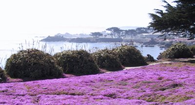
10:15 a.m. - Mile 152.0 - 17-Mile Drive

It costs $8.00 to enter 17-Mile Drive, which is all private property. The attendant likes the car. I enjoy most of the scenery from the car, stopping only a few times to view special things. This is not really the best way to see such areas, but I do a lot more "quick viewing" of places that should be viewed with plenty of time available. My main goal of this trip is to drive the car, not view scenery, right?11:00 a.m. - Mile 161.2 - Highway 1 south of Monterey
Once you exit the 17-Mile Drive, you're on Highway 1 southbound, the Pacific Coast Highway, for hundreds of miles. There are a few places to stop for lunch or gas, but not many. Traffic is fairly light, but there are still some slow cars and motorhomes that can be difficult to get around. I get by a few particularly slow ones and have a clear road in front of me. There are few good places to pass on Highway 1, even with a car like the S2000 that has very good acceleration. I don't want to stop, even for a quick picture, and give the slow guys a chance to get back in front of me again.12:25 p.m. - Mile 239.7 - Lunch on Highway 1
I eventually get hungry enough (and have to go to the bathroom), so I stop for lunch at one of many overpriced cafes I'll visit on this trip. I should have stopped sooner, but a clear road in front with slow cars behind made me not want to stop.I notice that the rechargeable battery for my digital camera is already low. I must have left it on during one section. I have a non-rechargeable battery to use when the other one is used up, but it will get expensive if I use many of those.
At 241 miles, the gas gauge shows zero "bars" on it as I head back out onto Highway 1 from lunch. The gauge goes back up to 1, then 2 bars, but I'm watching for a place to fill up.
At this point I wonder why Pontiacs seem to be over-represented as slow cars blocking they way. Is it because of the "We build excitement" advertisements attracting boring people to their cars, hoping to somehow become exciting? I don't know, but I dread getting behind Pontiacs, Volvos, and anything with a diesel engine.
The sun is really starting to beat down, time to wear long sleeves. I put on a loose shirt and wear a hat to keep the sun from burning me.
Mile 278.6 - Gas stop in Cayucas
At Pismo Beach, Highway 1 splits off from 101. I go through town and end up on what I think is Route 135, the wrong road. I figure out I'm headed north and turn around, going about 13 miles extra. I'm still not on the right road, but I get onto Harris Grade, which contains a good 35 mile section of twisties before I get back to Highway 1. At mile 365, I stop in Lompoc for a cold drink and a snack. I'm back on Highway 1, where I want to be. This section of Highway 1 is a nice road and I enjoyed driving on it. Next time I'm going to get a detailed map of this section of California so that I can follow the true Highway 1 from Pismo Beach to Gavota.At one point on Highway 1 where there curves weren't so tight, a GMC S-15 pickup saved me from a sure ticket at a radar trap. I was thinking of passing him at a point with no double-yellow, but decided he was going fast enough and to just follow him. Soon after that, an instant-on Ka-Band radar signal showed up on my radar detector without enough advanced warning to slow down, but we were going slow enough to not attract the police officer's attention. If I had passed him, I would have been caught at passing speed.
There is definitely more radar used in Southern California than in Northern California.
4:38 p.m. - Mile 422.2 - Santa Barbara
It's rush hour in Santa Barbara, so traffic is slow and heavy for a while. It's basically off and on heavy traffic the rest of the day. Much of this section has afternoon fog, which keeps things cool.5:15 p.m. - Mile 457.7 - Oxnard
Highway 1 splits off of 101 again at Oxnard. I follow it along the coast through the Santa Monica Mountains. There is quite a bit of traffic here, but it is quite scenic. I spot another S2000 coming the other way north of La Jolla Canyon. It's a yellow one with the top up. I honk and wave, but the driver has other things on his mind. I determine that honking is worthless in traffic and remind myself to flash the lights if I see anymore S2000's (I see exactly one more the whole trip).5:45 p.m. - Mile 475.0 - Santa Monica
I stop along the coast for a few more pictures. I find my watch where I've packed it in my briefcase. I quit wearing a watch years ago when I found out that it contributed to a case of tendinitis that I had in my wrist. Since the S2000 doesn't have a clock, I've been having to use the clock in the digital camera to figure out what time it is. That probably contributed to the premature failure of the rechargeable battery.
It's getting colder, so I put the long sleeve shirt back on for warmth this time, rather than sun protection. I'm getting hungry.
7:30 p.m. - Mile 525.2 - Torrance
I've been driving along Highway 1, which is all businesses with regular stop lights throughout the Los Angeles area. It kind of reminds me of El Camino Real between San Jose and San Francisco, but much longer. I finally stop for dinner at a Taco Bell. The driving is slower here, but I really don't want to get on the freeway.8:00 p.m. - Mile 538.6 - Long Beach
It's finally starting to get dark. I pass many hotels that are in neighborhoods that I don't like, but finally give in and stop at a Comfort Inn at the far end of Long Beach. I'm concerned about leaving the car out in the open, but don't have much of a choice. I put the top up for the night and park next to the entrance where the night manager is more likely to notice anyone bothering the car. I put the "boot cover", or whatever you call that vinyl thing that covers the top when it's down, in the front seat for the night.I decide that I've driven too far (538.6 miles) in too many hours (16) on this day and resolve to make the remaining days shorter. This should be both the longest and farthest day of the trip. (Boy was this a naive thought!)
Previous Next Home Site Map
Copyright (c), 2001 by Scott R. Nelson
Page last updated July 9, 2001
ScottRNelson@HotMail.com