Introduction
Situated on the western edge of Sherwood forest, the town of Sutton occupies a
prominent position overlooking Derbyshire to the west. The high ground marked the boundary of a Celtic kingdom during the
Iron Age and Roman period. It is still the boundary between Nottinghamshire and Derbyshire and the long historical continuity of this boundary position has affected much of the history of the town and district.
1086 1115 1520 1530 1600 1610 1642-1649 1832 1861 1869 1877 1890 1898 1904 1905 2002
The Name
The name of the town is derived from the Anglo-Saxon words suth and tun,
meaning 'southern enclosure' - Sutton and the Ash trees which covered the region - in Ashfield. Many other Anglo-Saxon names are still preserved in the district for example the Carsic Estate which is derived from the two words Carr (a rock or wet meadow) and Sic (a furrow or water course).
1086In the great Doomsday survey of 1086, Sutton, along with neighbouring village Skegby, were part of the King's manor of Mansfield. Later both
Sutton and Skegby obtained their own manoral status.
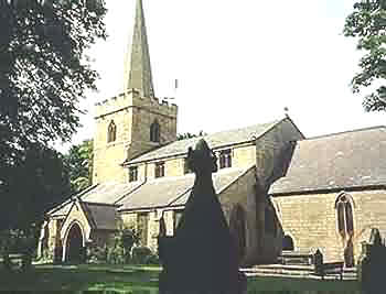
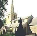
1115St Mary Magdalene Church (The Parish Church) is a Norman building first mentioned in the 12th Century. It underwent restructuring to its present form in 1868. Part of the original building has been dated by experts to 1115.
More pictures here
| 
|
1520Devonshire Square housed a Yeoman Type farm house, believed built by the Langford family in 1520, which was demolished in 1926. The roadway outside the present Library was known as 'Goodley's Hollow'.
1530Part of the mediaeval 'Great Way', between Yorkshire and Nottingham passed through the town and it was along this route that the great Cardinal Wolsey travelled when recalled to London by the king for violating a law prohibiting holding a foreign court in England.
He was stripped of all his posts and honours and later, charged with treason, again ordered back to London. On the way he became quite ill. The Cardinal lodged at Kirkby Hardwick, Hardwick-upon-Line as it was then known, which belonged to the Earl of Shrewsbury. On Friday the 25th November 1530 he rode to Nottingham, so weak that he had great difficulty sitting upon his mule. On Saturday evening (the 26th) he reached Leicester Abbey where The Cardinal died. His dying words were " Well, well, Master Kingston (Constable of the Tower) I see the matter against me how it is framed; but if I had served God as diligently as I have done the King, he would not have given me over in my grey hairs ".
1600
Around 1600 AD the Manor of Sutton was in the possession of the
Earl (later Duke) of Devonshire. A survey, dated 1610, by William Senior shows the divisions of land within the town.
1610
In 1610, most of Sutton was fields, with strict boundary field
divisions. The road now known as Outram Street swung southwards near Stoney Street and passed along the 'East Field' over the Lawn joining Forest Road (now Station Road) near Lawn Avenue. North Field (Carsic Estate), West Field, (West End and Spring Bank) East Field, (Eastfield Side and the Lawn) and The South Field (the Sutton Junction area).
1642-1649
The English Civil War (1642-1649) touched Sutton, and a number of
skirmishes were recorded. On the 3rd September 1651, King Charles II and the Scottish army were defeated at Worcester with most of his men killed or taken prisoner. Those who escaped were compelled to return home. A party of them, heading towards Sutton, had to pass along the road towards the church, which passed through a yard owned by Mr John Clark, a local farmer. He placed a barricade of ploughs across the road and 12 scottish soldiers were killed by those chasing them. In 1774, in a vault at the back of the church, 12 skeletons were found arranged as only outcasts and strangers were buried. It has been assumed that these were the remains of the Scotchmen although it has also been said that 11 skeletons were discovered beneath the surface of Westfield House, in Church Street, and moved to the church yard. After
the Civil War and the Restoration of Charles II, a spate of new building work began, which including the building of Manor House, which is still an occupied dwelling. It stands near the central Bus Station.
1832
Bull Baiting took place on the Green until 1832, Bear Baiting also took place until 1836!
1861
The first Police Station was built in the Town in 1861 at the junction of Market Street and Low street. Until recently, the site was used by the Britannic Assurance Company.
1869
The 'New Cross Inn' was built in 1869 at a cost of Ł400.00 and was originally
named 'The Dewdrop Inn'
1877
The Village Green was once known as 'Engine Green' because a building was erected there to house the Town's Fire Engine. The area was later called Portland Square, taking it's name from the Duke of Portland, who owned most of the land.
1890
The National Telephone Company introduced their system to Sutton. The call office was in a chemist shop on Portland Square owned by a Mr G.W. Briggs. An exchange was opened at 31 Victoria Street on May 8th 1906.
1898
Outram Street was extended towards the Town Centre. The lane from
there to Portland Square was known as 'Tenter Lane'. This is probably derived from the word 'Tenter' which is a common word in the textile trade. Outram Street was named after John Outram, a wealthy man from Brampton near Chesterfield, who owned land in several parts of the County.
1904
A Street Tramway ran from Mansfield, through Sutton to Huthwaite.
It opened on 1st September 1904 and ceased to operate 28 years later, when it gave way to Motor Buses.
1905
In October the Kings Theatre opened, constructed with wood and corrugated iron. It was erected by Captain Clayton, with seating for 1000 people and was later sold, together with the Grand Theatre in Mansfield, to the Mansfield, Sutton and Districts Theatre Company Ltd, a company formed entirely by local gentlemen.
2002
In February work began to improve and develope the King Mill Roundabout area of Sutton. The roundabout is being changed into a traffic light system ready for a new industrial develpoment on the old site of Sutton Harriers Training Ground and the old Hoisery Mills Football Ground. Rumours at the minute suggest a B&Q Warehouse, Hotel and Nursery School.
|