|
Where is Sutton ?
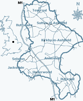
Situated at the western edge of Sherwood Forest (Robin Hood Country), 3
miles west of Mansfield, 14 miles north of Nottingham and Sheffield 24
miles to the north-west. Nearby districts of Huthwaite, Stanton Hill,
Teversal and Skegby.The town occupies a prominent position on the high Ashfield Scarp that overlooks Derbyshire
to the west. The area is served by the M1 motorway, exits 27 and 28, and the
Robin Hood Line with stations at Mansfield, Kirkby and Sutton Parkway.
|
