| |
|
July 21 , 2006
Sitka, Baranof Island, Alaska
Greetings from Sitka, where X-tra Tuff boots are known as "Sitka Slippers", the fishermen's footwear of choice! We arrived here on June 25th to find the harbor packed with fishing boats and no space available in the marina. Sitka Harbor is known for “hot berthing” meaning the Harbormaster will put your boat in a slip when a boat goes out for 24 hours, but you have to move to another slip when that boat returns. Unfortunately there were NO berths available when we arrived and we were put on a wait list. Luckily, there was space to anchor within the breakwater and we had a pleasant night in view of the marina. My uncle from Florida was arriving on the 27th for a brief visit and we had “stuff” (i.e. laundry & grocery shopping) to do before he arrived. Monday we got a slip for overnight and then had to move the boat Tuesday morning before Uncle Larry arrived, but all worked out. The harbor began clearing out June 30 th as the salmon commercial fishing season began July 1. As I write this there are slips available and the harbor is less active, but that’ll change in another week when the boats begin to return.
If you read the May Log, you know that we were in Tracy Arm, having gone up it to see South Sawyer Glacier on SV Yohelah with Teresa & Rob and Cindy & Tim. June 1 as they headed toward Glacier Bay; we decided to go back up the Arm so Gary could take more photographs. It was a beautiful bright blue day and there was no ice to deal for much of the way. We’d spent several hours going from shore to shore to see the various waterfalls when Gary decided that we should go over to “The Wall” and take a picture of me touching it while standing on the boat. The Wall is a massive slab of granite rising straight UP for several 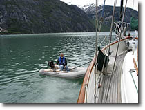 hundred feet with a depth of over 600 feet straight DOWN. Just as we were positioning ourselves, the engine quit leaving us adrift six feet from a granite wall! We quickly put fenders on both sides of the boat to protect us from bumping into the rock as we tried to figure out what had happened. We used the dinghy to pull the boat away from the wall of stone and were impressed with its ability to pull a 30-ton boat! It might make a great ad for the 4-cycle, 6 horsepower Nissan engine on the dink so we took this picture. We discovered that we had a piece of floating line and other line wrapped around the prop….sound familiar??? (See December 2005 log for the rest of the story) We were able to get the engine restarted but with a pinging sound as there must have been some hardware on the line that was hitting the propeller blade when it rotated. Traveling at a very slow rate, we were able to limp back to the anchorage at Tracy Arm Cove to further assess the damage & figure out how to clear the line. hundred feet with a depth of over 600 feet straight DOWN. Just as we were positioning ourselves, the engine quit leaving us adrift six feet from a granite wall! We quickly put fenders on both sides of the boat to protect us from bumping into the rock as we tried to figure out what had happened. We used the dinghy to pull the boat away from the wall of stone and were impressed with its ability to pull a 30-ton boat! It might make a great ad for the 4-cycle, 6 horsepower Nissan engine on the dink so we took this picture. We discovered that we had a piece of floating line and other line wrapped around the prop….sound familiar??? (See December 2005 log for the rest of the story) We were able to get the engine restarted but with a pinging sound as there must have been some hardware on the line that was hitting the propeller blade when it rotated. Traveling at a very slow rate, we were able to limp back to the anchorage at Tracy Arm Cove to further assess the damage & figure out how to clear the line.
Gary realized that he was going to have to get in the water to cut the line away…now remember that there are icebergs floating in this water and he was going in with them! A few days earlier our speed transducer had stopped working so it needed to be pulled and cleaned; Gary decided if he was going to get wet with cold water, he might just as well pull the transducer at the same time and be done with it. That was accomplished with a minimum of water gushing into the boat as the transducer was pulled and the plug inserted.
He had learned some things from his dive at Sidney Spit to clear the crab-pot line and was able to deal with this line relatively quickly. I was really concerned with his ability to think and act coherently in the FRIGID water (43 degrees) as I had recently read an article about going overboard in the higher latitudes and the effects of cold water on the body. We tied a line under the stern and attached it to each side so that he could pull himself down to the prop and back up again without having to use weights to keep him down. Dressed in several layers with fins, mask, and tethered; he made eight trips down holding his breath each time, to cut away the line. On 5th trip down, I asked him what my name was to make sure that he was still coherent and aware of his surroundings; fortunately he responded correctly and I let him continue being in the cold water. (He later confided that he had almost given the incorrect name just to tease me, but decided that I might not see the humor in the situation….he was right!) As soon as he climbed out of the water, we stripped him and rushed him into a warm shower followed by hot tea and bed to warm up. After an hour or so his teeth stopped chattering!
The propeller was not damaged, but when he took his shower the sump pump malfunctioned and overheated; fortunately he did get his shower first….just another “cruisin’” maintenance job to be done another day. Upon telling this cold-water tale to a local, the gentleman responded that Gary had now been “de-wussified” as that’s what the locals say of anyone who has been IN these northern waters. Gary’s quote regarding the entire event: “The water wasn’t cold, it was damn cold!”
June 2nd we hoisted the anchor and headed for Taku Harbor, an abandoned cannery site with a state float and walkway to shore. It was foggy and we had to watch for icebergs along the way; luckily it was calm and they showed up on the radar too. As we approached the bay’s entrance, the wind was blowing 34 knots, but decreased to 18 when we approached the docks; Gary did a great job docking under adverse conditions. Taku was an interesting place and we did some hiking during the two days we spent there. There were a few buildings from the cannery and pilings from the old pier, which are intriguing.
Continuing our journey toward Glacier Bay took us next to Auke Bay, the cruisers’ harbor of choice in Juneau. The entrance to Juneau via Gastineau Channel requires going under a bridge with a clearance of only 52’, thus making it impractical for sailboats, so most boats go around Douglas Island and stay in Auke Bay, about 10 miles north of Juneau. Upon arriving at the marina, Gary backed into our outside slip saying it would make for a fast getaway and prevent us from being boxed in. Auke Bay is a pleasant area and connected to Juneau by The Bus, a local bus service that covers a large area. As always when on shore were projects to be done, in this case the shower sump pump needed to be replaced, which was accomplished with minimal difficulty as we found an exact replacement. Other maintenance included replacing the Racor fuel filters and cleaning the raw water intake.
 We enjoyed our stay in the Juneau area and received “goodie packages” from my daughter and West Marine, what a treat! Previously, we had been sharing one pair of binoculars and finally decided that we needed a second pair (Remember, one is supposed to have redundancy on a boat!) so I ordered a pair from West Marine and had it sent to us via General Delivery. We also visited the We enjoyed our stay in the Juneau area and received “goodie packages” from my daughter and West Marine, what a treat! Previously, we had been sharing one pair of binoculars and finally decided that we needed a second pair (Remember, one is supposed to have redundancy on a boat!) so I ordered a pair from West Marine and had it sent to us via General Delivery. We also visited the 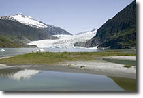 National Park at Mendenhall Glacier and the Alaska State Museum, both very impressive; but we were itching to get to Glacier Bay! We topped of the fuel tank before leaving Auke Bay and stopped at Benjamin Island Cove, Funter Bay, Swanson Harbor, Hoonah, and Pleasant Island before pulling into Bartlett Cove, Glacier Bay. In Hoonah, we saw a boat being worked on at the National Park at Mendenhall Glacier and the Alaska State Museum, both very impressive; but we were itching to get to Glacier Bay! We topped of the fuel tank before leaving Auke Bay and stopped at Benjamin Island Cove, Funter Bay, Swanson Harbor, Hoonah, and Pleasant Island before pulling into Bartlett Cove, Glacier Bay. In Hoonah, we saw a boat being worked on at the 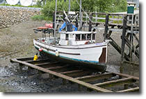 grid, a method used to get a boat out of the water when there aren’t hoists available. The boat is maneuvered onto the grid before the tide goes out and secured in place; work is then done after the tide goes out leaving the boat on “dry” land. At Pleasant Island, we were treated to five sea otters, the first we’d seen since leaving Monterey Bay in California; they’ve been making a comeback in this area we later discovered. The next day, June 16th, we’d be in Glacier Bay – two years and two weeks after leaving San Diego Bay! grid, a method used to get a boat out of the water when there aren’t hoists available. The boat is maneuvered onto the grid before the tide goes out and secured in place; work is then done after the tide goes out leaving the boat on “dry” land. At Pleasant Island, we were treated to five sea otters, the first we’d seen since leaving Monterey Bay in California; they’ve been making a comeback in this area we later discovered. The next day, June 16th, we’d be in Glacier Bay – two years and two weeks after leaving San Diego Bay!
We were surprised to hear Teresa and Cindy on the VHF when we entered the bay as we thought they had been out of the area for a week. We hailed them and discovered they’d been lucky enough to get a second permit and extend their stay for another week. We quickly heard their recommendations and then headed into Bartlett Cove for our orientation and lunch at the lodge. A rainbow, whales and sea otters greeted us as we passed the park boundary - a portent of the week to come! Private boaters are required to have a permit (no cost) and receive a brief orientation before navigating in Glacier Bay. Supposedly there are only 25 pleasure boats in the bay at one time and only 2 cruise ships per day; however, we saw four cruise ships one day. The purpose for limiting the number of vessels is to protect the environment and animals. The National Park’s staff was very helpful and informative regarding our questions. It was hard to believe that we were FINALLY in Glacier Bay as it had been our “destination” since leaving southern California.
Glacier Bay National Park and Preserve is a very special place that has changed dramatically in the past 300 years. Hoonah Tlingit lived in this area and consider it their spiritual homeland. Geological changes are occurring daily as the glaciers thin and retreat or thicken and grow. There are different types of glaciers: valley, piedmont, hanging, and tidewater, all of which are present here. When Vancouver first saw this area the entire bay was filled with glaciers and the park has documented the retreat of the glaciers over time. As the seawater reaches a tidewater glacier, it erodes the glacier’s face with its waves and tides cause the glacier to calve or break off into what becomes an iceberg. Several of the tidewater glaciers have receded so much that they are no longer calving into the sea. Endangered humpback whales frequent this area and certain waters are designated as “Whale Waters” with restriction for boaters. There are also areas that are totally off-limits as they are critical seal habitats and others that are reserved for non-motorized boats. More information about the park can be found at www.nps.gov/glba.
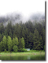
 On the way to our first night’s anchorage at Fingers Bay we were “helped” along by the flood tide and clocked 10 knots (momentarily) as our speed over ground - that’s really moving for us! The anchorage was surrounded by mountains and we watched a black bear amble down the shore after dinner as we fine-tuned our itinerary for the rest of the week. On the way to our first night’s anchorage at Fingers Bay we were “helped” along by the flood tide and clocked 10 knots (momentarily) as our speed over ground - that’s really moving for us! The anchorage was surrounded by mountains and we watched a black bear amble down the shore after dinner as we fine-tuned our itinerary for the rest of the week.
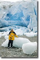
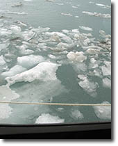 The week’s weather was far from optimum, but did not limit our navigation and we were definitely glad to be in the pilothouse. There are a limited number of anchorages because the depth of the water makes anchoring challenging. It’s difficult to get enough scope down when the water is over 100’ deep, which it is in most places! It’s easier to use a suitable anchorage as a base and explore the glaciers during the day, returning to the base at night. On Saturday we used Reid Inlet for our first exploration base and found it a little challenging to get into, as the mouth of the inlet was full of bergie bits that required careful piloting to avoid them. Our anchor site was about a mile from the face of the glacier and we were treated to a humpback whale swimming in the inlet and spouting. The glacier was impressive when viewed from the boat but when we took the dink ashore it was massive. I had a high anxiety level approaching it, as my mind was imagining what would happen if it calved while we were in the dink and a large wave was generated. My fears were unfounded and we discovered that due to melt, Reid Glacier is no longer a true tidewater glacier. It was overwhelming to be close to so much ice and to walk on stones that may never have been walked on by another human being. While anchored in Reid Inlet Teresa & Rob had seen a bear and we were also hoping to see one (but not up close & personal!) As we were walking on the sand, Gary spotted a fresh bear print and it was HUGE! We never did see the bear that made the print. It’s difficult to grasp the vastness of this environment until one has a point of reference as shown in this series of pictures. The humpback whale returned to the inlet in the evening and we enjoyed watching it as we ate dinner; definitely hard to top our floating restaurant anchored in front of a glacier with humpback whales swimming by! The week’s weather was far from optimum, but did not limit our navigation and we were definitely glad to be in the pilothouse. There are a limited number of anchorages because the depth of the water makes anchoring challenging. It’s difficult to get enough scope down when the water is over 100’ deep, which it is in most places! It’s easier to use a suitable anchorage as a base and explore the glaciers during the day, returning to the base at night. On Saturday we used Reid Inlet for our first exploration base and found it a little challenging to get into, as the mouth of the inlet was full of bergie bits that required careful piloting to avoid them. Our anchor site was about a mile from the face of the glacier and we were treated to a humpback whale swimming in the inlet and spouting. The glacier was impressive when viewed from the boat but when we took the dink ashore it was massive. I had a high anxiety level approaching it, as my mind was imagining what would happen if it calved while we were in the dink and a large wave was generated. My fears were unfounded and we discovered that due to melt, Reid Glacier is no longer a true tidewater glacier. It was overwhelming to be close to so much ice and to walk on stones that may never have been walked on by another human being. While anchored in Reid Inlet Teresa & Rob had seen a bear and we were also hoping to see one (but not up close & personal!) As we were walking on the sand, Gary spotted a fresh bear print and it was HUGE! We never did see the bear that made the print. It’s difficult to grasp the vastness of this environment until one has a point of reference as shown in this series of pictures. The humpback whale returned to the inlet in the evening and we enjoyed watching it as we ate dinner; definitely hard to top our floating restaurant anchored in front of a glacier with humpback whales swimming by!


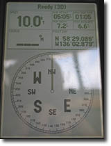
The next day we were ready to pull the hook and go exploring. Off we headed to Tarr Inlet to see the Margerie Glacier, only to discover a huge cruise ship and small powerboat sitting in front of it. We joked that SV Wand’rin Star was going to be in 5,000 pictures as we contacted the bridge of the cruise ship to advise them of our movement and passed between the glacier and the cruise ship, with passengers snapping pictures. These pictures of the glacier and cruise ship help to show the scale of space here in Alaska. Another cruise ship passed us on  our way to Lamplugh Glacier, but we had the glacier to ourselves when we arrived. We positioned the boat, turned off the engine, and just sat quietly drinking tea in front of the glacier….pretty incredible! At 11:30 a.m. ADT we reached the northernmost point of our trip at 59° 02.922N, 137° 02.981W; Gary had hoped that we’d make it to 60 ° N, but it wasn’t to be. The hook was dropped that night in Blue Mouse Cove where we met MV Daisy, a boat we knew from Point Townsend, and it was fun to compare notes with them. We had traveled 54 miles that day! our way to Lamplugh Glacier, but we had the glacier to ourselves when we arrived. We positioned the boat, turned off the engine, and just sat quietly drinking tea in front of the glacier….pretty incredible! At 11:30 a.m. ADT we reached the northernmost point of our trip at 59° 02.922N, 137° 02.981W; Gary had hoped that we’d make it to 60 ° N, but it wasn’t to be. The hook was dropped that night in Blue Mouse Cove where we met MV Daisy, a boat we knew from Point Townsend, and it was fun to compare notes with them. We had traveled 54 miles that day!
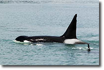 Tuesday found us heading to Muir Inlet to see more glaciers, but we never made it as we heard communications on the VHF that a pod of Orcas had been spotted near our current location. We adjusted our course so that we could parallel the pod’s movement and spend the next 3 hours watching and photographing. There were two large males, several females and an adolescent in the pod. At one point, an orca surfaced within 50’ of the stern…awesome! We dropped the lunch hook and were again treated to the Orcas as we got Tuesday found us heading to Muir Inlet to see more glaciers, but we never made it as we heard communications on the VHF that a pod of Orcas had been spotted near our current location. We adjusted our course so that we could parallel the pod’s movement and spend the next 3 hours watching and photographing. There were two large males, several females and an adolescent in the pod. At one point, an orca surfaced within 50’ of the stern…awesome! We dropped the lunch hook and were again treated to the Orcas as we got  underway after a leisurely lunch. On the way to North Sandy Cove for the night we got our first look at a horned puffin and were treated to a mother bear with two cubs as we rounded the island heading to the anchorage. We only had two more days to spend in the park and it was time to start heading south toward Bartlett Cove. The weather was cold and rainy as we entered Fingers Bay for our last night. The entrance was a favorite spot of sea otters and we saw at least a dozen as we passed. The plan to was take pictures of them the next morning as we left the bay and within an hour Gary was snapping the cute guys. The sea otters we’ve seen up here are larger than the ones in Monterey Bay. The park ranger told us that they have only been here underway after a leisurely lunch. On the way to North Sandy Cove for the night we got our first look at a horned puffin and were treated to a mother bear with two cubs as we rounded the island heading to the anchorage. We only had two more days to spend in the park and it was time to start heading south toward Bartlett Cove. The weather was cold and rainy as we entered Fingers Bay for our last night. The entrance was a favorite spot of sea otters and we saw at least a dozen as we passed. The plan to was take pictures of them the next morning as we left the bay and within an hour Gary was snapping the cute guys. The sea otters we’ve seen up here are larger than the ones in Monterey Bay. The park ranger told us that they have only been here for the last decade and that their numbers are increasing. This may be due to the fact that commercial crabbing is no longer allowed in the park and the food supply for the otters has dramatically increased. Whatever the reason for the increase, they are some of our favorite creatures. Our goal was to reach Bartlett Cove in time to have lunch at the lodge before heading to Inian Cove for the evening; the current slowed us down to 2 knots and because I thought the restaurant closed at 2:00 p.m. we had lunch on the boat instead. By a fluke of luck, we arrived at the dock at 1:50 and headed to the lodge hoping to at least have dessert before the restaurant closed. After an energizing quick walk, we arrived only to find that it was open 'til 2:30 and that we could have had lunch! Oh well, I enjoyed a delicious warm chocolate dessert and Gary had crème brulee! It’s amazing what an important part of the cruising life food is! for the last decade and that their numbers are increasing. This may be due to the fact that commercial crabbing is no longer allowed in the park and the food supply for the otters has dramatically increased. Whatever the reason for the increase, they are some of our favorite creatures. Our goal was to reach Bartlett Cove in time to have lunch at the lodge before heading to Inian Cove for the evening; the current slowed us down to 2 knots and because I thought the restaurant closed at 2:00 p.m. we had lunch on the boat instead. By a fluke of luck, we arrived at the dock at 1:50 and headed to the lodge hoping to at least have dessert before the restaurant closed. After an energizing quick walk, we arrived only to find that it was open 'til 2:30 and that we could have had lunch! Oh well, I enjoyed a delicious warm chocolate dessert and Gary had crème brulee! It’s amazing what an important part of the cruising life food is!
The next step of our journey took us to the outside of Chichagof Island into the Gulf of Alaska, the first time we’ve been in the open Pacific Ocean in several months. We shortened the time spent in the open by transiting Lisianski Inlet and Lisianski Strait, which brought us out into the ocean. We neglected to put up the sail to help dampen the rolling motion caused by the ocean’s swells and as a result the crew were “unhappy sailors” for a while. It was calmer when we entered Portlock Harbor heading to Didrickson Bay for the night. The first job was to stow the cabin stuff that had migrated to horizontal surfaces during our stay in calm waters and now needed to be stowed while we’d be in rougher water. The next day as we headed farther south, we raised the main with one reef to help dampen the roll and had a very pleasant day with 5’ swells and comfortable seas. Soon Baranof Island was visible and we were approaching Sitka.
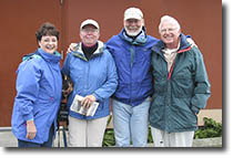 As I mentioned at the beginning of this log, my Uncle Larry and his friend, Suanne were coming to spend a few days with us before continuing their vacation with a trip to Juneau and a cruise on AmericaWest to Skagway and Glacier Bay. It was great to have guests for a few days and we took them out for night on the hook to DeGroff Bay on Krestoff Island. The weather was “typical Alaska”…rainy and gray most of the time, but we still got to see some sea otters and great scenery. Uncle Larry and I also indulged in our long-standing rivalry playing multiple games of cribbage and Scrabble…a treat for both of us! We said good-by to them on June 30th and looking forward to a quiet week or so in Sitka before continuing south to Craig and then the Queen Charlottes in British Columbia. SV Yohelah and SV Masquerade were a As I mentioned at the beginning of this log, my Uncle Larry and his friend, Suanne were coming to spend a few days with us before continuing their vacation with a trip to Juneau and a cruise on AmericaWest to Skagway and Glacier Bay. It was great to have guests for a few days and we took them out for night on the hook to DeGroff Bay on Krestoff Island. The weather was “typical Alaska”…rainy and gray most of the time, but we still got to see some sea otters and great scenery. Uncle Larry and I also indulged in our long-standing rivalry playing multiple games of cribbage and Scrabble…a treat for both of us! We said good-by to them on June 30th and looking forward to a quiet week or so in Sitka before continuing south to Craig and then the Queen Charlottes in British Columbia. SV Yohelah and SV Masquerade were a lso in Sitka and we looked forward to Independence Day with them. lso in Sitka and we looked forward to Independence Day with them.
It seems strange to think that we REALLY MADE IT TO GLACIER BAY! When we left San Diego in June 2003 it seemed like a mirage, but WE DID IT! Our new focus is to continue south and hopefully enjoy the warmth of the Sea of Cortez in November. I commented today that most of our socks are wearing thin. Gary’s reply was that soon we could throw them all away and just wear our sandals! The man is already thinking about his tan!
The journey continues….
Dorothy, Gary & Murray the Cat
Quotes for the Month
”Life is a great big canvas; throw all the paint on it you can.” – Danny Kaye
”In all things of nature there is something of the marvelous.” - Aristotle
© Copyright 2006
Last updated on
May 23, 2007
|
|
|