Memorial to Tanya Burr - Killed 15 September 2002
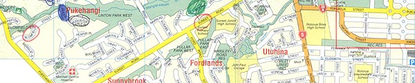
Wharekura's Map
This is the actual map of Rotorua that John Wharekura used to find his way from his friends' place in Pererika Street (at the bottom of the vertical red line) to Hilda Street, where Tanya was quietly minding her own business watching TV. The girl from the Pererika Street flat 'kindly' drew in the route he was to take in silver pen (so she could get rid of him), and you can see her line here and follow the exact route he took. This is around six kilometres and takes about 20 minutes to walk. Wharekura then walked to Hilda Street, then back to the Pererika Street flat to get the knife, and then back to Hilda Street where he knocked on Tanya's door and then killed her.
Hilda Street - the name of which is obscured by the Wharekura's (cousin?) buddy-in-crime's girlfriend's silver pen - is beside the 'F' in the word 'Fenton' in the lower right hand corner. The Hilda Street flats are on the opposite side of the road to Clouston Street, and a little below it.
The police found the map "Outside 8/15 Hilda St. in bark garden", according to the record on the front of the envelope. This was the flat behind Tanya's where Wharekura's other friends lived, and who unfortunately were away for the weekend. The map arrived in my home with a wide selection of items previously held as potential evidence and which belonged to Tanya.
![]()
The map also has a number of streetnames circled and probably they have no bearing on anything here. However, this slice of the map (showing the abovementioned silver pen line at right), also shows Tanya's original Rotorua street address - Blomfield Street - marked for some reason at the extreme left. I wonder why??