Border-Southern Tier Metropolitan Areas
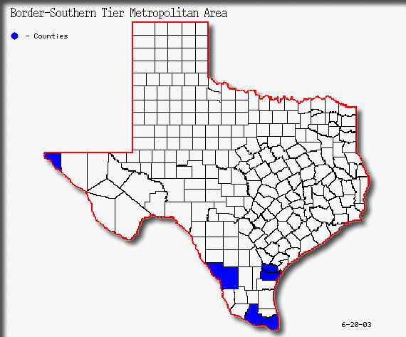
The Border-Southern Tier metropolitan areas are the fastest growing group of MSAs in the state. Table 39 shows population growth in the Border-Southern Tier metropolitan areas from 1990-2000. Those metropolitan areas along the border with Mexico saw growth rates of no less that twenty-eight percent from 1990-2000.(3) Figure 36 shows metropolitan counties in the Border-Southern Tier. This trend most likely will continue due to large numbers of immigrants from Mexico and high birth rates in the region.
Figure 36(3)
Border-Southern Tier Metropolitan Population
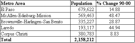
Table 39(3)
El Paso MSA
El Paso is the largest MSA of the Border-Southern Tier. El Paso consists of one county and the growth from 1990-2000 is shown in table 40. The is the western most county in the state of Texas. El Paso also is part of a larger international metropolitan area with Ciudad Jarez on the Mexican side of the border.
El Paso MSA County Population
![]()
Table 40(3)
El Paso MSA Urban Growth Patterns
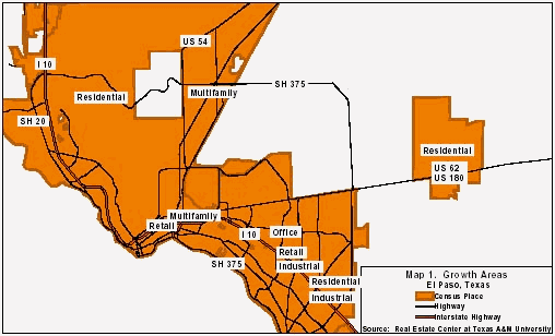
Figure 37(18)
Figure 37 shows the major growth corridors within El Paso. Industrial and heavy commercial activity is expected to continue along the border and I-10. New retail development is occurring along Zaragoza and Redd Road and at the intersection of Redd Road and I-10 on the city's west side. The west side of El Paso is one of the city's fastest-growing areas. According to the City Planning Department, the west side will have about 208,000 people by 2025. In 2000, the area had 90,600 residents. The area's growth rate is almost 50 percent more than that of the city's east side. Residential development is expected to begin in the newly annexed area bordered by Loop 375, Montana and Zaragoza on the city's east side. The city's upper-end residential market is located mostly in the city's west side, which is experiencing major growth. Some redevelopment activity is occurring in El Paso. The city is working on a $13.5 million "streetscape project" that includes landscaping, brick roadways and sidewalks. The area known as Union Plaza is part of the city's downtown revitalization project. Cities such as Socorro on El Paso's far east side are seeing rapid growth both in commercial and residential development.(18)
Population projections show a continued growth from El Paso for the next several decades. These projetions are shown in Table 41.
El Paso MSA Population Projections

Table 41(4,6)
McAllen-Edinburg-Mission MSA
This is one of the fastest growing metropolitan areas in the United States. Table 42 shows the dramatic growth of the area over the past census period from 1990-2000. This metropolitan area consists of one county. The McAllen-Edinburgh-Mission MSA was the fastest growing MSA in the state during the 1990s, growing by more than 4 percent per year. The MSA was the fourth fastest growing in the nation during this time, according to the U.S. Census Bureau. In 2000, the area’s population grew by 6.1 percent, up from 2.9 percent in 1999.(18)
McAllen-Edinburg-Mission MSA County Population
![]()
Table 42(3)
Cities within Hidalgo county have grown rapidly over the past ten years. A few of those cities are shown in Table 43.
McAllen-Mission-Edinburg MSA Suburban Growth

Table 43(18)
McAllen-Edinburg-Mission MSA Urban Growth Patterns
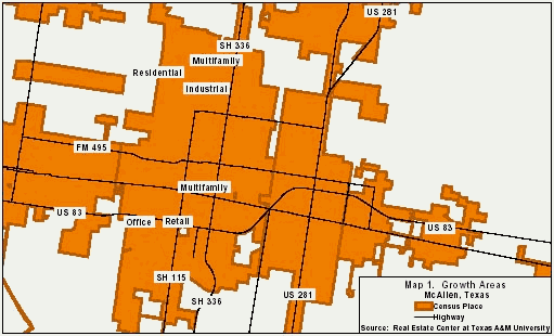
Figure 38
(18)Figure 38 shows the growth corridors in McAllen. Most residential development has been in northwest McAllen. Southwest McAllen is also growing but to a lesser degree.
Residential growth is limited in the western parts of town because of the Texas-Mexico border. Office development is occurring just north of McAllen in the eastern section of Edinburg, near the hospital. Much of the retail development is occurring in and around La Plaza Mall and along Tenth Street. Industrial growth is strongest in the Sharyland Business Park in Mission.(18) Growth in population is projected to occur for the next several decades in this MSA. Table 44 shows projections through the year 2040.
McAllen-Edinburg-Mission MSA Population Projections
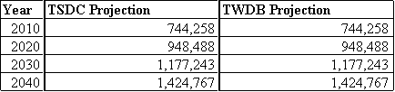
Table 44(4,6)
The MSA’s population is expected to increase by nearly 34 percent during the next ten years, or by more than 16,300 per year, according to the Texas State Data Center. The Texas Water Development Board predicts a growth rate of 3.1 percent per year through 2020. The MSA’s expected percentage growth over the next 20 years is more than double the expected growth for the state.(18)
Brownsville-Harlingen-San Benito MSA
The Brownsville-Harlingen-San Benito MSA is located at the southern-most point in Texas along the Mexican border. Cameron county is the only county in this MSA. Table 45 shows the growth in this area from 1990-2000.
Brownsville-Harlingen-San Benito MSA County Population
![]()
Table 45(3)
Brownsville-Harlingen-San Benito MSA Urban Growth Patterns
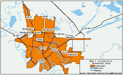
Figure 39(18)
Figure 39 shows the growth patterns in Brownsville. Retail construction has been most prevalent near Sunrise Mall. Hotels and restaurants are being built along U.S. Highways 77 and 83. Boca Chica Boulevard is also experiencing retail growth. Residential development has been occurring in every direction but has been most prominent in the north, especially at Paseo de la Resaca along FM 802.(18)
Figure 40 shows the growth patterns in Harlingen. According to Harlingen's planning director, the southwest portion of the city is the primary site of residential growth. Several recreational vehicle parks catering to winter Texans are located on the west side of the city along Hwy. 83 toward La Feria. Tropic Winds, a large, new mobile home-RV park, is located north of Loop 499. Apartment growth has primarily been small units located near the hospital.(1)
In Harlingen, medical office growth has been occurring near the hospital. Some small strip office buildings have been built throughout the city. Retail growth has been infilling throughout the city. Industrial growth is located primarily along the north of the Loop 509 corridor southeast of the airport.(18)
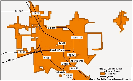
Figure 40(18)
Population projections in Table 46 show continued growth in the MSA through 2040.
Brownsville-Harlingen-San Benito MSA Population Projections
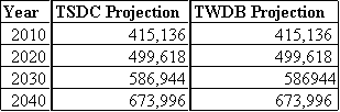
Table 46(4,6)
Between 1990 and 2000, the Brownsville MSAs population had a growth rate of more than 2.6 percent per year. In Brownsville, the MSA's fastest growing city, the majority of growth has been and is expected to continue to be in the northern portion of the city. The Brownsville-Harlingen area population is growing at a rate significantly faster than the state as a whole. That trend is expected to continue with the MSAs population predicted to grow 3 percent per year through 2020, according to the Texas State Data Center. The Texas Water Development Board predicts 2.1 percent growth per year between 2000 and 2020. (18)
Laredo MSA
The Laredo MSA was the third fastest growing metropolitan area in Texas from 1990-2000. The MSA consists of Webb county, and Table 47 details growth and population in the last census period. The metropolitan statistical area had a 2000 population of 193,117, a 44.9 percent increase since 1990. From 1990 to 2000, Laredo ranked ninth in population growth rate among MSAs across the nation. The City of Laredo's 2000 population was 176,576, a 43.7 percent increase since 1990. This growth rate was the highest among the 15 largest Texas cities. Laredo ranks 13th among those cities in total population. The Texas State Data Center projects the MSA's population will grow 7.2 percent per year through 2020. The Texas Water Development Board predicts a growth rate of 4.7 percent per year through 2020. According to the Laredo Development Foundation, the area's population is expected to exceed 230,000 in 2005 and reach 275,000 by 2010, representing a 20 percent growth rate over the five-year period.(18)
Laredo MSA County Population
![]()
Table 47(3)
Laredo MSA Urban Growth Patterns

Figure 41(18)
Figure 41 shows Laredo's major growth corridors. Growth has been occurring throughout the city according to city officials. Laredo cannot expand to the west because of the Rio Grande and the Mexico border. Industrial growth is occurring primarily in the northwest along Mines Road and near the new World Trade Bridge. Retail growth is occurring in the northern sector near the Mall Del Norte and on McPherson Road north and south of Del Mar Boulevard. Retail growth is also being seen in the south areas of the city along the frontage roads of I-35 and Highway 83. As the city's downtown revitalization efforts continue to move forward, more retail growth will be seen in the city's center. Residential growth is prevalent south of Highway 359, north of Del Mar and east of I-35. Many new residential developments in Laredo include homes in the $100,000 to $120,000 range. The Lakeside area east of the city is becoming increasingly popular among new homebuyers, especially professors from Texas A&M International University and also medical doctors. Apartment development is occurring throughout the city with new complexes on both the south and north sides. Manufactured housing makes up much of the housing in south Laredo along both sides of U.S. Highway 83. Manufactured housing communities are also located along U.S. Highway 59 and Mines Road in the eastern part of the city.(18) Population projections for the Laredo MSA are shown in Table 48.
Laredo MSA Population Projections
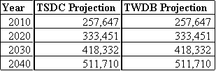
Table 48(4,6)
Corpus Christi MSA
The Corpus Christi MSA is the only metropolitan area that is not along the Mexican Border in this tier of metro areas. Nueces and San Patricio counties make up this MSA and their growth over the past census period is outlined in Table 49.
Corpus Christi MSA County Population

Table 49(3)
Corpus Christi MSA Urban Growth Patterns
Corpus Christi is primarily growing to the south and west, with the exception of industrial growth occurring in the north on North Padre Island Drive (see Figure 42). Most of the residential activity is to the south and on Padre Island, where several townhome and condominium developments are being constructed. Limited land availability prevents much expansion north and east of the city.(18)
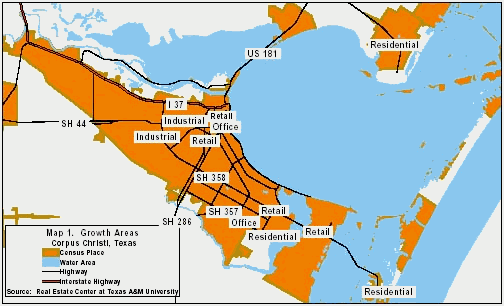
Figure 42(18)
According to the U.S. Census Bureau, the fastest growing area in Corpus Christi is the tract bounded by Staples Street, Yorktown Boulevard and Oso Creek in south Corpus Christi. Areas in north Corpus Christi have seen the greatest decline in residents because of the industrial character of the area. In 1999, Corpus Christi annexed 4.2 miles of Mustang Island's beachfront property between Corpus Christi Bay and State Highway 361. The area is mostly vacant, containing only a few condominiums. Currently, the city is seeking to annex an additional 3.2- mile section on the east side of the island between the Gulf of Mexico and Highway 361. Harbor Island is another area being prepared for development. The Port of Corpus Christi owns 350 of the island's 550 acres and intends to construct an industrial, residential or resort development. Florida-based developer Gee & Jenson has been hired to explore these options. Six acres are already occupied by the Viva Gaming and Resorts' casino cruise ship operation. Development of this island will increase the area's traffic problems. The only access to and from the island is Highway 361, which is already congested during the peak winter season.(18) Population projections for the Corpus Christi MSA are shown in Table 50.
Corpus Christi MSA Population Projections

Table 50(4,6)