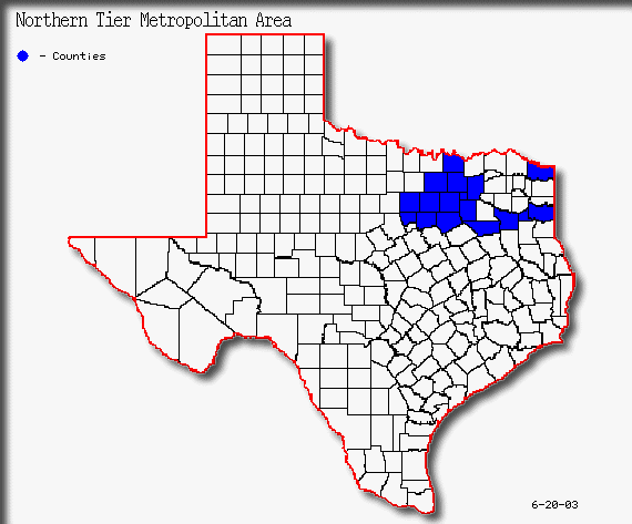
Northern Tier
The Northern Tier of Texas’ Metropolitan areas extends from Ft. Worth in the west to Texarkana in the east. Six MSAs in this tier account for the largest population total of the five tiers in this study. The following map outlines the metropolitan areas of the Northern Tier, and is followed by a table with a breakdown in population by each MSA.
Northern Tier Metropolitan Population
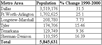
As shown in Table 1 , the Northern Tier has experienced a substantial increase in population over the census period from 1990 to 2000. The following breakdown of MSAs in the Northern Tier provides a closer look at growth trends and paterns.
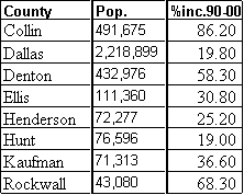
The Dallas metropolitan was the leader of growth in the Northern Tier from 1990-2000, with an increase in population of 31.5%.(3) That percent increase represents 829,306 new residents for the metropolitan area. Growth was most rapid in suburban areas to the north and east of Dallas County. Eight counties make up the Dallas MSA. Each of these counties saw growth rates of no less than 19.0% over the decade of the 90’s.
 h
h 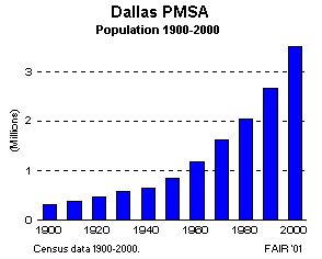 1990-2000
Table 2(18)
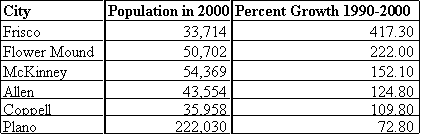
The Dallas PMSA has see steady growth for the past 100 years, as seen in figure 16. Within the Dallas PMSA are many of the states top growing counties. Collin, Denton, and Rockwall are the three fastest growing counties within the metropolitan according to data in table 2. Collin county was the 11th fastest growing county in the nation from 1990 to 2000, and Rockwall was the 28th fastest in the nation.(18) Urban sprawl continues to engulf large amounts of open land in areas such as Collin county. Frisco, once a small farm town in Collin county, grew 417.3% from a town of 6,000 residents in 1990 to 33,700 by 2000. With such an increase in population, Frisco is struggling to keep up with demand for city services and transportation infrastructures. Frisco’s story of growing pains is shared by many other once farm towns in the fringes of the Dallas metropolitan area. Table 3 shows examples of some of the suburban towns that have experienced explosive growth in the last census period.
Dallas PMSA Suburban Growth
Dallas PMSA Urban Growth Patterns
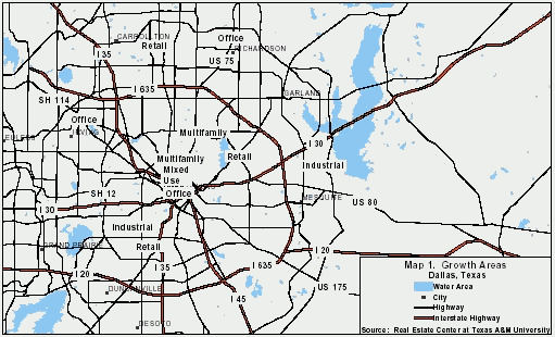
Residential development has been occurring most rapidly in Collin and Denton Counties. Retail is developing in the Plano, Frisco and Lewisville areas. The Las Colinas area in Irving and the Dallas North Tollway area have seen increasing office development. Downtown Dallas is experiencing rapid growth in the residential market with a number of renovation projects underway. Figure 17 shows Dallas' growth areas.(18)
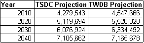
Projections for growth in the Dallas PMSA vary depending upon the state agency conducting the forecast. The following table shows population projections for the area through 2040. Two agencies are used in the table for comparison. The Texas State Data Center (TSDC), and the Texas Water Developement Board (TWDB) are the two agencies.
Dallas PMSA Population Projections
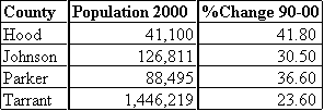
The Northern Tier’s second largest metropolitan area in population is Ft.Worth-Arlington. This metropolitan area grew by 25.1% from 1990 to 2000.(3) This increase yeiled a gain of 334,885 new residents. The largest concentration of growth occured in suburban areas on the northern side of the PMSA. The PMSA is composed of four counties, of which all saw growth exceeding 23.6% from 1990 to 2000. The following, Table 5, is a breakdown of the four counties with population statistics from the 2000 census and the growth rate from 1990 to 2000.(18)
Ft.Worth-Arlington PMSA County Population
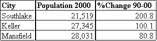
Just as in the Dallas PMSA, Ft.Worth-Arlington has seen an expansion of its suburban areas into what was farmland just a few years ago. Many of the small outlying towns have seen dramatic growth in the last decade. Ft.Worth-Arlington faces many of the same infrastructure problems as Dallas because of a struggle to keep up with population increases and urban sprawl. The following, Table 6,(18) shows examples of a few towns that have seen a transformation from rural to suburban status.
Ft.Worth-Arlington PMSA Suburban Growth
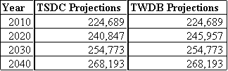
Projections show a continued pattern of growth for the Ft.Worth-Arlington metropolitan area. As in the Dallas PMSA, two projections are given for growth through the year 2040. Projections may change due to additional counties being added to the metropolitan statistical area.
Fort Worth-Arlington PMSA Urban Growth Patterns
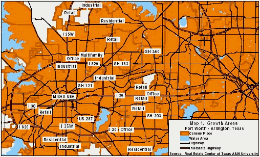
The northern portion of Fort Worth in the Alliance Airport area is the fastest growing area in the MSA. New homes, retail and industrial development are all occurring rapidly in this area. Keller, Colleyville, Southlake and Grapevine are experiencing growth in residential and retail sectors. Residential development, as well as office and industrial development, has been occurring in the southern portion of Arlington and is strongest south of I-20 (see Figure 18). Residential growth has also been occurring in the south Fort Worth, Benbrook and Cleburne areas.(18)
Ft.Worth-Arlington PMSA Population Projections
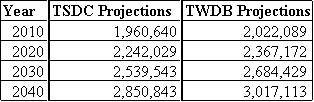
Table 7 shows that the Ft.Worth Arlington PMSA should prepare for an increase of 1.1-1.3 million more residents by 2040.(4,6)
Located in Eastern Texas, Longview-Marshall is the largest metropolitan area in the Northern Tier outside of the Dallas-Ft.Worth. This MSA follows different patterns than those of the mega-cities of North Texas. Urban sprawl is less of a factor in this smaller metropolitan area. Growth rates are much less than Dallas or Ft.Worth. The Longview-Marshall MSA consists of three counties. This area saw a 7.73% increase in population from 1990 to 2000. The total population for the MSA in 2000 was 208,780. Those counties are highlighted in the following table with 2000 population statistics.(4,6)
Longview-Marshall MSA County Population

Population projects show that the Longview-Marshall area will not grow to the extent of the North Texas metropolitan areas like Dallas. However, projections do not take into account such infrastructure changes such as a new interstate that is proposed for this area. The outcome of the Interstate-69 corridor will most likely bring growth and prosperity to this area. "It will bring great things to this area, allow goods and commerce to move easily from Mexico and Canada and all the points in between," states U.S.Senator Tom DeLay.(Abilene).(12) Because of such a change in transportation infrastucture, the figures from both the TSDC and TWDB may drastically underestimate the population growth of this MSA. The following is a table of the current population projections for Longview-Marshall through the year 2040.
Longview-Marshall MSA Population Projections
As shown in Table 9, the TSCD and TWDB do not offer a difference of opinion on the projected population of the Longview-Marshall MSA.
Longview-Marshall MSA Urban Growth Patterns
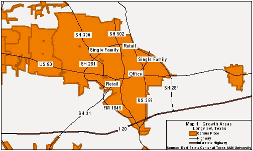
Figure 19 shows growth corridors in Longview. The primary retail corridor is along Loop 281 between Bill Owens Parkway and Judson Road. Growth is expected to continue in the industrial parks. Residential growth is concentrated in the north and northwest portions of the city. In Marshall, single-family housing growth is expected in the south and east. Retail growth is occurring along U.S. Hwy 59 near both U.S. Hwy 80 and I-20.(18)
The Tyler MSA is sandwiched between the Dallas PMSA on its western border and the Longview-Marshall MSA on its eastern border. In the 2000 census, the Tyler MSA had a population of 174,706.(3) The MSA saw an increase in population of 15.46% from 1990 to 2000. In East Texas, Tyler is currently the fastest growing metropolitan area. The Tyler MSA consists of only one county, that being Smith County. Tyler has seen an expansion southward in the past 10 years. With a continued expansion to the south, the Tyler MSA may include Cherokee County by 2020. Table 10 shows population projections with(*) and without Cherokee County.
Tyler MSA Population Projections

Tyler MSA Urban Growth Patterns
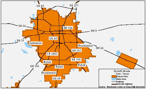
In Tyler, development is occurring primarily in the south (Figure 20), according to Tyler Planning Department officials. Retail growth is occurring along South Broadway Avenue south of Loop 323. The South Broadway corridor’s status as the leading retail district in East Texas will be underscored with the development of Tyler MarketCenter, a multitenant retail center. Retail growth can also be seen along Troup Highway. Downtown revitalization efforts are under way, with developers converting many older buildings located around the square. In the future, office growth is expected to take place on the fringe of the central business district because of zoning changes. Industrial growth is most prevalent in the industrial parks, especially south of State Highway 31 near Loop 323. Residential growth is occurring in southeast and southwest Tyler. Major residential developments are located southwest of the Grande Boulevard and South Broadway Avenue intersection, as well as south of University Boulevard. Extensive, moderately priced residential development is occurring south of the city, near Whitehouse in unincorporated areas(18)
The Texarkana MSA is one of the most complicated metropolitan areas in the state when it comes to projecting growth patterns. This MSA is located in two states, those being Arkansas and Texas. The MSA also shares a border with Louisiana and Oklahoma, which complicates things more for researchers. The Texarkana MSA consists of two counties, which are Bowie County, Texas, and Miller County, Arkansas. The MSA population as of 2000 was 129,749, an increase of 9.36% over 1990. Texarkana, as with the case of Longview-Marshall, has an unpredictable future because of new interstate construction. Interstate 69 will also run through the Texarkana MSA as it does through the Longview-Marshall MSA. In addition to the already existing Interstate-30, Interstate-49 is due for completion in the later part of 2003, and the planned Interstate-69 is scheduled for completion within 15 years.(12) Table 11 shows the population projections for the Texas side only, which is Bowie County.
Texarkana MSA Urban Growth Patterns
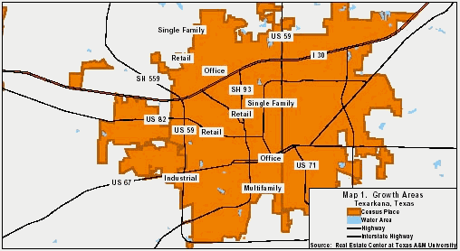
Texarkana is growing in a northerly direction. Retail and residential growth is occurring along both sides of I-30. The Richmond Road area, located in the northwest part of Texarkana, has recorded substantial new construction with a number of restaurants and retailers building in the area. Summerhill Road has experienced retail growth, and single-family growth is occurring in northern Texarkana and just south of I-30 near North Park Road. Figure 21 shows the city’s general growth and expansion areas. (18)
Texarkana MSA Population Projections(Texas Only)
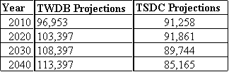
Although Table 11 only shows figures for the Texas side of the Texarkana MSA, the figures show the area to have a loss in population. I strongly disagree with the figures presented by the Texas State Data Center (TSDC). The Texas Water Developement Board also varies greatly from the projections presented by the TSDC. From 1990 to 2000 the area added nearly 10,000 new residents. With the addition of two more interstate highways, this area should see some of the greatest growth rates in the state in the coming decades.
The Sherman-Denison MSA is bordered to the south by the Dallas PMSA, and shares a border with Oklahoma on the northern side. The Sherman-Denison MSA had a population of 110,595 in 2000, which was a 16.39 percent increase from 1990. Growth in the metro area has been around Lake Texoma, which draws many Dallas area retirees, and weekend residents. Sherman-Denison MSA consists of Grayson County. Table 12 outlines project population for the metropolitan through 2040.(4,6)
Sherman Denison MSA Population Projections
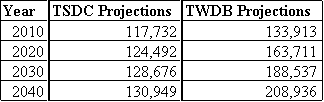
Table 12 shows a large variance on projection figures. The TSDC does not take into consideration that as the Dallas PMSA grows north, population growth will spill over into the Sherman-Denison MSA.
Sherman-Denison MSA Urban Growth Patterns
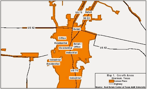
Figure 22 shows the major growth areas in the Sherman area. Retail growth in Sherman has been concentrated along the northern part of U.S. Hwy. 75 while industrial growth has been occurring along the southern portion of U.S. Hwy. 75. Residential growth has been occurring in west and northwest Sherman. Downtown Denison has seen redevelopment activity; 209 buildings have been rehabilitated over the past decade. Residential growth in Denison is happening mostly in the western part of the city, with some to the south.(18)