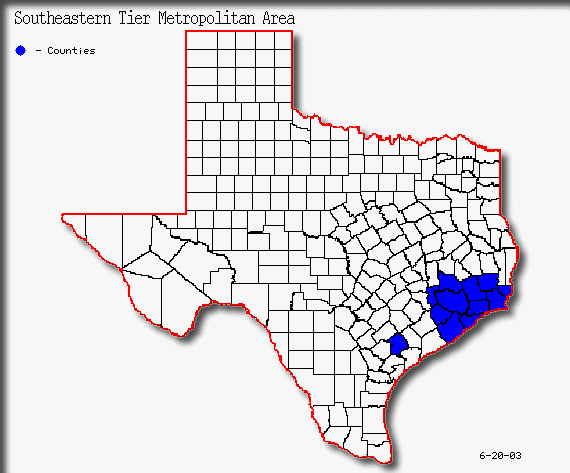
Southeastern Tier Metropolitan Areas
Figure 30
(3)Southeastern Tier Metropolitan Population

Table 27(3)
The Southeastern Tier of metropolitan areas are long the Gulf Coastal Plain in Southeast Texas. This area is the second most populated tier of metropolitan areas in this study with a 2000 population of 5.1 million. The Southeastern Tier consists of five metropolitan areas which are outlined in Table 27. Counties in the Tier are shown in figure 30.(3)
Houston PMSA
The Houston PMSA is the largest metropolitan area in the State of Texas with 4.17 million residents according to the 2000 census.(3) The Houston Metropolitan area consists of six counties. The area has seen consistent growth over the past three decades. Table 28 shows a breakdown of the counties in the metropolitan area with population and growth rate from 1990-2000.
Houston PMSA County Population 2000
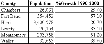
Table 28(18)
From 1990-2000 total growth for the six county area was 25.76 percent. The highest percent growth has been to the north in Montgomery County, and the largest numerical growth has been in Harris County. Substantial growth is also occurring in the western suburban areas in Waller and Forth Bend counties. Some of the cities in these high growth suburban areas are outlined in table 29.(18)
Houston PMSA Suburban Growth
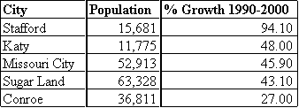
Table 29(18)
Population projections show continued growth for the Houston PMSA through 2040. Counties such as Walker, and San Jacinto will most likely become part of the metropolitan area within the next twenty years, if growth patterns continue to the north and west. Table 30 shows population projections for the Houston PMSA. Two sets of data area provided. One set is from the Texas State Data Center, and the other from the Texas Water Development Board. The population of the Houston PMSA increased at an average annual rate of 2.4 percent during the past decade. Houston grew at a rate faster than the state in the 1990s. Population projections forecast an average growth rate of 2.1 percent per year through 2020, according to the Texas State Data Center. The Texas Water Development Board predicts a growth rate of 2.3 percent per year through 2020.(4,6)
Houston PMSA Population Projections
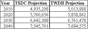
Table 30(4,6)
Houston PMSA Urban Growth Patterns
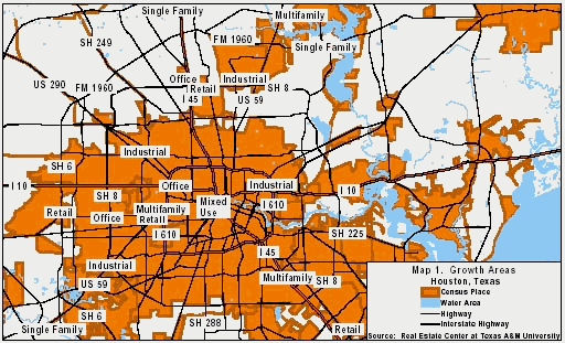
Figure 31
(18)
Figure 31 shows the major growth corridors within Houston. Strong residential growth has been occurring in Fort Bend County and in The Woodlands area, north of Houston. Apartment growth is concentrated downtown and in north Houston. Retail, office and industrial development is spread across the city. Significant retail and office development has been occurring along the Katy Freeway.(18)
Galveston-Texas City PMSA
The Galveston-Texas City PMSA is south of the Houston PMSA. This PMSA consists Galveston county. This area saw a 15.07 percent growth rate from 1990-2000, as shown in Table 31.(3)
Galveston PMSA County Growth
![]()
Table 31(3)
Growth in the Galveston PMSA has been focused in the northern part of the county around the NASA complex.
Galveston-Texas City PMSA Urban Growth Patterns

Figure 32(18)
Figure 32 shows the major growth corridors within the Galveston- Texas City PMSA. For Galveston, most of the single-family residential activity has been taking place in the east-central portion of the island, while multifamily activity has been occurring in the same area and in the island's far western portion. Retail activity in Galveston has been occurring along Seawall Boulevard and on Broadway. Some retail and single-family developments have occurred near the Texas City Mall. League City, near Clear Lake, has recorded growth in the retail, office and housing sectors.(18)
Galveston-Texas City PMSA Population Projections
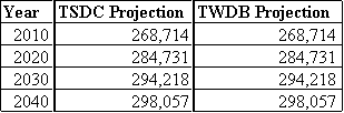
Table 32(4,6)
Beaumont-Port Arthur MSA
The Beaumont-Port Arthur MSA is the slowest growing area within the Southeaster Tier of metropolitan areas. Economic slowdown in the petro-chemical industry has slowed the growth of the area since the mid 1980s. This MSA consists of three counties and Table 33 shows growth from 1990-2000. Table 34 shows population projections for the area through the year 2040.
Beaumont-Port Arthur MSA County Population
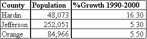
Table 33(18)
Beaumont-Port Arthur MSA Population Projections
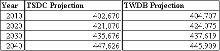
Table 34(4,6)
Beaumont-Port Arthur MSA Urban Growth Patterns
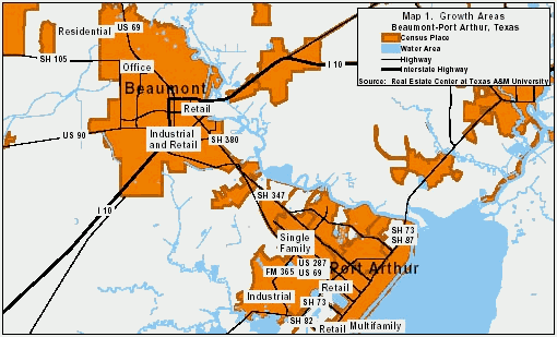
Figure 33(18)
Figure 33 shows major growth corridors in the Beaumont-Port Arthur area. Most growth in Beaumont is occurring on the northwest side of the city. Residential growth continues to the north to the Lumberton area, east to Vidor and Mauriceville and west to the Hampshire Fannett area. Retail growth is occurring around the mall on Dowlen Road, according to the City of Beaumont Development Services Department. The City of Beaumont extended Folsom Drive through to Major Drive to help accommodate expected growth in the area. Housing development has been in the northwest and southwest sections of Beaumont. Port Arthur has had significant growth in the northwestern part of the city, especially around the new Wal- Mart Supercenter and Lowe's. New housing and retail have been added. Industrial growth in Beaumont-Port Arthur has been concentrated in electrical generation and co-generation development. Several major projects will continue to enhance the industrial market, including a project in Deweyville and a project west of Beaumont. Overall, a total of eight major industrial projects are under construction or discussed in the five counties around Beaumont.(18)
Brazoria PMSA
The Brazoria PMSA consists of one county and is located to the southwest of the Houston PMSA and to the west of the Galveston PMSA. Brazoria has seen growth due to the extension of Houston suburbs into Brazoria county. This growth is on the northwestern edge of the county adjacent to Harris country. Other growth has occurred in the Lake Jackson area. From 1990-2000, the population grew by 26.11 percent as shown in Table 35.
Brazoria PMSA County Population
![]()
Table 35(3)
Lake Jackson has grown substantially since the Dow Chemical plant opened in 1940. Before then, the city was home to only a few thousand residents, mostly farmers and fishermen. By 1998, the city had grown to 26,400 people. Population growth is expected on the northern side of Brazoria County and is expected to produce growth in residential and retail development in the Pearland-Alvin area. These increases are occurring because of the new 3,320-acre, master-planned community near Pearland, according to city officials. The new community will include 12,000 new homes and will add about 31,000 people to the area. According to the Pearland Chamber of Commerce, Pearland posted 41.8 percent growth for the five-year period ending in 1998. The current population is expected to double after the master-planned community, Shadow Creek Ranch, is in place. The area will have approximately 36,000 people living in a development west of Highway 288 in the next 15 years. The Pearland and Alvin areas already account for a substantial portion of the service and retail businesses in the county. Figure 34 shows the major growth corridors within the Brazoria MSA. Most residential development has been occurring in the northern portion of Brazoria County in Pearland and Alvin.(18)
Brazoria MSA Urban Growth Patterns
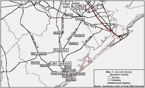
Figure 34(18)
The latest data available shows a concurrence of opinion from the TSDC and TWDB on population projections the Brazoria PMSA. Table 36 shows population projections from both the TSDC and TWDB for the Brazoria PMSA through the year 2040.
Brazoria PMSA Population Projections

Table 36(4,6)
Victoria MSA
The Victoria MSA is the smallest metropolitan area in the State of Texas. The metro area consists of Victoria county. Table 37 shows the 2000 census figures for the Victoria area.
Victoria MSA County Population
![]()
Table 37(3)
Victoria MSA Urban Growth Patterns
Residential development has been occurring mostly in the northern portion of Victoria (Figure 35). Most retail development is occurring along the Navarro corridor. Overall, new development is occurring in the north and northeast portions of Victoria, along U.S. Highway 77 and is a combination of residential and commercial growth.(18)
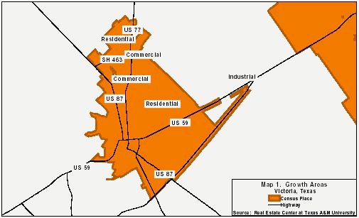
Figure 35(18)
Table 38 shows population projections for the Victoria MSA from 2010-2040. Projections from the TSDC and the TWDB are both shown.
Victoria MSA Population Projections
Table 38(4,6)