
Western Tier Metropolitan Areas
The Western Tier Metropolitan area consists of 6 MSAs. The counties in this tier are shown in Figure 43, and the population of the MSAs is show in Table 51.
Figure 43
(3)Western Tier Metropolitan Population
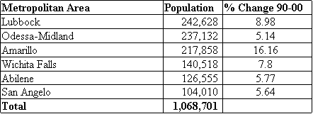
Table 51(3)
Lubbock MSA
The 2000 U.S. Census figures show that the City of Lubbock's population increased 7.2 percent from 1990 for a total population of 199,564. The U.S. Census ranks the city 11th among the 15 largest Texas cities. The City of Lubbock Planning Department unofficially estimates the city's population in 2001 to be 213,406, up 7 percent from the planning department's estimated city population in 2000.(18) The Lubbock MSA county population is shown in Table 52.
Lubbock MSA County Population
![]()
Table 52(3)
Lubbock Market Overview 2001
Urban Growth Patterns

Figure 44
(18)Figure 44 illustrates primary growth patterns within Lubbock. Much of the city's growth is occurring in the southwest, with many new residences and retail businesses built since 1994. South Lubbock has posted commercial and residential growth, especially along University Avenue and 82nd Street. Commercial growth is focused along Slide Road, Frankford Avenue, 50th Street and 34th Street. Residential developments are coming in along 34th and 50th Streets. The city's newest subdivisions are locating primarily in the growing southwest area. Ninety percent of the city's residential and commercial growth is occurring within the area from South Slide to 114th Street and from University Avenue to 82nd Street. This area is projected to be the key growth area in the future. Northwest Lubbock also is beginning to experience some growth in the residential sector, with new entry-level housing.(18) The population growth rate for the Lubbock MSA from 1990 to 2000 was nine percent, according to the U.S. Census Bureau. The city's estimate of the metropolitan area's 2001 population is 251,645. The Texas State Data Center forecasts the Lubbock MSA to have a relatively stable population over the next 20 years, growing 0.3 percent per year. The Texas Water Development Board projects that the MSA's population will grow at an annual rate of 0.7 percent.(18) Projections for growth of Lubbock MSA are shown in Table 53.
Lubbock MSA Population Projections

Table 53(4,6)
Odessa-Midland MSA
The Odessa-Midland MSA consists of Ector and Midland counties. Growth and population figures from the 2000 Census are shown in Table 54.(3) Odessa and Midland are similar in size, although Midland and Midland County are growing at a faster rate than Odessa. During the past decade, the area has grown 0.5 percent per year on average, the slowest rate of the Texas MSAs. This is the result of the decline in population experienced in 1999 when the area lost 1,676 people, more than 1,000 of whom were from Ector County, because of the downturn in oil prices. The 2000 Census finds that the area population is lower than the Census Bureau estimates for 1999. Oil prices have since rebounded substantially, which is expected to positively affect population growth in the area. The Texas State Data Center predicts a 0.5 percent growth rate each year for the MSA through 2020.(18)
Odessa-Midland MSA County Population
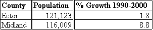
Table 54 (3)
Odessa-Midland Market Overview 2001
Urban Growth Patterns
Retail growth in Odessa is occurring along University and 42nd Street, between Grandview and East Loop 338, and along West Loop 338 near Walnut. Midland's retail growth is occurring along the loop and east toward Midland Street. Single-family growth is occurring in northwest Midland and northeast Odessa. Industrial growth has been occurring south along I-20 and between I-20 and Business 20 in Odessa (Figure 45).(18)

Figure 45(18)
Projections for population growth for the Odessa-Midland MSA are shown in Table 55.
Odessa-Midland MSA Population Projections

Table 55(18)
Amarillo MSA
This northern most metropolitan area of Texas consists of Randall and Potter counties. Population and growth rates from the last census period are shown in Table 56. The metropolitan area grew at a rate of 1.5 percent per year over the last decade. The area is growing at a slightly slower rate than the state. The Amarillo MSA has seen steady growth over the past 20 years, and the rate is expected to remain steady for the next several years. The growth rate in Randall and Potter counties, outside the city limits, has exceeded that inside the City of Amarillo. The majority of population growth is expected on the west side of Amarillo with the greatest increases occurring in the southwest area of the city, according to city officials.(18)
Amarillo MSA County Population

Table 56(3)
Amarillo Market Overview 2001
Urban Growth Patterns

Figure 46(18)
Figure 46 shows the major growth corridors within Amarillo. Residential development has been occurring mostly in southwest Amarillo, with growth occurring to a smaller degree in the northwest and southeast. Canyon has been experiencing some residential growth. Retail development has been strong in southwest Amarillo, while office redevelopment has been occurring downtown. Northeast Amarillo has seen expansion of industrial facilities such as the new Bell Helicopter plant, which is near the Amarillo International Airport. Residential growth in the northwest section of the city will be limited because of the natural terrain in the area. Growth in single-family homes has occurred primarily in the southwestern area of the city, with some subdivision development occurring throughout the city. (18) Population projections for the Amarillo MSA are shown in Table 57.
Amarillo MSA Population Projections

Table 57(4,6)
Wichita Falls MSA
Located along the Red River in Northwestern Texas, the Wichita Falls MSA is made up of Archer and Wichita counties. The MSA population growth over the last census period is shown in Table 58. According to the U.S. Census Bureau, the Wichita Falls MSA had a net gain of 10,167 persons between 1990 and 2000. The City of Wichita Falls Planning Department estimated the 2000 city population at 107,178, an increase of 11.5 percent from the 1990 U.S. Census count of 96,259. City planners project the city’s population to grow 4.2 percent to 111,700 by 2005.(18)
Wichita Falls MSA County Population

Table 58(3)
Wichita Falls Market Overview 2001
Urban Growth Patterns
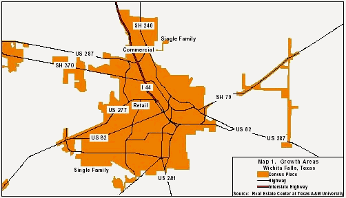
Figure 47(18)
Southwest Wichita Falls has seen the majority of new commercial and residential growth (see Figure 47). Single-family homes are also being built at Sheppard AFB. According to city planning officials, most of the 2000 residential platting activity was located in the south. There is also residential activity along Barnett Road in the Southwest corridor. South of Southwest Parkway are developments such as Stone Lake, Bridge Creek, Hill & Hill and Rolling Hills. The second major growth area is along Seymour Highway, where the 128-lot Canyon Trails subdivision is located. Scattered development is occurring outside the city limits to the northeast and west. The newest growth corridor is in northern Wichita Falls, around Sheppard AFB. This area is experiencing increases in office and retail development, including a Wal-Mart Supercenter on Lawrence Road and two proposed strip malls at the corner of Airport Drive and I-44. The majority of the commercial growth for Wichita Falls has been along 1-44, Highway 287 and Kell West in the Southwest and Northwest corridors. (18) Population projections for the Wichita Falls MSA are shown in Table 59.
Wichita Falls MSA Population Projections

Table 59(4,6)
Abilene MSA
The Abilene MSA consists of Taylor County. In Table 60 , population growth is shown from 1990-2000.
Abilene MSA County Population
![]()
Table 60 (3)
The population of the Abilene MSA has increased at an average annual rate of 0.5 percent over the past ten years. Population projections from the Texas State Data Center forecast a growth rate of 0.7 percent per year through 2010. Abilene’s distance from other major cities is one reason its growth rate is slower than the rate for the state as a whole.(18)
Abilene Market Overview 2001 Urban Growth Patterns
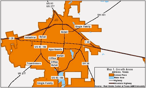
Figure 48(18)
Most Abilene area growth has occurred along Business 83. Industrial growth is occurring on the west side along I-20 in the Greater Abilene Industrial District. Retail activity has focused along U.S. 84. Some residential growth has occurred to the northeast along Highway 351 and to the south off FM 89. Office space has developed along Business 83. Figure 48 shows growth areas. Growth to the east is limited by the Abilene Regional Airport and the Elmdale Airport and to the southwest by Dyess AFB. (18) Population projections for the Abilene MSA are shown in Table 61.
Abilene MSA Population Projections

Table 61(4,6)
San Angelo MSA
The San Angelo MSA consists of Tom Green County. Table 62 shows the population in 2000 and the growth rate from 1990-2000.
San Angelo MSA County Population
![]()
Table 62(3)
San Angelo Market Overview 2001
Urban Growth Patterns
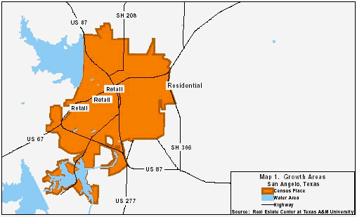
Figure 49(18)
Figure 49 indicates San Angelo’s growth areas. Strong retail growth is occurring along Sherwood Way, which runs northeast to southwest through the city. Residential growth is expanding in east San Angelo. Downtown is expanding and adding a new museum.(18) Population projections for the San Angelo MSA are shown in Table 63.
San Angelo MSA Population Projections

Table 63(4.6)