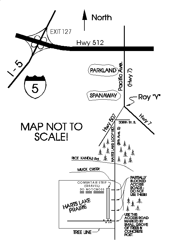
From Interstate 5:
From
Tacoma, take I-5 south to Hwy 512. From Olympia, take I-5 north to Hwy
512. Take Hwy 512 (exit 127) east to Hwy 7. Take Hwy 7 (Pacific Ave.)
south through Parkland and Spanaway to the Roy "Y". Take Hwy 507 (Roy
exit) - watch for poorly marked Harts Lake Loop Rd (8th Ave. S.) exit
where 208th St. and Harts Lake Loop Rd. connect to Hwy 507. Take Harts
Lake Loop Rd. south past RR tracks, through woods, and past Muck Creek. DO
NOT use partially blocked access roads - they cross a gravel Combat Air
Strip used by the U.S. Army! DO NOT CROSS THE GRAVEL COMBAT AIRSTRIP! Use
access road on right by small grove of trees, concrete post, and hopefully
a model club's temporary sign directing you to flying site. Keep watch
across prairie for cars parked in middle of field. There are no
"facilities" (sani-cans) at the field - plan accordingly. WARNING! This is
a military exercise area - there may be hazardous items laying
about.
|
|