Ensenada to San Quintin and Rosario
|
Andar tras mesoamérica : Tijuana GringoCountryside & Metropolis : Baja California |
Diary |
Poemas |
Archeology |
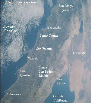
Ensenada to San Quintin and Rosario
Santo Tomas. San Vicente. Sierra San Pedro Martir. Santo Domingo. San Quintin. El Rosario.
.........Travel south into Baja California beyond Ensenada and la Bufadora (for foreigners including United States citizens) requires possession of a tourist visa, available from Mexican consulates in the U.S. or from Mexican customs (aduana) right at the border gate. There is a fee of about twenty-two dollars, and a valid passport or authentic (with raised seal) birth certificate must be presented. Normally these "tourist cards" are good for 180 days; and aside from showing respect for the laws of this country, they are an excellent form of identification and will help you immensely if the police ever stop you. Tourists are a valued resource in Mexico, and such identification is an investment well worth the time and small amount of money.
.........
NOTE: 1 kilometer = 2/3 mile.
The mountainous coast south of Ensenada is a truly spectacular drive best attempted during daytime hours -- both for your safety and enjoyment of the scenery -- one of the best reasons to visit Baja California, anyway.
Santo Tomas
Dropping into this beautiful valley you will soon come to the river bridge, and then a road branching to the right, leading to the beach downriver at the mouth of the twisting canyon (30 kilometers). Our friends tell us that this stretch of coast is spectacular -- like Big Sur. Upwelling cold currents under the sea support a huge panoply of marine life along this coast, and moderate the climate near the sea. http://manejo.ens.uabc.mx/Pagina-Matorral/matorral/ecologico/ecologia-erendira.html.
Continuing along the transpeninsular highway, the "town" -- such as it is -- soon appears. A campground and picnic area sits near the old store, gas station, restaurant and hotel of El Palomar.
Other roads, near El Palomar, and further on towards San Vicente, as well as in San Vicente Valley, turn toward other attractive beaches, notably San Isidro and Ejido Erendira. Consult a map, or several of them, carry supplies, and keep an eye on the weather. Camping and rustic motels are reportedly scattered here and there. You might also search and check with other Baja California websites other than the ones I link from this page.
San Vicente
The valley of San Vicente is an important agricultural area with gas, restaurants, motel, community museum on the plaza, and mission ruins some distance west of the highway, a kilometer north of town. It is also a starting and ending point for several main (but still dirt) roads leading to the beaches of this part of Baja California.
Entering the coastal plain
After San Vicente, the transpeninsular higway twists and turns through more mountain scenery before dropping down to the coastal plain at Colonet. Fog os sometimes a problem on the grade coming down. Several very bad auto/truck/bus collisions have occured exactly here because of speeding in the mist. Plus being night.
Safely reaching the lower elevations, you enter a vast agricultural zone with access to beaches and the mountains. For the next 100 kilometers the highway parallels the ocean, with the huge Sierra San Pedro Martir looming in the east.
Parque Nacional Sierra San Pedro Martir
The main road (about the only road, and graded dirt, too) into the mountains branches east about 14 kilometers south of Colonet, or 15 kilometers north of Camalu. The national park -- with its largely unexploited opportunities for camping and backpacking -- is some 80 kilometers east and 3,000 meters (9,000 feet) above sea level -- truly an island floating in the sky. On the way you pass near the old Meling Ranch with its comfortable accomodations, good meals, horseback riding, even packhorse trips into the mountains. Go ahead, bwana, splurge.
On top of "la encantada" -- the enchanted place -- as San Pedro Martir is also known -- Mexico's national observatory is said to be open to visitors only on Saturdays between 11 a.m. and 1 p.m. (per Lonely Planet).
In winter, the mountains are often covered by dense snow, making access difficult, but meanwhile down in the foothills (at the Meling Ranch) you can snuggle before a crackling fireplace. I hope they give us a discount for all this publicity. Oh what the hell, they're famous already. We'll go back there no matter what.
Recommended times to visit are spring, summer and fall. Forests, meadows, and spectacular views of the desert abound in the highest elevations. Take plenty of supplies and maps, maybe even hire a qualified guide.
Mike's Sky Rancho is an alternative resort in the foothills, especially for off-roading types. Be careful driving those roads.
Santo Domingo -- Vicente Guerrero
The ruins of this important Dominican mission are eight kilometers east of the highway via a dirt road on the north side of the river bridge north of the town of Vicente Guerrero. The first week of every August the Fiesta de Santo Domingo enlivens the historic ruins with rodeas, music, food, etc. A nearby private park provides year-round recreational opportunity with swimming and picnic grounds for a small admission fee.
An agricultural town stretching alonside the highway, Vicente Guerrero has a couple motels and campgrounds. Dirt roads lead toward the long beaches. There are miles and miles of beaches hereabouts.
San Quintin
At the center of this long coastal terrace, the aglomerations of San Quintin and Lazaro Cardenas straggle alongside the highway, offering all services required, motels (but better you should stay by the bay or beach!), restaurants, beer depositos (stores), groceries (mandado) and bus stations, to name a few.

San Quintin Bay is a curious place, with its extinct volcanoes clustered around the twisted arms of water. It lies only a couple kilometers west of the highway. The best road to the western bay, farther shore, and ocean beaches turns off the transpeninsular beside the military camp corner, cuts across the dusty fields, then over a swampy backwater, and eventually turns left toward the volcanoes, dividing into branches going here and there. Other roads farther south lead to the eastern (nearer) bayshore with its few classic motels, crumbling ruins, and old English cemetery.
This area was the center of a failed colonization attempt in the late 1800s. Remains of a of a cannery, as well as a dyke built across the neck of the bay for a railroad bridge, can be seen by the Old Mill Motel.
The area is also the site of the mythical city of San Miguel, featured in our writer Phillip Relmond's novel The Onyx City, based loosely on the aforementioned colonization scheme. Fiction is stranger, and stronger, than truth, sometimes. While hitchhiking back from Mulege, Michael had one driver believing Phillip's story was true, even though he said it wasn't. Watch out.
South of the river that burst its dam and destroyed the Onyx City after Delano set it to the torch, another road turns west toward the ocean shore hotel and motel that sit about a kilometer apart but much farther in philosophy of accomodation. Pinta and Santa Maria. Seriously. There be dunes here.
Further development is threatened for this rustic spot, and there are labor troubles between the big growers and their immigrant workers (mostly from Oaxaca) who must pick the salads of North America and get paid practically nothing. But meanwhile there are still opportunities for endless beachcombing, fishing, and seashore camping for all you dear bourgeois and working friends on vacation. Watch out for snakes, as well as scorpions, rip tides and mud.
El Rosario
For 50 some kilometers shouth of San Quintin the highway hugs the coast, sometimes separated from the sea by a wall of sand dunes. Then it turns inland and arrives at El Rosario. Here is where the great mountains and upwelling sea breathe their last northern influence and the climate transforms from temperate into desert. This is the last outpost of the so-called "San Diegan" bioclime, which covers all of southern California and northern Baja California state. From here on in, the traveler will be entering the vast central desert of the peninsula, with all its weird plants and spectacular, dry scenery.
Towns & People | Culture & Nature | Countryside & Metropolis | Ancient, Modern & Colonial Places | Valley and Mountain |
Andar tras mesoamérica : |
Diary |
Poemas |
Archeology |

|
|

|
| Tijuana Gringo |