Scientific programs
img src="Seal.gif" border=0 height=55 width=111>
The Antarctic Pack-Ice Seals Project (APIS)
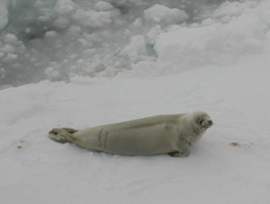
Pack-ice seals are among the dominant top predators of the
Southern Ocean ecosystems. The Crabeater seal is the most abundant of
the pack-ice seals, and is now the largest single consumer of
krill.
 Better knowledge
of the distribution and abundance of pack-ice seals, particularly the Crabeater,
is essential for understanding the significant predator-prey interactions in
the Southern Ocean. Such information is required to examine the effects of management
strategies for krill fishing.
Better knowledge
of the distribution and abundance of pack-ice seals, particularly the Crabeater,
is essential for understanding the significant predator-prey interactions in
the Southern Ocean. Such information is required to examine the effects of management
strategies for krill fishing.
The survey program is the major Australian contribution to the
Antarctic Pack-Ice Seals program (APIS) developed by the Scientific
Committee on Antarctic Research Group of Specialists on Seals. The
study will contribute to understanding the relationship between the
marine life and both the physical oceanography and the role of the
sea-ice.
As a key species, estimates of the number of Crabeater seals are
required to quantify their role in the Southern Ocean ecosystem. The
Crabeater seal preys predominantly on krill, and is therefore a key
species in terms of possible impacts of krill fishing on the Southern
Ocean ecosystems.
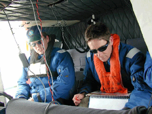 Estimation of the
distribution and abundance of pack-ice seals in the waters off the Australian
Antarctic Territory will be achieved by scientists surveying from helicopters
and from the bridge of the ship.
Estimation of the
distribution and abundance of pack-ice seals in the waters off the Australian
Antarctic Territory will be achieved by scientists surveying from helicopters
and from the bridge of the ship.
The whole life cycle of Crabeater seals unfolds within the sea-ice. They spend
time foraging in the water, mostly in the evening and time on sea-ice resting
and breeding. Capturing several under sedation and attaching satellite linked
dive recorders will provide more information on their behaviour and enable corrections
to be made to the survey results.
By recording data on the sea-ice and factors affecting marine life, the scientists
hope to gain a better understanding of their relevance in determining the distribution
of pack-ice seals.
Below is a map of Antarctica showing surveyed areas. Red indicates ship based
survey. Blue indicates aerial based survey.

click on "Tim the
Penguin" to return to Antarctica 1999-2000 Page

Ā