 Washington 509
Washington 509
Washington 509
| Termini | WA-99 at E Marginal Way at the 1st Ave bridge in Seattle to WA-7 at S 38th St in Tacoma |
| Length | 36.0 miles southbound; 36.3 northbound |
| "Where does it go?" | WA-509 is as close Washington gets to a "signature" state highway (example CA-1, FL-A1A), at least in the west. It runs along the eastern shore of Puget Sound from South Seattle to Tacoma, via Burien, Des Moines and Federal Way. |
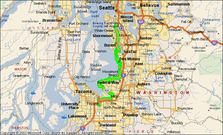
| SB Miles | Southbound down | Northbound up | NB Miles | Multiplex | Near City or Town |
County |
| 0.0 |  E Marginal Way |
36.3 | |
Seattle | King | |
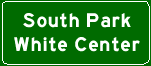
| 0.9 | 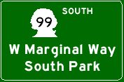 |
|
35.4 | |||
| 1.3 |  |
 |
34.7 | |||
| 3.0 | 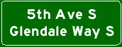 |
|||||
| 4.0 | 31.9 | |||||
| 5.2 | 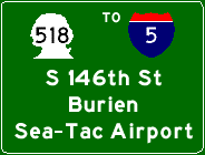 |
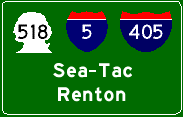 |
30.6 | Burien | ||
| 6.1 | 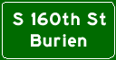 |
29.8 | ||||
| 7.5 | Des Moines Memorial Dr |
 Des Moines Memorial Dr |
28.3 | Des Moines Memorial Dr | ||
| 8.2 | S Normandy Rd | 27.8 | Ambaum Blvd S | |||
| 8.5 | Ambaum Blvd S | 27.6 | S 174th St | |||
| 8.6 | S 174th St | 27.4 | 1st Ave S | |||
| 9.0 | SW Normandy Rd | 27.0 | ||||
| 10.3 | S 199th St | 25.8 | ||||
| 10.3 | S 200th St | 25.8 | ||||
| 11.7 | Des Moines Memorial Dr | 24.4 | Marine View Dr S | Des Moines | ||
| 11.8 | 7th Pl S | 24.3 | ||||
| 12.5 | Marine
View Dr S Kent Des Moines Rd |
23.6 |  Kent Des Moines Rd |
|||
| 13.2 |  Kent Des Moines Rd 16th Ave S |
22.9 | 16th Ave S | |||
| 14.8 | S
260th St Woodmont Dr S |
21.2 | ||||
| 15.6 | S 272nd St | 20.5 | ||||
| 16.0 | Pacific Hwy S |
20.0 | Pacific Hwy S |
Federal Way | ||
| 16.6 | S 288th St | 19.5 | ||||
| 17.1 | Pacific Hwy S |
18.9 | S Dash Point Rd | |||
| 18.5 | 1st Ave S | 17.6 | SW Dash Point Rd | |||
| 18.6 | SW 301st St | 17.4 | ||||
| 19.9 | SW 312th St | 16.2 | ||||
| 20.1 | 21st Ave SW | 15.9 | ||||
| 22.3 | 47th Ave SW | 13.7 | ||||
| 23.2 | Dash Point State Park | 12.9 | ||||
| 25.6 | Slayden Rd NE | 10.5 | East Side
Dr NE Marine View Dr |
Tacoma | Pierce | |
| 28.2 | E 11th St | 7.9 | Marine View Dr | |||
| 28.4 | McMurray Rd NE | 7.7 | ||||
| 28.9 | Norpoint Way NE | 7.2 | ||||
| 30.7 | Taylor Way E | 5.3 | Marine
View Dr Frontage Rd |
|||
| 32.7 | 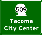 |
|
3.4 | |||
| 2.3 | ||||||
| 34.6 |  |
1.5 | ||||
| 34.6 |  |
 |
1.4 | |||
| 34.7 | Pacific
Ave S 21st St |
1.4 | S 21st St Pacific Ave |
|||
| 35.0 | S 25th St | 1.1 | Pacific Ave | |||
| 35.0 | S
Tacoma Way S 26th St |
1.0 | ||||
| 35.1 | S 27th St | 1.0 | ||||
| 35.2 |  |
|||||
| 36.0 |  S 38th St Pacific Ave |
0.0 | ||||