Pilot Mountain State Park
North Carolina
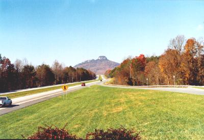 Approaching from the South
Pilot Mountain rises 1400' feet all by itself out of the piedmont
north of Winston-Salem. Obviously it's a very prominent landmark and was
used as a "pilot" by Indians and early European settlers. The Indians called
it Jomeokee, the pilot. By the way, do you realize that the Empire
State Building, in New York City, is almost as tall? Just imagine it standing
on the piedmont, too. It would come up to the cliffs on the pinnacle.
 Road to the Summit
You can drive to the Summit Parking Area, near the top. From there, you
can walk to the top of the Little Pinnacle, where you can view the
Big Pinnacle up close. The Big Pinnacle, however, is surrounded by 200'
high cliffs, so you can walk to it's base, but not to its top. The Jomeokee
Trail goes around the base of the cliff. I wonder if there's any perhistoric
life up there in the forst on the top of the isolated pinnacle?
Road to the Summit
You can drive to the Summit Parking Area, near the top. From there, you
can walk to the top of the Little Pinnacle, where you can view the
Big Pinnacle up close. The Big Pinnacle, however, is surrounded by 200'
high cliffs, so you can walk to it's base, but not to its top. The Jomeokee
Trail goes around the base of the cliff. I wonder if there's any perhistoric
life up there in the forst on the top of the isolated pinnacle?
 Guide to the Summit Area
 Summit Parking Area
 Summit Area
 The View from the Top
The town of Pilot Mountain is barely visible in the photo. Those are clouds
on the horizon. The Blue Ridge is about 25 miles away to the left and is
barely visible (but not in this photo). Another nearby town is King, North
Carolina, which to the right of the photo. The highway (north is towards
the left) goes on up to Mt. Airy. The whole area is the setting for the
ficticious town of Mayberry, North Carolina, from the Andy Griffith
Show. Mt. Pilot was the ficticious big city they always spoke of in
Mayberry.
The View from the Top
The town of Pilot Mountain is barely visible in the photo. Those are clouds
on the horizon. The Blue Ridge is about 25 miles away to the left and is
barely visible (but not in this photo). Another nearby town is King, North
Carolina, which to the right of the photo. The highway (north is towards
the left) goes on up to Mt. Airy. The whole area is the setting for the
ficticious town of Mayberry, North Carolina, from the Andy Griffith
Show. Mt. Pilot was the ficticious big city they always spoke of in
Mayberry.
 Hiking Around the Summit
 At the Base of the Big Pinnacle
 Our Campsite
Just as I've come to expect from state parks, in contrast to the Blue Ridge
Parkway, the campground was very nice and the rangers were very friendly.
Unfortunately the road to the summit closes after dark. The summit would
be a great place to look at stars.
Our Campsite
Just as I've come to expect from state parks, in contrast to the Blue Ridge
Parkway, the campground was very nice and the rangers were very friendly.
Unfortunately the road to the summit closes after dark. The summit would
be a great place to look at stars.
Camping Page / Family
Homepage / Dec. 4, 1998