

The City of El Minia looking East from the Hills across the Nile
The City of El Minia looking East from the Hills across the Nile
Egypt is divided administratively into Governorates, a system already in
use in Pharaonic times.
Minia Governorate
lies somewhere about half way South along the Nile Valley.
It is about 135km long
by 17.5km wide and
represents about 7% of the inhabitable Valley area. The Governorate's
population is estimated at about 2.5 m, while that of El Minia City is
roughly over 500,000. Christians in Minia are estimated at
about 15% of the population, i.e. well above the average for the whole
country. (Please Note: all figures are rough extimates
and by no means official)
| Many place names in Egypt, even today, are of ancient Pharaonic origin, and Minia is one such example. The are some relatively important Archeological sites, the best known being Tell El Amarna, Touna el Gebel and Beni Hassan, but there are others. It was here that Pharaoh Akhenaton decided to build his new capital, From Thebes in Luxor to Tell El Amarna, about 40km sout of El Minia City. Of course there are also a number of Christian and Islamic sites of historical interest. | 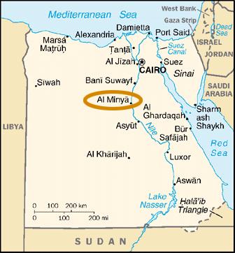 |
 |
The City of El Minia, the Capital of Minia Governorate, lies about 240km south of Cairo. Its symbol is Queen Nefertiti, Pharaoh Akhenaton's wife. El Minia is nicknamed the "Bride of Upper Egypt" and is quite a pleasant town outwardly. Unfortunately, it is less so economically, having probably the highest rate of unemployment rate in Upper (i.e. Southern) Egypt. |
| Queen Nefertiti |
You can find our more about my work in the following Pages:


You can find out more about the Jesuits' presence in Minia in the following pages:


You may be interested to look up the following pages and links:


 |
|