DESCRIPTIVE SKETCH
OF VICTORIA
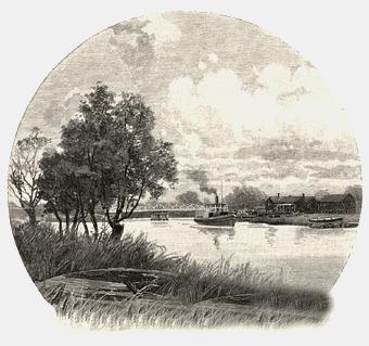
Atlas Page 37
By James Smith
VICTORIA - RIVERS.
As in New South Wales, so in Victoria, there are two watersheds
—the one flowing from the Southern and the other from the northern slopes of the
Great Dividing Range; the streams which take their rise in the latter emptying themselves
into the Murray —except in the case of some that disappear in the porous soil of the
north-western districts of scrub and sand —while those springing from the opposite
side of the ridge find their way direct to the sea. In many instances the little rills
which afterwards grow important rivers, and obtain an outfall at points two hundred miles
asunder, begin to ooze out of the mountain tops within a few hundred yards of each other.
The Murray, from Forest Hill, near the source of one of its tributaries, to the one
hundred and forty-first meridian of east longitude, forms the boundary line of the two
colonies, and receives in its progress the waters of the Mitta Mitta, the Kiewa, the
Ovens, the Goulburn and the Loddon, as well as those of about a dozen creeks, each of
which helps to swell its volume at certain seasons of the year.
 The more important of the streams which flow southward are the
Genoa, the Snowy, the Buchan, the Brodribb, the Nicholson, the Tambo, the Mitchell, the
Avon, the Macallister, the Thomson, the Latrobe, the Yarra, the Werribee, the Moorabool,
the Barwon, the Gellibrand, the Hopkins, the Eumeralla, the Wannon and the Glenelg. That
part of the colony which lies eastward of the one hundred and forty-fifth parallel, and
southward of the railway line from Seymour to the Murray, may be said to abound in
watercourses. In this region the mountains reach their greatest altitude; in this region
also occurs the heaviest rainfall, amounting to fifty inches per annum in some places, and
ranging from thirty to fifty over a large area of heavily-timbered ranges; and in this
region a single river —like the Yarra, for example —will receive the
contributions of a hundred affluents before emerging from the highlands in which it has
its birth.
The more important of the streams which flow southward are the
Genoa, the Snowy, the Buchan, the Brodribb, the Nicholson, the Tambo, the Mitchell, the
Avon, the Macallister, the Thomson, the Latrobe, the Yarra, the Werribee, the Moorabool,
the Barwon, the Gellibrand, the Hopkins, the Eumeralla, the Wannon and the Glenelg. That
part of the colony which lies eastward of the one hundred and forty-fifth parallel, and
southward of the railway line from Seymour to the Murray, may be said to abound in
watercourses. In this region the mountains reach their greatest altitude; in this region
also occurs the heaviest rainfall, amounting to fifty inches per annum in some places, and
ranging from thirty to fifty over a large area of heavily-timbered ranges; and in this
region a single river —like the Yarra, for example —will receive the
contributions of a hundred affluents before emerging from the highlands in which it has
its birth.
The Murray drains an area, in this colony alone, of upwards of forty
thousand square miles, and is navigable by steamers from Wodonga to its outlet in Lake
Alexandrina, though the depth of water in it fluctuates materially from time to time and
from year to year. In the early summer, when the snow begins to melt on Mount Kosciusko
and the neighbouring ranges, the river will sometimes rise bank high; and during the rainy
season, when its waters are swollen by those of the Murrumbidgee, the Billabong, the
Lachlan and the Darling, they overflow the low-lying country in various places, filling up
back-water creeks and forming extensive lagoons. Steamers freighted with wool and other
pastoral produce lend a character of unwonted animation to the great waterway at such a
time, and squatters occupying stations in the far interior of New South Wales, hundreds of
miles distant from the river’s junction with its main affluents, gladly avail
themselves of the facilities afforded by the stream for the conveyance of their products
to port —facilities which are apt to be interrupted by long and trying intervals,
during the too frequent periods of protracted drought.
In the south-east of Victoria, the rivers which head from the northern
slope bear a strong general resemblance to each other. They take their rise in the
mysterious recesses of mountains so thickly clothed with timber and so inaccessible that
the sanctuaries of Nature have remained for centuries unprofaned by human foot, but it
almost impossible to indicate with any degree of accuracy the precise fountain-head of
either of these rivers. A score of, little rills, issuing from moist crevices high up
among the hills, will trickle down their furrowed sides and mingle their waters in a
runnel that glides beneath a grove of tree-ferns in a narrow gorge impenetrable to the
sunlight. The stream will receive continual accessions in its course, and each will
increase its velocity until at the higher end of a ravine, the precipitous walls of which
approach so nearly that the trees which have found a precarious foothold in their clefts
mingle their foliage overhead, the stream springs over a ledge of porphyritic or basaltic
rock and is partly dissipated in foam before it reaches its sombre channel, one, two, or
three hundred feet below. And then, as if it had gained impetuosity, by its descent, it
swirls around the boulders which impede its onrush to the distant plains, surging against
the trunks of the trees that have fallen across its path, undermining the roots of others,
and breathing a sense of refreshing coolness into the atmosphere which envelops the
motionless verdure that tapestries its banks. Sometimes —as in the case of the Genoa
and Snowy Rivers, the Tambo and the Mitchell —these mountain-born streams are flanked
by sinuous ranges from their hidden birthplaces until they come within a few miles of the
sea ; so that, for forty, leagues or more, they disclose a succession of romantic
landscapes, having a certain correspondence in their broader features and more salient
characteristics, but presenting an endless variety of detail.
 The principal source of one of the rivers just named —the
Tambo —is near Mount Leinster, on the southern slope of the Bowen Mountains, and on
the opposite side rises the Limestone Creek, which some explorers suppose to be the real
commencement of the River Murray, flowing northward for something like a hundred miles
through country, not less romantic than that which has been described above. When the
Tambo, the Nicholson, the Mitchell and the Avon emerge from the fastnesses amidst which
they have pursued their devious course in a southerly direction,
The principal source of one of the rivers just named —the
Tambo —is near Mount Leinster, on the southern slope of the Bowen Mountains, and on
the opposite side rises the Limestone Creek, which some explorers suppose to be the real
commencement of the River Murray, flowing northward for something like a hundred miles
through country, not less romantic than that which has been described above. When the
Tambo, the Nicholson, the Mitchell and the Avon emerge from the fastnesses amidst which
they have pursued their devious course in a southerly direction,
Round valleys like nests all ferny-lined,
Round hills with fluttering tree-tops feathered,
their progress becomes more sedate and measured, as if they had
exchanged the impetuosity of youth for the seriousness of maturity. They no longer hasten
seaward, but expatiate leisurely with "many a winding bout," through alluvial
plains of great fertility. These rich bottom lands resemble, indeed, a bank of deposit in
which nature has been storing up, for a long succession of centuries, a fund of wealth for
many generations of agriculturists to draw upon; and here, if anywhere, the words of
Jerrold are true: "If you tickle the ground with a hoe, it will laugh with a
harvest." The orchards and gardens of the district resemble in their fruitfulness
those of the English county of Kent; and as the tourist journeys down the Gippsland lakes
in a steamboat, he finds at the principal stopping-places men, women and children offering
for sale the fruit then in season, as large in size and as luscious in quality as he is
accustomed to see taking the chief prizes at the horticultural shows in Melbourne and
elsewhere. Of the hop gardens which formerly beautified the banks of the Tambo and the
Mitchell in their lower reaches, comparatively few remain, as the cultivation of that
plant has been abandoned in favour of more remunerative products; and this must be a
source of regret to every lover of the picturesque, for, where they still exist, they lend
a charm to the scenery, which no other objects can supply. When the flower is perfected,
and the vines are full of leaf, the effect of these long, narrow aisles, with a cluster of
slender pillars on every "hill," and each pillar wreathed with the most complex
and delicate foliage, so graceful in curve and so endless in diversity of line, with
tendrils reaching across the avenues to form a fretted vault, is simply matchless; and the
scene at hopping time —when the uprooted poles are laid upon the crossbars of the
"bins," and the nimble fingers of women are busily occupied in shredding the
golden flowers, and children busy themselves in the heaped up bines, and the air is filled
with the subtle aroma of the hop —is more picturesque than any vintage, except,
perhaps, in Tuscany. And even when
The tented winter field is broken up
Into that phalanx of the summer spears
That soon shall wear the garland,
the spire-like piles of packed poles are interesting features in the
landscape, because they are eloquent of the bounteous crop that has been gathered in, and
suggest the verdure and beauty of the coming spring.
The Avon, which takes its rise in the county of Tanjil, flows in a
south-westerly direction through the fertile plains of Gippsland until it enters Lake
Wellington at the same northerly point at which the smaller stream called the Perry joins
it. The Thomson flows along the foot of a lateral chain of hills springing from Mount
Lookout. Where this ends, it unites its waters with those of another stream —the
Aberfeldy —which has pursued a parallel course on the opposite or eastern side of the
same range, and having been reinforced by the Macallister —a tributary that has
drained a considerable tract of mountainous country to the north —the Thomson empties
itself into the Latrobe, about three miles to the south of Sale. The Latrobe rises among
the southern slopes of the great spur, which branches off abruptly, near Mount Matlock,
running down in a south-easterly direction, and almost in a straight line, as far as Mount
Baw Baw: it then doubles back again so as to form two sides of an acute triangle, within
which is enclosed some of the most beautiful scenery in Victoria, and afterwards pursues a
sinuous course until it terminates in the huge masses of the Dandenongs.

At the apex of this triangle, on its inner side, there is an elevated
plateau; and almost under the shadow of Mount Baw Baw the waters of the Yarra take their
rise. At that elevation, magnificent forests of beech trees appear to have supplanted the
eucalyptus, to a very great extent at least, and add greatly to the charm of the
landscape. At the birthplace of the river, upon which the natives bestowed the title of
the Everflowing, numbers of little streams of pure cold water, which
—sparkle out among the fern
To bicker down a valley,
combine to form a rivulet not more than twenty feet wide. Through a
shallow valley, shadowy, with stately beeches and tall tree-ferns, the brook goes singing
on its way until, all of a sudden, it finds an outlet into a valley at a much lower level,
and with a succession of leaps, by which it forms a series of fine cascades as pleasant to
the eye as to the ear, it effects a descent of something like a thousand feet. After this,
its course lies along the bottom of a deep ravine, the precipitous sides of which, varying
in height from one to two thousand feet, are heavily timbered, the trees springing from a
matted undergrowth of scrub. About fifteen miles below the falls, the river reaches a
small mining township which has received the name of Reefton. This is the highest point of
the stream at which there are any inhabitants, or wherewith there is regular
communication. For the next thirty miles of its serpentine course, the scenery upon its
banks is extremely picturesque. It hurries along over boulders, and shingle and
"bubbles into eddying bays, and babbles on the pebbles," receiving numerous
tributaries which come tumbling down the steep slopes, completely hidden from view by the
over-arching fronds of the fern-trees, but betraying their presence by the wonderful
vividness and rank luxuriance of the masking vegetation. The stream, although generally
from sixty, to a hundred feet wide, is rarely more than three or four feet deep. On its
northern bank, the ranges rise to a height of between two and three thousand feet just
below the point at which it effects a junction with Badger Creek, the Yarra emerges into a
level, open country, and soon afterwards receives the waters of the Watts. These come down
through a deep, narrow valley lying between Mount Juliet and the Dividing Range; but the
sources of this pure perennial stream have been only partially explored, owing to the
steep and rugged character of the mountains in this region, and the extraordinary density,
of the undergrowth in the forests by which they are covered. The forests themselves are
remarkable as the habitat, among others, of the Eucalyptus amygdalina, originally figured
and described by Labillardiere. It reaches a greater altitude than any other known tree
upon the face of the globe. Baron von Mueller, the Government botanist for the colony of
Victoria, whose "Eucalyptographia" promises to become a standard authority on
the subject, states that he himself has obtained approximate heights of four hundred feet
for this tree at the Black Spur, a few miles beyond Fernshaw, in these ranges; that
measurements up to one hundred and ten feet were procured by Mr. A. W. Howitt in
Gippsland; and that Mr. R. Boyle ascertained the length of a tree of this kind which had
fallen in the Dandenong Ranges to be four hundred and twenty feet, or within thirty feet
of the height of the Great Pyramid. Another measurement showed that the length of the stem
up to the ramification of the first branch, where it had a diameter of four feet, was not
less than two hundred and ninety-five feet. Some of these giants of the forests have
circumference of one hundred and thirty feet close to the ground; and upon a square mile
of land as many as a hundred trees have been counted, none of which have been less than
forty feet in circumference at their base. This variety is remarkably rapid in its growth,
and has been known to reach a height of sixty feet in nine years, besides being one of the
hardiest members of its species. Its foliage is exceptionally rich in oils of great value,
both medicinally and economically, as not less than five hundred ounces have been
distilled from one thousand pounds of the fresh leaves of the Eucalyptus amygdalina with
their stalklets and branchlets. These forests are also the home of the Eucalyptus
globulus, the most precious gift, perhaps, which the flora of Australia has presented to
the Old World. The seeds of this tree, the leaves of which are literally for "the
healing of the nations," were first sent to Italy, for plantation in the Pontine
Marshes, by Dr. Goold, the late Archbishop of Melbourne, in 1869, and thus was commenced a
movement which seems destined to combat and conquer malaria in all its European haunts.
The minor streams which flow into the sea or its inlets in the
south-western portion of Gippsland —such as the Albert, the Tarra, the Agnes, the
Morwell, the Powlett, the Bass, the Tarwin, the Franklin, the Tarago, the Buneep, and the
Moe drain the lower part of the county of Buln Buln, as also that of Mornington; the Lang
Lang and the Tarago creeping sluggishly through a wide-spreading marsh of not less than
seventy thousand acres in extent, and bearing the native name of the Kooweerup Swamp.
 To the westward of the Yarra, the Plenty takes its
rise in the ranges which were first crossed by Hume and Hovell in the year 1824, and
received the name of the former, but they are now generally known as the Plenty Ranges.
They form an integral portion, however, of the Great Divide, and the stream just spoken of
flows into a reservoir constructed by throwing an embankment across the valley, and serves
as one of the main sources of water supply to the city of Melbourne and its belt of
populous suburbs. About forty miles distant, in a straight line to the westward, the
Saltwater River heads back to the Cordillera, and receiving many creeks in its serpentine
course, accomplishes a journey of a hundred miles before it discharges itself into the
Yarra, a few miles above the head of Hobson’s Bay.
To the westward of the Yarra, the Plenty takes its
rise in the ranges which were first crossed by Hume and Hovell in the year 1824, and
received the name of the former, but they are now generally known as the Plenty Ranges.
They form an integral portion, however, of the Great Divide, and the stream just spoken of
flows into a reservoir constructed by throwing an embankment across the valley, and serves
as one of the main sources of water supply to the city of Melbourne and its belt of
populous suburbs. About forty miles distant, in a straight line to the westward, the
Saltwater River heads back to the Cordillera, and receiving many creeks in its serpentine
course, accomplishes a journey of a hundred miles before it discharges itself into the
Yarra, a few miles above the head of Hobson’s Bay.
A little to the northward of Mount Wilson, which forms part of a spur
thrown off by the Great Dividing Range, Werribee takes its rise, and flows through a
highly picturesque country, like its principal affluent, the Lerderberg, until it reaches
Bacchus Marsh; below this it begins to groove a deep channel through a wide spreading
champaign, across which its tortuous course is clearly defined by an irregular avenue of
trees, eventually finding an outlet in Port Phillip Bay not many miles to the eastward of
the outfall of the Little River, the unimportance of which is sufficiently denoted by its
expressive name.
The right branch of the Moorabool has its origin close to the sources of
the Werribee; while the left, locally known as the Lal Lal Creek, heads to the Great
Dividing Range, a few miles to the north-east of Ballarat. The two streams effect a
junction five miles to the eastward of a township bearing the poetical name of Elaine; and
the river, pursuing a southerly direction, skirting the Steiglitz Ranges, flows through
some romantic scenery, with high cliffs rising like a gigantic wall upon one side of the
stream, until it merges its separate existence in that of the Barwon, which absorbs also
the waters of the Yarrowee. The latter comes down from the north, and has its birth in the
auriferous region of which Ballarat is the centre, whence it takes a north-easterly
direction as far as Inverleigh, the point of junction with the Yarrowee; shortly
afterwards it curves round to the south-east, and ultimately discharges its waters into
Lake Connewarre, having an outlet to the ocean through the Barwon Heads.
 The Erskine, the Barrum, the Parker, the Calder, the Aire, and
the Gellibrand all have their sources in the Coast Ranges, and empty themselves into the
ocean —the first at Loutit Bay and the last at Point Ronald. Rising, as a general
rule, at a great altitude, their downward course lies through gorges heavily timbered with
peppermint, box, messmate, ironbark, blue gum, beech and blackwood —some of them two
hundred feet high except in positions which are much exposed to the south-easterly gales,
where stunted scrub and ti-tree take the place of the noble trees that flourish in more
sheltered situations; while tree-ferns ascend to the very summits of the secondary spurs.
Beautiful cascades are of frequent occurrence, those on the Erskine River, which are
easily accessible from Lorne, being the most notable in this respect.
The Erskine, the Barrum, the Parker, the Calder, the Aire, and
the Gellibrand all have their sources in the Coast Ranges, and empty themselves into the
ocean —the first at Loutit Bay and the last at Point Ronald. Rising, as a general
rule, at a great altitude, their downward course lies through gorges heavily timbered with
peppermint, box, messmate, ironbark, blue gum, beech and blackwood —some of them two
hundred feet high except in positions which are much exposed to the south-easterly gales,
where stunted scrub and ti-tree take the place of the noble trees that flourish in more
sheltered situations; while tree-ferns ascend to the very summits of the secondary spurs.
Beautiful cascades are of frequent occurrence, those on the Erskine River, which are
easily accessible from Lorne, being the most notable in this respect.
The Hopkins, which enters the sea about a mile to the eastward of
Warrnambool, takes its rise on the southern slopes of the Pyrenees, in the neighbourhood
of Mount Ararat, and receives, in its southward progress, the waters of a dozen
tributaries, the most important of these being Mount Emu Creek, which heads to the Great
Dividing Range. The Hopkins is a favourite stream with anglers. It flows through a pretty
country, and the scenery upon its banks is agreeably diversified —now presenting high
cliffs, tapestried with shrubs and creepers; now a sylvan landscape and anon undulating
pastures, sprinkled with sleek cattle or fleecy sheep, and then a rising township, with
its cottages clustering round a primitive church; or a country mansion, like that of
Hopkins Hill, framed in a stately zone of trees, and not unworthy to emulate the country
houses which lend such a charm to rural England.
The Eumeralla serves as a natural drainage channel for a considerable
body of water which accumulates in Buckley’s Swamp, about seven miles to the
north-east of Mount Napier. Thence it flows in a south-westerly direction through a thick
forest of eucalpytus and banksia, with high land of trap formation on either side, until
it reaches the township of Macarthur, where it is joined by the Breakfast and Blackfellow
Creeks, and flows southerly from this point through a marsh; country; this is in some
places seven miles wide, and during a very rainy season the marshes become a series of
lagoons dotted with small islands. On approaching within a mile of the sea coast, it bends
abruptly round to the east, and running parallel with the beach for something like seven
miles, it discharges its waters into Lake Yambuk, which also receives those of the Shaw,
an unimportant stream rising near Harton Hills, twenty miles to the northward in a
straight line.
The Wannon flows from the eastern slopes of the northern extremity of
the Serra Range, and pursues a southerly course until it sweeps round the base of Mount
Sturgeon, when it doubles back in a north-westerly direction as far as the township of
Cavendish. There it is again deflected to the southward, and augmented by many
tributaries, it reaches a ridge of rock about a mile from Redruth. Below the ridge there
is a sudden change in the country, and the river, leaping over a ledge, worn smooth by the
slow erosion of the waters during innumerable centuries, plunges in one bright, broad,
translucent sheet into a pool a hundred feet beneath, where it whirls and eddies amidst
the masses of rock which break it up into many foaming torrents, and greatly add to the
picturesqueness of the scene. Four or five miles from Redruth, the Wannon effects a
junction with the Grange Burn, rising a little to the eastward of the county boundaries of
Villiers and Normanby, and thenceforward the course of the combined streams is
north-westerly until the Wannon merges its identity in the Glenelg, the most westerly, and
perhaps the most circuitous, of all Victorian rivers.
This stream meanders for upwards of two hundred and fifty miles before
it reaches its outfall at Nelson. After emerging from the mountainous region, the Glenelg
takes a northerly direction through grassy flats, sprinkled with stunted timber and
banksia heath for about seven miles, and then makes a sudden bend to the south-west for
upwards of twenty miles, when, its course being obstructed by a low range, describes a
semi-circle to Balmoral, at which point it sweeps round to the north-east for a dozen
miles or so, and once more folds back upon itself and pursues a south-westerly path, with
capricious windings, through high banks, clothed for the most part with timber, until it
absorbs the waters of Power’s Creek, flowing into it from the westward. Here it
commences its southward career, but still erratically, and augmented by the Stokes and the
Crawford and the Glenaulin Creek, it flows down to within a few miles of the ocean, starts
off in a westerly direction, and once more curves round to the east before emptying itself
into the sea.

The Wimmera is the most westerly of those Victorian rivers
which belong to its northern water-shed, and may be grouped with the Avon and the Avoca on
account of their common characteristics, for each fails to find its way to the Murray,
which is the reservoir of the whole of the streams to be spoken of hereafter. Taking its
rise in the neighbourhood of Ben Nevis, and augmented in volume by a number of creeks from
the Pyrenees and the Grampians, the Wimmera flows in a north westerly direction until in
the vicinity of Longernong it sends off a branch, locally known as the Yarriambiack Creek,
which eventually disappears in the mallee scrub surrounding Lake Corong. Beyond Horsham
the main stream bends round to the north, flows into and out of Lake Hindmarsh, goes by
the name of Outlet Creek, between this and Lake Albacutya, resumes that appellation in
quitting the latter, and disappears amidst the sand hills which emboss the surface of the
and plain beyond the last named lake. The Avon, which heads to Mount Navarre, and receives
the Richardson —a river that ceases to flow entirely during seasons of protracted
drought —runs into Lake Buloke, four miles north of Donald, and this is subject to
the same infirmity as its tributaries, as it is sometimes dry for years together. The
Avoca, which takes its rise in the amphitheatre formed by the Great Dividing Range in the
neighbourhood of Ben Major, and has one of the most beautiful birthplaces a lover of the
picturesque could desire to see, flows through an equally beautiful country during the
earlier portion of its course. The valleys are bright with verdure, and the hills in some
places are table-topped, in others softly rounded, and carpeted with succulent grasses;
while here and there, among the recesses of the ruggeder of the mountains, are hidden deep
romantic ravines —masses of rock piled up in fantastic confusion —and caves in
which hermits or bushrangers might find all the seclusion they could desire. By-and-by,
however, as the Avoca flows northward, its banks become less and less picturesque until,
at a point almost twenty miles due south of the junction of the Loddon with the Murray,
the stream dwindles down to a mere thread of water, and then disappears.
The Loddon is an aggregation of between twenty and thirty creeks, all of
them taking their rise in the Great Dividing Range or in the northerly spurs which it
throws off, and, after pursuing an erratic course through the county of Talbot, it begins
to flow in a direction almost due north, serving as a boundary line between the counties
of Bendigo and Gambier, on its right bank, and those of Gladstone and Tatchera on its
left. Augmented on its way by the waters of Moonlight Creek and Murrabit River, it flows
into the Murray near Swan Hill. It is likely, hereafter to play an important part in the
artificial irrigation of the surrounding district. This will also be the case with the
Campaspe, which takes its rise in the Dividing Range a little to the westward of Mount
Macedon, and having received the waters of the Coliban at Kimbolton, flows through the
spacious plains which spread out thence to the Murray, into which it discharges itself at
Echuca. The source of the Goulburn must be sought in the vicinity of Mount Matlock, and
from its rise in this romantic region, until it reaches Avenel, the course of the river
lies through some of the grandest scenery in Victoria. Ranges of heavily-timbered
mountains flank it on both sides, leaving in some places a narrow and tortuous hollow
through which the stream winds in an endless succession of curves. At other times a valley
widens out and offers a soil of wonderful richness for the enterprising husbandman to
exploit. And all the tributaries of the Goulburn —the Jamieson, the Howqua, the Seven
Creeks and. the Broken River have their birthplaces in the midst of labyrinthine ranges,
and lend an additional beauty to scenery which it would be difficult to over praise. There
is no limit to the variety of form assumed by these intermediate mountain chains, or to
the apparently innumerable shades of colour which they wear, from the faint vapoury blue
of the distant peaks, to the imperial purple in which some of the nearer mountains robe
themselves when the sunlight is withdrawn from them, and they lift their massive shoulders
up against the western sky, which is all aglow with the amber radiance of the declining
luminary. The air is full of aromatic odours; and excepting that you now and then catch
the chime of a far distant waterfall, the silence that prevails in these sylvan solitudes
is only invaded by the sharp metallic notes —like the percussion of a small steel
hammer on a small steel anvil —of the bell-birds, conveying the never-failing
assurance that a stream is not far off. For
Welcome as waters unkissed by the summers
Are the voices of bell-birds to thirsty far-comers;
When fiery December sets foot in the forest,
And the need of the wayfarer presses the sorest,
Pent in the ridges for ever and ever,
The bell-birds direct him to spring and to river
With ring and with ripple, like runnels whose torrents
Are toned by the pebbles and leaves in the currents.
The Ovens River, like its affluents —the King, the Buffalo and the
Buckland —heads to the St. Bernard Mount, its eastern and western branches rising on
the opposite sides of the same ridge, and effecting a junction at Harrietville. Until it
reaches Bright, this river traverses a region of remarkable grandeur, dominated by one of
the highest mountains in Victoria. From Bright the valley of the Ovens widens out,
especially on the right bank, and the rich pastures, both here and in the open country
beyond Myrtleford, are noted for their fine grazing qualities. The King River, which joins
the Ovens at Wangaratta, also flows through similar country, and between the two streams
lie the far-famed Oxley Plains.
The sources of the Kiewa, at the foot of Mount Hotham, are separated
only by a mountain range on the left from those of the eastern branch of the Ovens River,
and by another mountain range to the right from those of one of the main affluents of the
Mitta Mitta. The whole region, in fact, from the New South Wales border line to the east,
and the slopes of the Dandenong ranges to the west, is that of the maximum rainfall in
Victoria, averaging nowhere less than forty and in some places exceeding fifty inches per
annum. A line drawn from Mount Kosciusko in the neighbouring colony to Mount Minda, thence
down to Cape Patterson, thence following in an easterly direction to Genoa Peak, where it
trends upward to the border line, would represent approximately the boundaries of the
rainy zone of Victoria. Within these limits are its noblest mountain ranges, nearly all of
them clothed with forests to their very summits, and thus constituting catchment areas of
enormous extent and value. Eleven rivers, to say nothing of creeks innumerable, take their
departure from the southern slopes of the mountain system comprehended within this space;
and five important streams, without reckoning the Murray, flow from it to the northward,
and swell the volume of the latter. The Kiewa, after winding its way between high ranges
and sweeping past Mount Feathertop, receiving a host of petty tributaries in its progress
—some of which pour into it from the massive shoulders of Mount Bogong —enters
into a tolerably broad depression four or five miles south of Mullindolingong, a valley
only encroached upon by the buttress-like spurs thrown out by two parallel ranges, one of
which follows its course to within a few miles of the Murray, while the other stops short
at the point ‘where the Yakandandah Creek runs into the Kiewa; the latter joining the
Murray at Wodonga.
 The Mitta Mitta takes its rise in the county, of Bogong, and
bearing the name of Livingstone Creek, in the earlier stage of its existence, the stream,
which is here upwards of two thousand feet above the level of the sea, flows past the
mining township of Omeo, and hence pursues a northerly course, receiving near Hinnomunjie
the overflow of Lake Omeo. On both sides, the Mitta Mitta absorbs a great number of
tributaries, the more important of which are the Dark River on its right and the Victoria,
Bundarrah and Big Rivers on its left bank, while its waters are augmented by those of half
a hundred creeks. From Hinnomunjie to Magorra there is an almost uninterrupted chain of
hills, running down both banks of the river with narrow valleys edging in among the foot
hills, which sometimes spread out like a fan, and in others like the fingers of the hand.
Waterfalls abound in this picturesque region, and the country far away to the right and
left is one succession of lofty, ranges, some of which radiate to all points of the
compass from a central peak, as is the case with those which have Mount Gibbo for their
ganglion; while others throw out long lateral branches to the eastward only, from a
prolonged and sinuous spine, as is the case with the majestic range to which Mounts Wills,
Bogong and Towanga belong, and have only a few short piers, as it were, to the west. Many
magnificent gorges and ravines are hidden away, in this little known region, and the Mitta
Mitta, after traversing it from south to north, for a distance of one hundred and fifty,
miles, finally flows into the Murray only a few miles from the outfall of the Kiewa.
The Mitta Mitta takes its rise in the county, of Bogong, and
bearing the name of Livingstone Creek, in the earlier stage of its existence, the stream,
which is here upwards of two thousand feet above the level of the sea, flows past the
mining township of Omeo, and hence pursues a northerly course, receiving near Hinnomunjie
the overflow of Lake Omeo. On both sides, the Mitta Mitta absorbs a great number of
tributaries, the more important of which are the Dark River on its right and the Victoria,
Bundarrah and Big Rivers on its left bank, while its waters are augmented by those of half
a hundred creeks. From Hinnomunjie to Magorra there is an almost uninterrupted chain of
hills, running down both banks of the river with narrow valleys edging in among the foot
hills, which sometimes spread out like a fan, and in others like the fingers of the hand.
Waterfalls abound in this picturesque region, and the country far away to the right and
left is one succession of lofty, ranges, some of which radiate to all points of the
compass from a central peak, as is the case with those which have Mount Gibbo for their
ganglion; while others throw out long lateral branches to the eastward only, from a
prolonged and sinuous spine, as is the case with the majestic range to which Mounts Wills,
Bogong and Towanga belong, and have only a few short piers, as it were, to the west. Many
magnificent gorges and ravines are hidden away, in this little known region, and the Mitta
Mitta, after traversing it from south to north, for a distance of one hundred and fifty,
miles, finally flows into the Murray only a few miles from the outfall of the Kiewa.cont...
click here to return to main page