DESCRIPTIVE SKETCH
OF VICTORIA
Atlas Page 48
By James Smith
CENTRAL DISTRICT 1...
THE Central District may be described generally as a large area the
traffic of which is drained by the railway running from Melbourne to the Murray and by its
lateral branches. The first of these routes diverges from the trunk line at Braybrook, a
station lying at some distance from the village, in which the manufacture of dynamite and
other explosive compounds is carried on, as is pretty plainly indicated by the gunpowder
waggons which are passed on the way.  On both sides of the iron road the country is flat and uninteresting, the only
depressions occurring where some shallow creek meanders through a turfy hollow, and the
monotony of the prospect is only relieved by the ranges which emboss the line of the
horizon to the north, south and east. Destitute of timber, these basaltic plains, covered
with small boulders, are as hot in summer as they are bleak in winter.
On both sides of the iron road the country is flat and uninteresting, the only
depressions occurring where some shallow creek meanders through a turfy hollow, and the
monotony of the prospect is only relieved by the ranges which emboss the line of the
horizon to the north, south and east. Destitute of timber, these basaltic plains, covered
with small boulders, are as hot in summer as they are bleak in winter.
Where a few trees have been planted by way of break-wind, near a lonely
house, they look ragged and dishevelled, as though the struggle for existence in such an
exposed position were an arduous and painful one. Nor does the country change until the
Mount Atkinson station has been passed, when it begins to be lightly timbered and to heave
and fall in gentle, undulations. At Melton, the railway crosses the Toolera-Toolera Creek,
flowing through a deep and devious hollow, the high grassy banks of which are fringed with
trees. The village, a mile off, stands in the midst of a fine agricultural and pastoral
district, in which the cultivation of the vine is being successfully pursued. A stretch of
thickly wooded bush intervenes between the Melton and the Parwan stations, and then a more
open and park-like country marks the approach to Bacchus Marsh. This was originally a
swamp —the bed of an old lake —and owes its name to the first settler, Captain
William Henry Bacchus, who is buried in one of the churchyards, where his tombstone
records that he died as far back as 1849. The town lies on the edge of an extensive flat
of rich alluvial soil, surrounded by swelling uplands, whose fluctuating outlines
—sometimes bare, sometimes lightly and occasionally thickly timbered —follow the
circle of the horizon and form a handsome framework for the landscape they enclose. A main
street, about a mile along, constitutes the leading thoroughfare of Bacchus Marsh, and is
flanked by its court-house, stores and principal hotels, and most of the, buildings have
lost that air of newness which generally characterises those of an Australian town little
more than forty years old. The churches, of which there are four, are well placed on a
gentle eminence a little to the northward of the high street, and three of them are
substantial structures by no means devoid of architectural pretensions. The richness of
the pastures which spread out to the south and east of the town is proved by the number
and plump condition of the cattle grazing on them; while the moisture of the climate is
shown by the mosses and lichens which gather on the fences and on the fallen timber in the
paddocks. Owing to the Marsh being, girdled by hills, none of which are more than two
miles distant, and all easy of access, the neighbourhood is rich in a succession of
agreeable landscapes in every direction. Near the town is the Lerderberg River, which has
cut for itself a deep channel in the soft and unresisting soil. It empties into the
Werribee, which gives its name to the district, and which, flowing southeast, debouches
into Port Phillip Bay. The panoramic view from the hill at the back of the railway station
is pleasant and comprehensive. The town lies embosomed in trees, and outside of it spreads
a plain of green velvet stretching away to a great amphitheatre formed by the slopes of
the encircling downs, beyond which rises a succession of ranges. The racecourse, and a
circular reserve or public recreation ground, lie immediately below. It is intended to
continue the railway from Bacchus Marsh to Gordons, and so make a more direct line from
Melbourne to Ballarat than is at present furnished by the circuitous route through
Geelong.
 From Braybrook junction to Lancefield
the trunk line passes over a succession of treeless plains as dreary in their character as
the Roman Campagna. But when Digger’s Rest is reached, the landscape falls into
curving lines, which are generally graceful and occasionally salient. This is more
especially, the case near Sunbury, where some of the swelling hills are mantled with
vineyards, and the artificial lake and pleasure grounds of Rupertswood, the country
residence of Sir W. J. Clarke, arrest attention. Through the deep glen, Jackson’s
Creek winds its way with a broad expanse of table-land stretching to the westward, while
Mounts Holden and Aitken dominate the landscaper in that direction, and more distant
ranges fill in the background. Thenceforward the country is lightly timbered as far as
Lancefield junction, where a branch line diverges to the little mining town of Lancefield,
a distance of fourteen miles, the train halting at Romsey, situated in the heart of an
agricultural district, and on the banks of Five Mile Creek. Three churches, two
school-houses, a mechanics’ institute and a free library, three banks and four
hotels, with a post and telegraph office, denote that Romsey is a prosperous and
progressive place; and as it is situated nearly sixteen hundred feet above the sea-level,
it enjoys advantages of climate which are evidenced by the healthy countenances of its
population.
From Braybrook junction to Lancefield
the trunk line passes over a succession of treeless plains as dreary in their character as
the Roman Campagna. But when Digger’s Rest is reached, the landscape falls into
curving lines, which are generally graceful and occasionally salient. This is more
especially, the case near Sunbury, where some of the swelling hills are mantled with
vineyards, and the artificial lake and pleasure grounds of Rupertswood, the country
residence of Sir W. J. Clarke, arrest attention. Through the deep glen, Jackson’s
Creek winds its way with a broad expanse of table-land stretching to the westward, while
Mounts Holden and Aitken dominate the landscaper in that direction, and more distant
ranges fill in the background. Thenceforward the country is lightly timbered as far as
Lancefield junction, where a branch line diverges to the little mining town of Lancefield,
a distance of fourteen miles, the train halting at Romsey, situated in the heart of an
agricultural district, and on the banks of Five Mile Creek. Three churches, two
school-houses, a mechanics’ institute and a free library, three banks and four
hotels, with a post and telegraph office, denote that Romsey is a prosperous and
progressive place; and as it is situated nearly sixteen hundred feet above the sea-level,
it enjoys advantages of climate which are evidenced by the healthy countenances of its
population.
Leaving the somewhat remarkable elevation known as Melbourne Hill upon
the left, the train in another quarter of an hour reaches its destination at Lancefield,
the centre of a busy and flourishing population. The place is surrounded by a large area
of agricultural land occupying a plateau one thousand five hundred and sixty feet above
the level of the sea, watered by numerous creeks taking their rise in the lofty ranges to
the north and west, and producing in favourable seasons heavy crops of grain, pulse,
potatoes and chicory.  It is
as well provided with churches, banks, educational institutions and hotels as the
neighbouring town of Romsey; and local enterprise has manifested itself in the
establishment of a malthouse, a brewery, flour and chicory mills. Moreover, it has its own
racecourse, a courthouse and a well kept recreation reserve. A pleasant coach ride, or a
journey on horseback, through a country of broken hills, presents a succession of romantic
landscapes, of which Brock’s Monument, the Hanging Rock, and the outlying bastions of
the Great Dividing Range, such as Alexander’s Head and Mount Diogenes, are the most
conspicuous features that flank the road on the east. Woodend, which contains about one
thousand two hundred inhabitants, lies one thousand eight hundred and forty feet above the
level of the sea. It is at this point that the railway from Melbourne to Echuca attains
its greatest elevation, and the line can be quitted at the Woodend or at the Macedon
station for the purpose of exploring the more accessible portions of the mountain.
Although this epithet is generally applied to the huge abutment that is so prominent an
object in the landscape for a distance of fifty miles in a southerly direction, the Mount
is in reality a spur thrown out by the Great Dividing Range, which here attains an
elevation of three thousand three hundred and twenty-four feet above the level of the sea.
Enjoying a cool temperature at night in the hottest period of the year, presenting an
endless variety of romantic scenery and commanding a succession of prospects of great
extent; this lofty region has been selected by many Melbourne residents as a place in
which to spend the villeggiatura. The Governor possesses a charming retreat, its
general features resembling those of the old timber-framed houses —beloved of all
artists —in Cheshire and Shropshire, which commands a lovely outlook. Near it are the
beautiful and well-kept grounds of Mr. Charles Ryan; they contain an epitome of the flora
of all the zones of the globe —from the deodars of the Himalayas and the majestic
firs of the Yosemite Valley to the yews and hollies of old England. The view from the
house being a typical one, it may be described as such. There is a foreground of lawn
sloping downwards to a bosky dell, and dotted here and there with the stately or graceful
forms of trees brought together from all continents, and representing widely different
geological epochs —from the araucaria of the Permian period to the latest
variety, of the queenly rose. In the hollow beneath, are three small lakes gemmed with
water lilies, and giving back reflections of silver cloud and azure sky. These are the
eyes of the landscape, full of liquid light, and constantly varying in expression. They
are set in a framework of living enamel composed of masses of flowers as rich in colour as
they are diversified in form; the spires and bells of the foxglove towering above their
neighbours, and the tiger-lilies glowing like ruddy flames in the midst of snow-white
rhododendrons and the delicate pallor of blush roses.
It is
as well provided with churches, banks, educational institutions and hotels as the
neighbouring town of Romsey; and local enterprise has manifested itself in the
establishment of a malthouse, a brewery, flour and chicory mills. Moreover, it has its own
racecourse, a courthouse and a well kept recreation reserve. A pleasant coach ride, or a
journey on horseback, through a country of broken hills, presents a succession of romantic
landscapes, of which Brock’s Monument, the Hanging Rock, and the outlying bastions of
the Great Dividing Range, such as Alexander’s Head and Mount Diogenes, are the most
conspicuous features that flank the road on the east. Woodend, which contains about one
thousand two hundred inhabitants, lies one thousand eight hundred and forty feet above the
level of the sea. It is at this point that the railway from Melbourne to Echuca attains
its greatest elevation, and the line can be quitted at the Woodend or at the Macedon
station for the purpose of exploring the more accessible portions of the mountain.
Although this epithet is generally applied to the huge abutment that is so prominent an
object in the landscape for a distance of fifty miles in a southerly direction, the Mount
is in reality a spur thrown out by the Great Dividing Range, which here attains an
elevation of three thousand three hundred and twenty-four feet above the level of the sea.
Enjoying a cool temperature at night in the hottest period of the year, presenting an
endless variety of romantic scenery and commanding a succession of prospects of great
extent; this lofty region has been selected by many Melbourne residents as a place in
which to spend the villeggiatura. The Governor possesses a charming retreat, its
general features resembling those of the old timber-framed houses —beloved of all
artists —in Cheshire and Shropshire, which commands a lovely outlook. Near it are the
beautiful and well-kept grounds of Mr. Charles Ryan; they contain an epitome of the flora
of all the zones of the globe —from the deodars of the Himalayas and the majestic
firs of the Yosemite Valley to the yews and hollies of old England. The view from the
house being a typical one, it may be described as such. There is a foreground of lawn
sloping downwards to a bosky dell, and dotted here and there with the stately or graceful
forms of trees brought together from all continents, and representing widely different
geological epochs —from the araucaria of the Permian period to the latest
variety, of the queenly rose. In the hollow beneath, are three small lakes gemmed with
water lilies, and giving back reflections of silver cloud and azure sky. These are the
eyes of the landscape, full of liquid light, and constantly varying in expression. They
are set in a framework of living enamel composed of masses of flowers as rich in colour as
they are diversified in form; the spires and bells of the foxglove towering above their
neighbours, and the tiger-lilies glowing like ruddy flames in the midst of snow-white
rhododendrons and the delicate pallor of blush roses. 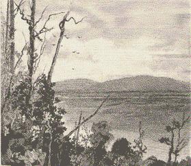 Then comes a belt of forest
timber, with many shades of green, and here and there a flash of vivid crimson, produced
by the leaves of a dead branch, with occasionally, a gleam of yellow or a streak of warm
brown or sober grey. Then a great expanse of open country, not monotonous in colour, for
in places there are patches of cultivation, green as an emerald, and elsewhere there are
others resembling sheets of malachite, interspersed with squares of faded amber, all of
them changing incessantly as the glints of sunshine chase the cloud-shadows over the
surface of the landscape. Here and there a smoothly- rounded mamelon breaks the dead level
of the plain, and at the extreme limits of the champaign to the right and left, the
undulating outline of a range of hills abases itself as it approaches the south, so as to
admit of a prospect of the bay shining like a sheet of silver in the sun while in the far
distance the Dandenongs veiled in a tender robe of mist, look like a bank of pale blue
clouds lying along the line of the horizon.
Then comes a belt of forest
timber, with many shades of green, and here and there a flash of vivid crimson, produced
by the leaves of a dead branch, with occasionally, a gleam of yellow or a streak of warm
brown or sober grey. Then a great expanse of open country, not monotonous in colour, for
in places there are patches of cultivation, green as an emerald, and elsewhere there are
others resembling sheets of malachite, interspersed with squares of faded amber, all of
them changing incessantly as the glints of sunshine chase the cloud-shadows over the
surface of the landscape. Here and there a smoothly- rounded mamelon breaks the dead level
of the plain, and at the extreme limits of the champaign to the right and left, the
undulating outline of a range of hills abases itself as it approaches the south, so as to
admit of a prospect of the bay shining like a sheet of silver in the sun while in the far
distance the Dandenongs veiled in a tender robe of mist, look like a bank of pale blue
clouds lying along the line of the horizon.
 The southern slopes of Mount Macedon are dotted with villa
residences, the highest in point of situation being also, by a piece of unusual good
fortune, the most artistic in design. Concealed among the folds of this heavily timbered
range of hills are waterfalls flowing over slabs of rock that in their regular
stratification resemble the work of Cyclopean artificers —gigantic monoliths,
isolated or in groups, that recall the huge cromlechs of the Druids; fern-tree gullies,
where the sunlight never glances on the ice-cold water that flows darkling below and
mysterious recesses of the forest almost untrodden by the foot of man. Some extensive
areas have been permanently reserved so as to prevent the drying-up of the streams which
take their rise among the wooded heights of this portion of the Great Dividing Range, and
a State nursery has also been established.
The southern slopes of Mount Macedon are dotted with villa
residences, the highest in point of situation being also, by a piece of unusual good
fortune, the most artistic in design. Concealed among the folds of this heavily timbered
range of hills are waterfalls flowing over slabs of rock that in their regular
stratification resemble the work of Cyclopean artificers —gigantic monoliths,
isolated or in groups, that recall the huge cromlechs of the Druids; fern-tree gullies,
where the sunlight never glances on the ice-cold water that flows darkling below and
mysterious recesses of the forest almost untrodden by the foot of man. Some extensive
areas have been permanently reserved so as to prevent the drying-up of the streams which
take their rise among the wooded heights of this portion of the Great Dividing Range, and
a State nursery has also been established.
Northward from Woodend, on the main trunk line, is Carlsruhe, and from
this village —a farming centre in the midst of an agricultural district
—branches off a railway to the west; on this line the first station is the
flourishing village of Tylden, where the splendid quality of the soil has led to large
areas of it having been brought under cultivation, with apparently the most satisfactory
results. Further on is Trentham, a mining settlement, which lies upwards of two thousand
two hundred feet above the level of the sea, and about two miles from the station are the
Falls. The way thither lies along a tolerably well-defined bush track, and the roar of the
cataract is heard for some distance before it is reached. In the winter months, when the
river Coliban is in full flood, a great body of water leaps over a broad ledge of rugged
rock into a chasm about ninety feet below. The shelving banks above and the precipitous
sides of the pool which foams and eddies in the depths beneath, are covered with trees and
shrubs; while the spray, which rises like a diaphanous cloud of silvery mist keeps them in
vivid and perennial verdancy.
In the neighbourhood of the Falls, and in fact throughout the heavily
timbered ranges which are characteristic of the country bounded by the Daylesford railway
line, the river Loddon, the Kangaroo Creek and the Coliban, are numerous sawmills. The
roads are often little more than gashes scored on the earth’s surface by timber
waggons and log-jinkers.  Almost
everywhere in this thickly wooded region are to be heard the resonant cracking of
bullock-whips, the voices of teamsters urging their cattle to strenuous effort in some
desperate pinch, the ring of the axe through the echoing forest, the crash of felled
trees, the clinking of crowbars, the note of the solemn bullock-bell —as though from
some far-distant convent in the hills —the whirr of the circular or the steady
rasping sound of the vertical saw, and the laborious panting of the engine which gives
power to the machinery. A few years ago the timber-getters reigned here supreme, but the
agriculturist is fast following in the wake of these pioneers of settlement.
Almost
everywhere in this thickly wooded region are to be heard the resonant cracking of
bullock-whips, the voices of teamsters urging their cattle to strenuous effort in some
desperate pinch, the ring of the axe through the echoing forest, the crash of felled
trees, the clinking of crowbars, the note of the solemn bullock-bell —as though from
some far-distant convent in the hills —the whirr of the circular or the steady
rasping sound of the vertical saw, and the laborious panting of the engine which gives
power to the machinery. A few years ago the timber-getters reigned here supreme, but the
agriculturist is fast following in the wake of these pioneers of settlement.
Yet sounds such as those described above, and sights, not altogether
unpicturesque, of red-shirted axemen and bullock-drivers with leathern belts about their
waists supporting their due accompaniment of pouches, and hats broad in leaf and
unconventional in fashion upon their heads —smoking always and swearing oft, still
attest the vigour of an industry which in this rich productive soil is always succeeded by
the less exciting, and also in a measure less picturesque, occupation of the tiller of the
soil. Before the railway from Carlsruhe to Daylesford was constructed, a private tramway,
built at immense cost, conveyed the timber cut at one of these sawmills to the main road.
For miles it threaded its way through the silent forest —bridging a stream, skirting
a hill, or keeping its level by countless windings along creek-beds. The giant gums
towered above it, and in times of storm the wind sometimes dropped a branch or flung a
forest king across it. The wild flowers and the native grasses, the bush heather and the
woodbine called orange blossom, clambered about the supports and peeped between the
interstices of the sleepers. But the tramway is now superseded, and, like the quaint huts
of old settlers in the bush, is fast falling into decay. The heart of this timber-getting
country is about the basin of the Loddon —from the settlement of Glenlyon, through
Springhill and Little Hampton, to Lyonsville, and, on the other side of the railway line,
about the spurs of the Great Dividing Range, at the head of the Blind Creek, at Blue
Mountain and farther out towards Blackwood, which is also a mining settlement, although
not now so flourishing as in times past.
From Trentham to Bullarto the railway passes through a forest in which
the undergrowth is so thick as to resemble a jungle; but where cuttings have been made, a
rich chocolate soil is disclosed lying on the surface from two to four feet deep. At
Bullarto the line reaches its highest point of elevation, being two thousand four hundred
and fifty-two feet above the sea level. A good many selections have, been taken up near
the station and large quantities of firewood and palings are stacked awaiting,
transmission to market. The railway descends a couple of hundred feet before reaching Musk
Creek, a rudimentary settlement where a considerable area of fine agricultural land has
been reclaimed from the forest, and is now being, brought under cultivation. A marshy
creek, almost hidden by the trees from which it derives its name, flows at the foot of a
pretty green knoll on the left-hand side of the line, and it requires no gift of prophecy
to predict that this will one day form the public park of a prosperous country town. Three
miles farther on, the railway reaches the important town of Daylesford, which must
eventually become the Matlock, Pau, or Baden Baden of Victoria, its topographical position
and the great therapeutic value of its mineral springs designating it as one of the great
health resorts of the future.
 Situated at an altitude of two thousand feet above the level of
the sea, and surrounded by mountain scenery of a magnificent character, the place only
requires to be better known in order to attract a crowd of visitors from Melbourne,
Sandhurst and the Riverina district during the summer months, when the nights are always
cool in this region and a fresh breeze descends upon it from the appropriately named Mount
Blowhard. Daylesford owes its origin to the auriferous deposits which are met with in a
belt of fractured rocks less than a mile wide, but stretching uninterruptedly both north
and south for several miles in length. These are being worked by numerous companies, one
of which has driven a tunnel half a mile long through the bowels of the earth. Owing to
the undulating nature of its site, the general aspect of the town, as seen from a little
distance, is quite picturesque, and the bell tower of the fire brigade, the cupola of the
State school, the spire of the Wesleyan church, the poppet-heads of the North Cornish
mine, the gables of the Episcopalian church, and the crown of evergreen trees on Wombat
Hill group themselves effectively against the sky line when surveyed from the pleasant
eminence upon which the public park and racecourse have been established, a creek winding
through the valley below, with a wooden bridge thrown over it, filling up the foreground.
Situated at an altitude of two thousand feet above the level of
the sea, and surrounded by mountain scenery of a magnificent character, the place only
requires to be better known in order to attract a crowd of visitors from Melbourne,
Sandhurst and the Riverina district during the summer months, when the nights are always
cool in this region and a fresh breeze descends upon it from the appropriately named Mount
Blowhard. Daylesford owes its origin to the auriferous deposits which are met with in a
belt of fractured rocks less than a mile wide, but stretching uninterruptedly both north
and south for several miles in length. These are being worked by numerous companies, one
of which has driven a tunnel half a mile long through the bowels of the earth. Owing to
the undulating nature of its site, the general aspect of the town, as seen from a little
distance, is quite picturesque, and the bell tower of the fire brigade, the cupola of the
State school, the spire of the Wesleyan church, the poppet-heads of the North Cornish
mine, the gables of the Episcopalian church, and the crown of evergreen trees on Wombat
Hill group themselves effectively against the sky line when surveyed from the pleasant
eminence upon which the public park and racecourse have been established, a creek winding
through the valley below, with a wooden bridge thrown over it, filling up the foreground.
The botanical gardens in Daylesford enjoy a position which is altogether
unique. There is nothing resembling it in Victoria. They occupy the summit of a round and
isolated hill two thousand three hundred feet above the level of the sea, the name being
derived from the numerous wombats which burrow in its rich chocolate soil. It has been
planted with groves of pine, cedar, laurel, juniper and pittosporum, and these have been
so disposed as not to obstruct the outlook of the visitor over one of the finest and most
extensive prospects the eye could desire to gaze upon. As far as vision can reach in every
direction, ranges spread out, ridge over ridge, like the billows of some vast ocean that
has been abruptly solidified in the midst of a raging storm. In their interspaces, the
spectator perceives green plains and fertile bottom lands upon which agricultural
settlement has taken place, with an occasional sheet of mist overlying a moist valley and.
resembling a great lake or inland sea. The town of Maldon is discernible in the far
distance, as well as the mining towns of Vaughan and Fryerstown, with Hepburn nearer at
hand; while the whereabouts of Sandhurst, Castlemaine, Kyneton, Malmesbury, Taradale,
Kingston and Smeaton is, to anyone familiar with the topography of the immense expanse of
country comprehended in. the view, denoted by their contiguous hills. In many instances
the summits of the mountains present a succession of flowing lines, and they are
singularly beautiful in colour owing to the lucidity of the atmospheric medium through
which they are seen. The ranges in the far distance —and these include the Grampians,
the Pyrenees, Mount Alexander and Mount Tarrengower —are more rugged in outline, and
several of them have serrated peaks. Some of the nearer hills are clothed’ with
timber, while others are carpeted with green sward to the very top. What lends a special
interest to the scene is, that at some, far distant epoch the whole region was one of
great volcanic activity. Wombat Hill itself vomited forth the greater part of the lava,
ashes, scori� and tufa which form the ingredients of the fertile soil at its feet. Mounts
Franklin and Bullarook, and Fern, Lightwood, Snake, Kangaroo, Bald, Eastern and Smeaton
Hills were once throbbing with internal fires, and sent up their columns of flame and
smoke and incandescent minerals into the heated air. To-day, the circumjacent valley to
the north, south and east is a land literally flowing with milk and honey. In winter its
lush verdure is inlaid with squares of ruddy brown and deep black where the earth has been
turned up by the shining ploughshare; in the autumn these are bright with golden grain. In
the orchards and gardens all the English fruits thrive luxuriantly, and large quantities
of strawberries, raspberries, black currants and other produce find their way to the
Melbourne market, where they are highly appreciated.

On the western side of Wombat Hill the town is seen deploying its
rectangular streets towards the rising ground opposite, where villa and cottage residences
have been erected upon jutting knolls and eligible ledges. The principal churches —of
which the Episcopalian and the Roman Catholic are not without some architectural
pretensions —are well placed upon the hitherward slope; and the handsome municipal
hall is a conspicuous feature in the town itself. Daylesford is supplied with water from a
reservoir of eleven acres, which receives a pure mountain stream, and at Bullarto, seven
miles distant, is well stocked with fish. Mineral springs abound in the immediate
neighbourhood; those at Hepburn resemble in their composition the celebrated waters at
Schwalbach, Spa and Cheltenham, and appear to be extremely beneficial in cases of atony,
dyspepsia, gastric fever, and liver complaints.
The neighbourhood of Daylesford teems with waterfalls, those of Stony
Creek and Sailor’s Creek being but a morning’s walk from the town. The road to
the first lies through a pretty bit of bush scenery, where tall saplings have already
sprung up to conceal the scars inflicted on the face of nature by the diggers, whose
abandoned shafts gape at the wayfarer like so many open graves. Springs issue from the
gravelly soil, and a wooden bridge crosses the creek just before it leaps over a platform
of lock, about fifty feet high, into a ravine flanked by steep banks and in places by
rugged escarpments.  Close by is
what was once an hotel, from which all the custom has ebbed away; and there are a few
cottages in the neighbourhood inhabited by Italians who still cherish fond memories of the
"land of the citron and myrtle," and whose hearts warm to the stranger who can
speak to them in their own tongue of the smiling plain of Lombardy and the lovely, shores
of the Maggiore, from which, and from the Ticino, most of them seem to have emigrated.
Close by is
what was once an hotel, from which all the custom has ebbed away; and there are a few
cottages in the neighbourhood inhabited by Italians who still cherish fond memories of the
"land of the citron and myrtle," and whose hearts warm to the stranger who can
speak to them in their own tongue of the smiling plain of Lombardy and the lovely, shores
of the Maggiore, from which, and from the Ticino, most of them seem to have emigrated.
Pursuing a broad bush track, still encumbered with the butts of the
trees which have teen felled, and with the gaunt skeletons of those which are awaiting the
woodman’s axe, the falls of Sailor’s Creek can be reached in a journey of less
than two miles. Here two small streams —separated by a massive promontory ‘of
rock, fissured and seamed so as to resemble the rough masonry of the old Etrurians
—descend into a gorge, upwards of a hundred feet deep in places, enclosed between
walls, of massive boulders, beautifully stained with mosses and lichens. These cliffs are
supplanted, a little farther on; by steep and thickly wooded banks, at the bottom of which
flows the stream formed by the junction of the two falls. But its waters if audible are
invisible, owing to the dense undergrowth of lightwood, sassafras, pittosporum, cherry and
other trees, and of shrubs which flourish in a humid habitat. A small wooden place of
worship occupies a shelf of rock between the outfall of the two creeks, and looks down
upon a scene of singular and romantic beauty.
Besides the Trentham or Coliban Falls already referred to, which can be
reached in little more than an hour from Daylesford, there are those on the Kangaroo
Creek, six miles distant, and the Loddon Falls, which are within a mile of the coach road
to Malmesbury. The ride to this town is in the winter months performed after dark, and the
impression it leaves on the mind is somewhat phantasmagoric. The country is extremely
hilly during the first part of the journey, and much of it is covered with timber, so that
an endless procession of weird-looking trees seems to defile silently past the spectator,
with here and there a burning trunk to cast a fitful glare upon the encompassing darkness.
 The coach halts at
Glenlyon, a small township on the Loddon, which here flows at the foot of a serpentine
range, and on the other side is a tract of good agricultural land, quitting which, the
road crosses a high ridge and then passes almost in a straight line through a valley about
a mile wide, hemmed in on each side by ranges, but opening out somewhat as it reaches
Malmesbury. This is a thriving town prettily situated on the Coliban, the waters of which
here flow into a reservoir capable of storing two thousand eight hundred and forty million
gallons of water for the supply of Castlemaine and Sandhurst. Surrounded by a large area
of agricultural country and possessing gold-bearing quartz reefs, alluvial deposits and
extensive stone quarries, Malmesbury is a progressive place, with four churches, a town
hall, several hotels’ a couple of banks, a State school, a mechanics’ institute
and library, a racecourse, and public gardens. Southward from Malmesbury, lies Kyneton, at
a distance of seven miles by railway.
The coach halts at
Glenlyon, a small township on the Loddon, which here flows at the foot of a serpentine
range, and on the other side is a tract of good agricultural land, quitting which, the
road crosses a high ridge and then passes almost in a straight line through a valley about
a mile wide, hemmed in on each side by ranges, but opening out somewhat as it reaches
Malmesbury. This is a thriving town prettily situated on the Coliban, the waters of which
here flow into a reservoir capable of storing two thousand eight hundred and forty million
gallons of water for the supply of Castlemaine and Sandhurst. Surrounded by a large area
of agricultural country and possessing gold-bearing quartz reefs, alluvial deposits and
extensive stone quarries, Malmesbury is a progressive place, with four churches, a town
hall, several hotels’ a couple of banks, a State school, a mechanics’ institute
and library, a racecourse, and public gardens. Southward from Malmesbury, lies Kyneton, at
a distance of seven miles by railway.
cont...
click here to return to main page