What's new ?, Trends
Paper on GIS application to support national land affairs


Conference on 'The Role of Geographic Information System (GIS) for Enhancement of National Spatial Planning' in Jakarta on October, 21-22, 1996

Geographic Information System (GIS) Application for Support the National Land Affairs

Assessment and Monitoring of Land Use through GIS as a Decision Tool for Land Use Planning:
ILUD - Indonesian Land Use Databank at BPN

by G.Bechtold, Consultant Team Member of LREPP-II/B


Keywords: Land use planning, GIS, BPN, land use mapping, land use monitoring, ILUD, land allocation, automation, standardization, GIS production

Abstract: Land use planning is a crucial process for appropriate, economic and sustainable land use. This includes involvement of GIS, to cope with the urgency of request, the need for a spatial pattern and the large amount of data. In a decentralized, multi-sectoral agency setup, the National Land Agency (BPN) has the mandate to allocate land use under a 'spatial land use management plan'.
In the framework of the LREPP-II project, an automated, customized GIS and database system for land use mapping, land use monitoring and land allocation has been setup: ILUD, Indonesian Land Use Databank. It includes user-interfaces, standardization and convention codes.
Technical details such as land use mapping methodologies, procedures, standards and conventions are explained.
To enable a decentralized production line of GIS produces, general attention has to be drawn on adjusting GIS on available human resources assessment, on shifting GIS discussion from technology to decision support function, and on standardization and automization.
Main target of this ILUD system is to support decision makers at defining land use plans, and to implement and to monitor land use changes after land use planning.


Introduction

Land resources are limited and finite. With the increase of the population of Indonesia, there is a strong, urgent need to match the land resources with the land use in the best way, so as to maximize the sustainable production and to satisfy the diverse needs of the Indonesian society, while conserving fragile ecosystems and the Indonesian heritage.

Land use planning is fundamental to this process. With the support of Geographical Information Systems, the decision making on land use planning, implementation and monitoring can be executed faster and more reliably - `better', as more data can be processed in a faster way. On any level of decision, executives need instant access to reliable spatial data. This includes information of the current land use, and land use as it can - or must - be changed, down to the size of units of individual parcels.

1) Land Use Planning

There is bound to be conflict over land use. The demands for agricultural land, forestry, urban development, industrial expansion, tourism, wildlife, etc. are greater than the land resources available. These demands become more pressing every year. Even where land is still plentiful, many people may have inadequate access to land or to the benefit from its use, or resources are not being used efficiently. Where scarce, the degradation of agricultural land, water resources or forest is clear for all to see, but difficult to stop.

Land use planning is the process to assess the potential of land and to define alternatives, in order to select and adopt the best land use options, and to implement and monitor these new land use options.

The final goal of land use planning is to put those land use recommendations into practice that will best meet the needs of people while safeguarding resources of the future.

There is a strong need to develop Indonesia in a coordinated way, that the land can support both the current need of its people as well as in the future in an economic, sustainable, ecologically sound way.

There are many publications on this issue. A lot of experience has been gathered both in Indonesia and in many other countries of the world. Beside the regional and country specific differencies, there exists a kind of a standard approach to land use planning, which promotes such a requested development. This standard approach has been discussed many times, has been outlined and explained in many publications, has been applied many times. In particularly, FAO has been very active in defining a framework and guidelines for a land use planning procedure.

Therefore, the framework should not be the topic of this paper. Indeed, as we will talk about the use of Information Systems in Indonesia at the land use planning approach, I shall only summarize the conceptual steps of improvements towards a land use system, where land is being used economically and sustainably, relatively unharmed by environmental impacts.

  • Need to change, need to improve
  • Assessment of potential of land
  • Physical land evaluation
  • Present land use
  • Socio-economic land evaluation
  • Assessment of land status and ownership
  • Development policies
  • Land use plan
  • Spatial land use plan (for implementation){through land use zoning}
  • Implementation and land allocation
  • Control and monitoring of land use plan and of land use changes

Fig.1: Concept of Land Use Planning

Land use planning becomes a `re-engineering process', where the present status- quo (with the current land use) is the starting point, and the future, planned land use with the implemented land use changes is the target.

In the past, it was possible to draw these concepts manually and with much emphasis on existing long-term expertise. Now, pace of development has changed: It is much faster, need for appropriate land use planning is stronger and more urgent, mainly for three reasons:

  • - High population number and high population growth, particularly in urban areas,
  • - Fast development of technologies (industry, infrastructure etc.),
  • - Strong impact of catalysts and large number of interactions in the field of development.

Thus, requests to land use planning institutions are more urgent. Appropriate land use plans have to be formulated much faster. Efforts to ensure their implemention and monitoring become more important. There is a `move towards more flexible type of planning. Planning procedures have to be established to be more responsive to dynamic situations.' (Ir. Soni Harsono, State Minister of Agrarian/BPN, 21/10/96).

Therefore, a fast, comprehensive, digital approach should be applied.

GIS supported information function can help at some of the above mentioned steps. It is indicated in the chart above, where support functions of GIS are possible and can help in the land use planning procedure. This is particularly true at those steps where:

  • - large amount of data has to be processed, or
  • - different scenarios with different interactions have to be modelled and tested, or
  • - a considerable amount of map display and printing is necessary within tight time constraints.

This shows the importance of current and future land use assessment, and - in combination with the above mentioned urgency of land use planning efforts - on a digital approach with information systems.

GIS provides a foundation for the planning and implementation of development which is sustainable in environmental and social terms. Modern planning methodologies require multi-sectoral analyses and these in turn require a broad and up-to-date database. `Improving the quality of the information supplied to planners, policy and decision makers will improve the quality of planning and implementation of development oriented activities' (Ir. Soni Harsono, ibd).

`Land use planning will never be a fully automized process, but the human decisions can be efficiently supported, based on a solid database. ... Mistakes will be reduced and decisions might become more transparent for everybody involved in land use' (Bartels, LUPAM, 1993).

2) The Role of the National Land Agency (Badan Pertanahan Nasional)

Due to the complex structure of land use planning, to the size of Indonesia, and to the heterogenous land use patterns, the task of land use planning had to be delegated to and managed by various Government bodies. Thus, various institutions deal with the planning, partly based on policy matters, partly based on natural resources assessments, for example Bappenas, Bappeda, Bangda, PU, etc. They all form an integrated part of land use planning and conceptually follow the outline above. Such a decentralization in sectoral aspects is necessary in a country like Indonesia.

To avoid overlapping and to enable a smoother flow of decisions and of data for data sharing among sectors and agencies, coordination is extremely important between all the concerned agencies, both in the field of delegating tasks and functions of land use planning as well as in the field of data exchange.

In technical terms, data have to be compatible and portable (between the different platforms and software) on a preset defined quality level, and institutional exchange of data has to be established and made easy.

As it was outlined by the Minister, the National Land Agency (BPN) has an important strategic position in this mosaic of land use planning. BPN is the authoritative body responsible for the national land administration and all other related issues, consisting of land use, land tenure, land rights, and land regulations. BPN also plays an important role in the execution of the spatial planning process on national, provincial, and district level.

BPN inter alias is responsible for the issue of location permits, which are based on the spatial plan for enterprises within the framework of capital investment and monitoring thereof. For the process of spatial planning, BPN contributes to BAPPEDA with data on present land use and proposals of land allocation plans and legal aspects for land ownership, to avoid social problems due to misuse of land.

Where do these functions and mandates come in to the picture of land use planning ? The answer is: At all points, where the actual - current or future - land use is taken into consideration.

This is not the case at the definition of general land use planning policies, where other agencies play an important role, but rather at the implementation of land use plans.

This indicates that the implementation of land use plans has to be stimulated and controlled with BPN's assistance and input, in particular in areas where ownership of land has a strong impact on the land use and its management ! Mechanisms and tools for the implementation of these components of the land use plan are the forementioned mandates of BPN, such as land titles, land rights, land regulations, land use concessions, izin lokasi etc.

But it is not only the implementation in form of giving land use concessions to potential users, it is also the `follow-up, i.e. the monitoring of giving these land use concessions and of the land use changes which can be observed and the control for their legacy. A legal and regular monitoring system ('land use change detection') has to be an integrated part of land use planning.

Potential land use conflicts can only be satisfactorily solved by a strong institution with all necessary mandates and with clear decisions based on reliable data which can be accepted by all parties !

Thus, with the wish to establish a satisfactory, peaceful, political and social environment, without invoking quarrels over land use conflicts, BPN has to carry out its mandate, based on a transparent decision structure with reliable, transparent, up-to-date, spatial data !

Therefore, it is of utmost importance to strengthen BPN on two aspects:

  • - In the political environment, BPN working together with all other institutions as well as individual land owners and land users, with all BPN's mandates, and:
  • - In the technical field, to have BPN capable and operational to assign land use and land use concessions in the framework of land use plans which have been agreed on, which are seen in a socially justified and rightful context, and which are fully based on correct and reliable data and procedures.

The data being necessary for BPN to implement its important political and social function, are called 'spatial land use management plans': Maps ('spatial') which indicate the future situation ('plans') according to the policies given by the responsible planning institutions (Bappeda etc.) of the land use and its management, including land owners ('management').

And last, but not least, is the starting point with the inventory of the current land use on a rather detailed level of detail, which is from detailed mapping of land use classes for macro-level land use assessment down to inventory of land parcels, ownerships and land use concessions at the micro-level land use planning, where BPN is involved.

In the further presentation, reference and explanation shall be given to these particular tasks of BPN. Using the graphic above, the particular functions of BPN - in the sectorally decentralized point of view - are highlighted.

Fig.2: BPN's Role at Land Use Planning

In summary, the role of BPN is to promote land use planning with the support of GIS and:

  • - to assess land use for definition of land use plans, land concessions and titles
  • - to monitor land use as a tool to control land use plans and land concessions.

3) GIS in Land Use Planning at BPN

At most of these functions, information systems can considerably help the decision makers with a well based, well interpreted information set.

As decision makers, both BPN management (for land use concessions, land use rights etc.) as well as management, control and auditing bodies outside of BPN (for definition of land use plans, land use plan implementation, interpretation of land use monitoring during and after land use planning efforts, etc.) are to be understood.

There are many advantages of digital inventory and interpretation of land use data for land use planning, as outlined in the previous sections and by other participants in this conference: The system is fast, easy to modify, capable of running different scenarios and models, can store large amounts of data, flexible for individual, specific requests and retrieval, can be accessed in many places simultaneously, can be updated with new data types and data sources within very short time, etc.

On the other side, it shall not be ignored, that there are potential disadvantages as well:

  • - It depends on information technology (which itself is not a disadvantage, but it requires technology skill).
  • - It initially requires higher training input, thus there can be a lack of trained manpower, and it needs a 'user-front-end of software': Therefore the system has to be set up in a user-friendly, easy-to-operate way.
  • - Data entry: Process of data entry has to be done as easily and as efficiently and with as little error as possible.
  • - Costs of hardware and software required: Affordable systems and platforms have to be looked for, rather preferring PC than UNIX workstation, if possible.
  • - Establishment of new procedures and methodologies: An integrated system has to be developed and tested, and staff to be trained.
  • - Conservative policies of some government institutions: An 'educational' process is necessary, users have to become aware of the advantages, facilities and limitations.
  • - Problems of data in different formats agency specific and under the aspect of data sharing: One system, one structure, one standard to be agreed on, which is `transparent' and compatible with other agencies' systems.

Most of these `disadvantages' can - and have to - be overcome by coordination between the various sectors being involved. Thus, coordination is important in any land use planning effort, but even more in land use planning with digital data.

At BPN / PGT (`Deputy II'), various GIS efforts have been made to establish a system. Great achievements have been made in the past years on the way to support the decision makers with the required data set.

To mention here only the Land Resources Evaluation and Planning Project LREPP-II in a joint framework with Bakosurtanal, Puslittanak, and Bangda, funded partly by loan of the ADB, the Land Use Planning and Mapping Project LUPAM by German bilateral aid, and Government funded GIS projects at the Deputy for land use mapping. Additionally, there are more GIS projects at BPN at the Deputy for cadaster, as presented earlier.

The concept of setting up a digital database has been very much accepted by the decision makers through these projects. Awareness has risen, advanced and detailed discussions have come up for nationwide implementation, application, standardization, conventions, structurization of a GIS system, and have mostly been settled.

One result of these efforts is the establishment of the `Indonesian Land Use Databank' ILUD, which has been set up in the frame of LREPP-II, based on those discussions and previous experiences in BPN / PGT.

4) LREPP

A second phase of the 'Land Resource Evaluation and Planning Project' was set up and started mid 1993, and is now near completion. The fundamental idea is to have a coordinated approach (as formulated earlier) between four main agencies dealing with land use planning or with efforts to establish and gather data for land use planning, to develop `an overall national programme to strengthen the database, processes, institutions and skills for land resource evaluation and planning.' The objectives of LREPP-II were:

  • - to extend the Geographical Information System (GIS) at the national and provincial levels, and
  • - to improve the physical planning process in the 18 provinces of the project to maximize the benefits to be obtained from the optimal use of land resources and natural resource management.

The above mentioned four agencies are:

  • - Bakosurtanal for base mapping and the national geographic land resource information system,
  • - BPN for land use mapping,
  • - PUSLITTANAK for soil resource mapping,
  • - BANGDA for provincial planning.

Each of those 4 agencies have well defined ToR.

The main purpose of LREPP-II/B at BPN was the `institutional strengthening, assisting BPN in the development of the capability to appy modern methodology and technology to land use mapping and monitoring, while producing the land use maps required for planning and monitoring in the priority areas'.

Thus,

  • - BPN has to be strengthened as an institution which applies new technologies,
  • - A methodology has to be developed, tested, and applied,
  • - Technology has to be transferred, and training given to the staff members,
  • - 4 Mio. ha of priority areas have to be surveyed, digital data have to be made available.

This is near completion:

  • - A databank system has been defined (ILUD, see below for further technical details),
  • - The priority areas have been mapped with data sources of aerial photographs, field work and, partly, satellite images at the scale of 1:50,000 and 1:25,000 (Jawa, Bali), totalling up to 4 Mio. ha in 18 provinces,
  • - Maps have been digitized and can be plotted,
  • - Staff in 18 provinces has been trained,
  • - Technical manuals for documentation and for training and for user's application have been written.

These experiences can be used for a nationwide approach to inventor land use data for land use planning.

Fig.3: Regional Setup of LREPP-II

Fig.4: Monitoring Result of Availability of LREPP-II Maps of Land Use (automatic retrieval)

5) ILUD

The first point to be mentioned, is the setup of a methodology for the production of land use maps and their interpretation for the purpose of land use planning. This is seen as an integrated package which enables easy switching between the individual components, under the main objective of producing structured data in large quantities, which can be directly used for land use planning.

Preconditions for such a system and its development were:

  • - User-friendliness: Except a very few permanent power-users of GIS, most of the users (technical staff to enter and compile data, or management to retrieve or query data) are not permanently working with GIS applications. Thus, processing steps and commands have to be easy, or even (as far as possible) automatically executed. Command line level was not acceptable.
    A human resource assessment (HRA) is nowadays one of the most important tasks before setting up, selecting or developing an information sysem. The result of our HRA is a user interface, which is applicable at all BPN offices, which will be shown below.

  • - Standardization: Even though many different provinces are setting up their GIS systems, it can not be accepted, that in all those many offices, different codes, different technical approaches, different file names, different file structures etc.etc. are being applied. In such a case, data can not be transferred from one province to another, not to Pusat, and not to other agencies. If data can not be used and can not be transferred to other users, they are considered as being useless.

  • - Performance: To fulfill the requests of fast, reliable, transparent data processing to satisfy and to support the decision makers in their difficult task of land use planning, it is obvious, that such a system has to run smoothly, can cope with large amount of data and that it can perform much faster and more precisely than the manual approach: 'We talk about hours rather than weeks' for the digital work !

Over the past two years, with many discussions and meetings and a lot of feedback from the provinces and the regions, a system has grown, which fulfills these preconditions, and which shows full viability.

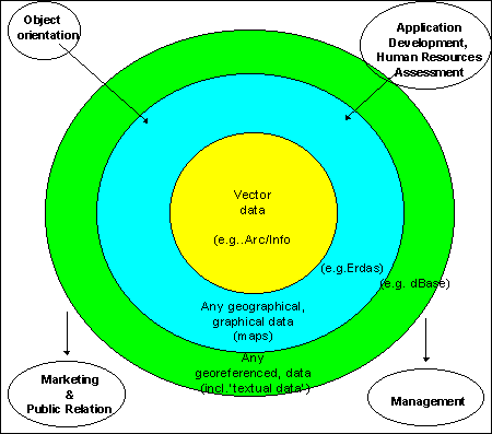
This system ILUD ('Indonesian Land Use Databank') consists - in data and software terms - of three components:

  • - GIS component (with Arc/Info),
  • - DBMS component (with dBase data files), and
  • - remote sensing component (with Erdas).
In broader terms, the entire system can be called a GIS, a 'Geographical information system', but some people might prefer to use the term to a vector based, one-software operated GIS.

Fig.5: Various GIS Definitions

The results of these considerations for the application of any institutionalized, fully established, professional information system are expressed in the following chart:


    ILUD = Concept to collect, process and interpret land use data
    ILUD = Common data standards, structures and conventions
    ILUD = Software for user interfaces
    ILUD = Standard output
    ILUD = Marketing strategy
    ILUD = Contribution to appropriate land use planning

5.a) Concept:

The general outline can be displayed graphically. Essential for land use planning are outputs such as maps (and textual data) on land use, land evaluation, land status, land allocation and land use monitoring. Data input, which has to be discussed at this stage of setting up a concept, consists of satellite images or alternatively aerial photographs, field work (being very important for detailed and semidetailed land use inventory!) and external data such as topographic maps, census data etc.

Fig.7: General Concept

Fig.8: Detailed Land Use Mapping Concept with ILUD Cycle for Assessment of Current Land Use

To control the land use plan implementation, a monitoring of three aspects has to be undertaken:

  • 1. In areas, where the land use plan foresees (recommends or allows) land use changes, to make use of the land in a more efficient and more sustainable way:

    These areas have to be monitored, to see if the recommended or allowed land use change was implemented according to the land use plan and in accordance with the permission for land titles - for the project and plan monitoring and occasionally even for tax purposes.

  • 2. In areas, where the land use plan does not recommend nor allow any land use changes:

    It is important to monitor these areas on a regular basis to see that no illegal land use change takes place, ie. without permission.

  • 3. In areas, where the land use plan enforces land use change, to keep the land sustainable, eg. due to environmental impacts:

    These changes have to be monitored for their implementation.

Conceptually in GIS terms, this is an overlay with three layers: One of the land use with the previous situtation (eg.before the declaration of the land use plan), one of the present land use, and one of the land use plan.

In technical terms, the detailed concept can be described as follows:

Land use survey:

    In the case where aerial photos are the primary data source, aerial photo interpretation will be undertaken with delineation of `API units', followed by field work, where for each mapping unit 1-10 samples are taken. The delineation of API will be digitized (using module ILUDArc), the polygons will be identified (`labeling' with module ILUDLab). The field data are entered in the DBMS with ILUDEntr , processed with ILUDProc and then linked with the GIS data through ILUDLab.
    In case of satellite images, preprocessing of the scenes will be done in Erdas Imagine with ILUDRs and spectrally classified. After conversion to vector format to the GIS (with module ILUDR2v), the further processing is identical to above described procedure from the aerial photo interpretation, including the `labeling' for land use classification, field work, and field data entry.
    Data will be stored in lat/long reference, and can be plotted (with ILUDPlt) in a standard map layout based on the national grid system or based on administrative boundaries, e.g. for Kabupaten or Kecamatan (with preparation through ILUDAdm).
Land evaluation:
    It basically follows the concept of FAO's framework for land evaluation, with the definition of land utilization types, land characteristics, and land qualities. The relation of these models will have to be designed. As data sources, geomorphological (including altitude), climatic, land use, and infrastructure data will be used. For user-friendly application, high performance and standardized output, a macro system to execute land evaluation, ie. to assess the suitability in terms of suitable and unsuitable classes for specific land utiliztation types is being developed and applied with module ILUDKes (kesesuaian: evaluation).
Land status:
    This is very similar to the land use survey as explained above, but with additional field work involved. With a preliminary interpretation and orientation with satellite scenes and/or aerial photographs, surveyors go the field and record their findings in field data sheets. These will be entered in the DBMS, geographical boundaries will be digitized in the GIS. In the same way as with the land use surveys, these data sets will be linked through ILUDLab.
    Land status maps and land use maps (and eventually land suitability maps) can be overlaid, statistics can be retrieved from such overlays (with module ILUDStt).
Land use monitoring, ie. land use change detection:
    This process is seen as an instrument to check the change of land use versus the legal aspects of controlled assignment of new land use. Module ILUDMon monitors the land use change detection.
Quality control:
    A scheme with error assessment, error acceptance levels, quality assessment and quality assurance has to be applied for all developed methodologies as well as for all data. Many `formal data integrity checks' are built in the system !

All those concepts have been developed to support BPN to the optimum in their allocated tasks. It should not be confused that this would be the operators' level and the user-friendliness, as postulated a few pages before.

5.b) Common data structures, standards and conventions:

The next, more technical level after the 'concept level' just presented, is the guarantee that all GIS data are in a well structured, transparent system.

If an information system is to be established nationwide, in 18 or 27 Provinces, eventually in 298 Kabupaten offices, there exists a high danger that staff in those many offices will develop their own ideas upto that point that in every office different codes and different data 'systems' will be used. It even has happened that in the same office, from operator A to operator B, no exchange of data was possible ! This had to be prevented by any means !

All data entry and processing operations now follow the same procedures (i.e. the concept), have the same coding (eg. land use classification codes, road classification codes etc.), follow the same file naming syntax, have the same file structure in each component, geographical references are unique, their map sheet numbering system is structured and geometric, etc.

All this is 'transparent': Any data user and data owner of BPN / ILUD data can have a look at these standards and conventions. They are documented in software manuals, guidelines, training manuals, and are available electronically anytime by anybody through the Internet:

http://www.oocities.org/Tokyo/2439/

The land use classification is attached to this paper. This is a hierarchical, structural classification system, which can be extended for larger scales, i.e. at urban areas, and which has been defined to satisfy the requests of future users.

At a first glance, the classification seems to be rather detailed. This is due to the scale (maximum mapping scale 1:25,000) and the purpose (the need !) to use these data for land use planning. But it should be mentioned, that smaller scales normally consider less classes.

One remark on the classification: While it is important to have a standard classification that users are familiar with and can work with, it does not mean that a GIS has to rely solely on those classes. In ILUD, there is an extended textual `attribute' database (DBMS) behind the classification and behind the standard map display. This will become more important in future, when more specific requests will be made for specific land use mapping features, such as query requests for display or statistics for one specific land use type. (These data are stored in dBase dbf files, and are processed by Clipper exe routines.)

5.c) Software for user interface:

Introduction of an easy, user-friendly interface was a 'must' to establish ILUD and to give it the potential to execute all the tasks !

The above mentioned concept and standards can only be guaranteed by introduction of a user interface. All operators follow a well established sequence in their tasks of data entry, processing and retrieval. The rather complex chart of the concept comes down to an easy-to-follow, step-by-step routine:

Fig.9: Step-by-step Tasks of ILUD Cycle

It was very important to have developed such an interface with an object oriented guidance through the process (and through the various software), because software of today is very often overloaded with too many functions, which make them powerful at one side, but makes the user - and the operators and BPN staff - easily loose control of their original task and concept.

(Sample of menu)

As mentioned, it can easily happen, that people are 'dragged away' by all the nice, but rather useless pictures on-screen in true colors and with high resolution, at the 'state of art'. Through a stream-lining of the procedures as explained, this was avoided in the ILUD cycle.

Various modules have been implemented, some from the very beginning of the project, some only recently, a few other modules are presently being developed:

  • ILUDEntr (DBMS) for entry of field data
  • ILUDProc (DBMS) for processing of field data and transfer to GIS
  • ILUDList (DBMS) for listing and checking of entered field data
  • ILUDUtil (DBMS) as utility set to handle DBMS data

  • ILUDArc (GIS) for arc digitizing (for lines and polygons)
  • ILUDLab (GIS) for labeling of polygons and link to DBMS
  • ILUDPoi (GIS) for point digitizing
  • ILUDCon (GIS) for conversion between different projections
  • ILUDImp (GIS) for import of points to GIS (from DBMS)
  • ILUDExp (GIS) for export of points from GIS to DBMS
  • ILUDPlt (GIS) for plotting of land use maps on plotter or printer
  • ILUDUtl (GIS) as utility set to handle GIS data
  • ILUDAdm (GIS) to create land use maps beside the map frame

  • ILUDR2v (GIS) to create GIS coverages from raster (Erdas) images
  • ILUDMon (GIS) to monitor land use
  • ILUDKes (GIS) to create land suitability maps

  • ILUDRs (GIS) to automate digital processing of remote sensing
Table 1: ILUD Modules

ILUD runs on DOS, Windows 3.x, Windows 95 and in near future on Solaris (workstation).

5.d) Standard output:

It is extremely important that data which have been collected and entered in a database, can be retrieved and transferred (or displayed or printed) in an easy and particularly standardized way !

Only when an information system can supply the data in the way as requested by the users of the data is the system justified. If, for example, the user wants to have a look at the hardcopy map for orientation only, he shall be supplied with a hardcopy map. If the user wants to further process the data digitally, he shall be supplied with the GIS digital data (coverage).

Even among the different Provinces, or among different scales, I have seen output coming up in different layout, different colors, different file formats etc. Through a user-interfaced production scheme like ILUD this can be avoided !

We have a standard layout for hardcopy map production at the scales of 1:25,000 - 1:100,000 at DIN A0 size, following the map grid index of Bakosurtanal, with defined colors (for definitions, see homepage of ILUD), whose production is fully menu-driven.

Digital outputs of our mapping are various graphics formats such as BMP, PCX or PLT files, or the original data in their coverage, xBase, GIS file formats.

For complete and easy transfer of collected data BPN-internally and to outside users, we have an ILUD copy format. Through a few menu-driven keystrokes, the operator makes a full copy of the original data, which at the user's side can be 'imported' through an ILUD routine, or through standard commercial software (ex. Pkzip, dBase, DOS, Arc/Info etc.).

Beside the 'standard' full land use mapping, the system is capable to respond on special requests, such as:

  • Generalized maps (example, only the main land use class, or the top two land use class levels etc.),
  • Maps without labels,
  • Maps which show only particular areas of interest (example, only bare land or only industrial areas),
  • Maps which are defined by an administrative unit, not a square map grid (example, land use map of a given Kabupaten),
  • Maps with English legend.

They all can be retrieved menu-driven. More information in near future on ILUD homepage.

5.e) Marketing strategy:

To enable potential clients to make use of these maps and to integrate this information in their planning efforts, they have to be aware of these data and all these facilities.

There are various activities, intentions and plans for such `public relation' work.

Only one should be mentioned here, which is the Internet system, being now accessible by many institutions and individuals in Indonesia and allover the world. A homepage has been set up, which shows the progress achieved (with special routines to update it), the facilities of the system, the technical specs.

As mentioned before, you can reach us by:

http://www.oocities.org/Tokyo/2439/

See also the pages attached at the end for the full entry of the homepage of ILUD.

Data requests can be made through this ILUD homepage or generally through the e-mail system of the Internet. We have various e-mail addresses in ILUD and the regional offices of LREPP-II/B.

After having been cleared by BPN officials, data can be transmitted on disk or through the Internet.

5.f) Contribution to appropriate land use planning:

In such an application system with a well defined task of improving the land use with its attached land use survey and monitoring tools, it is the sole target to have a 'complete decision tool for management support for "spatial land use management planning"'. This is where the setup (the `concept') of ILUD had always been focusing.

Data gathering and plotting of a land use map can not be the final goal of a land use planning support system, and of ILUD, as outlined in the beginning, further data compilation and interpretation tools will be added in future.

And this is where technology becomes only a step in the process of defining, implementing and monitoring land use plans. Like in many other places, emphasis on the technology itself has to be reduced, more emphasis has to be given to the actual content of data and the decisions based on these data.

By making ILUD a user-friendly, robust, direct, straight-forward applicable system, this is our contribution to shifting the emphasis away from over-stressing technology, and towards an application tool for land use planning.

6) Future relevance of GIS for land use planning

As it was show, a fundamental behavioral change will be imposed on us:

GIS will be imperative for land use planning. In the not so far future, it will be clearly recognized that land use must be planned very carefully by optimizing the land use of the shrinking natural resources for a growing population. No spontaneous, exploitive and destructive land use can be afforded by the human community any longer, whether it is caused by innocence, struggling for survival or plain greed. The rules for land use will be set and monitored rigorously by planners who clearly depend on sophisticated GIS expert systems !

One of the most important future activities might be the monitoring, in particularly of `permits, the endproduct of the process of spatial planning activities ... the controlling tool of spatial planning' (Ir. Soni Harsono, ibd). Here, the users and the application developers will have to improve the decision structures as well as the data processing system.

Another important activity in the framework of sustainable land use planning is to stop the degradation of the environmental and natural resources.

Another aspect shall be mentioned again as important for the future use of GIS:

The future of the use and importance of GIS is as bright as the future of the economic prosperity of this country. The technology of GIS in land use planning has reached a high level of usefulness. It has been shown, that a system like ILUD can contribute to land use planning with supporting adequate, reliable, and up-to- date data, that it can be user-friendly, and is affordable.

But, as postulated a few minutes ago, emphasis has to shift from these techniques and data to the policies and strategies constructed, using them as a monitoring and management tool. Thus, technical emphasis must move to use of data and to data quality.

'People are easily fascinated by hardware and software for image processing and by the pretty pictures produced. Technologists prepared the maps and databases, while decision makers, politicians, government planners, and private corporations ignored them. Apart from cartography, little in the way of concrete outcome could be credited to the technologists.' (A.M.North, Remote Sensing and GIS in Asia, GIS Asia Pacific, p.22, August 1996)

We have to address the decision makers: the politicians, the planners, the investors, the `entrepeneurs', the land users, to be aware of the facilities of the system and to make use of the data - and to give constructive feedback to the managers, designers and developers of the information systems. `An increasing number of decision makers and managers have recognized that GIS technology will be essential if they are to address the expanded mandates and complex decisions they now face.'(Ir. Soni Harsono, ibd)

In very near future, it is up to the `decision makers' to use all these beautiful tools !

And then we, the `GIS experts', can ask ourselves: Are we doing enough for these `decision makers', the politicians, government bodies and corporation executives ? Their actions will finally determine whether development will be sustainable or not!


Back to Homepage