ILUD: Development of a Database Application for Land
Use Data
by G.Bechtold, Information System Specialist, LREPP-II/B
Keywords: Land use planning, GIS, BPN, ILUD, land use mapping, land use monitoring, spatial land use planning, land allocation, automization, standardization, GIS production, GIS diffusion
Abstract: In the framework of project LREPP-II project, an automized, customized GIS and database system for land use mapping, land use monitoring and land allocation has been setup: ILUD, Indonesian Land Use Databank. It includes user-interfaces, standardization and convention codes. The main components of ILUD: application of the methodology, definition of standards and data dictionaries, software modules, standard output, and the further interpretation of the data, are explained in this paper. The procedure to use digital data for spatial land use management planning is integrated in ILUD. Main target of this ILUD system is to support decision makers at defining land use plans, and to implement and to monitor land use changes after land use planning.
1 Introduction: LREPP-II/B
Project LREPP-II/B has been set up to collect data on land use in the frame of LREPP-II. 42 priority areas have been surveyed in 18 provinces with an allover area of some 4 Mio.ha. A methodology has been developed how to collect data for land use mapping from aerial photographs and from satellite images, with support of data collected in the field.
Some 250-300 land use maps have been compiled following this method. Digital data exist for all these areas. It was always considered as very important to have all work executed in a homogenous work approach and data being available in the same digital format.
This achievement is a strong base for the setup of a land use databank which will serve for land use data on a nationwide frame.
In this paper, it will be shown, what is ILUD, what ILUD can be used for, and which direction ILUD will have to be active in the coming years. The detailed procedures and techniques of ILUD processing will not be explained here: They have been presented, taught and documented in a series of manuals, publications and on-the-job training courses. For the functionality of ILUD, information is available on the Internet at address http://www.oocities.org/Tokyo/2439/.
2 Why ILUD ?
Need for homogenous, comprehensive, digital system approach
Geographical databases provide a foundation for the planning and implementation of development which is sustainable in environmental and social terms. Modern planning methodologies require multi-sectoral analyses and these in turn require a broad and up-to-date database. ‘Improving the quality of the information supplied to planners, policy and decision makers will improve the quality of planning and implementation of development oriented activities’ (Ir. Soni Harsono, State Minister of Agrarian Affairs/BPN, Conference on ‘The Role of Geographic Information System for Enhancement of National Spatial Planning’, 21/10/1996).
In the past, it was possible to draw land use maps and land use plans manually and with much emphasis on existing long-term expertise. For the future, new methods have to be applied, as pace of development is faster and the need for appropriate land use planning is stronger and more urgent.
Thus, appropriate land use data and plans have to be compiled much faster. Efforts to ensure their implemention and monitoring become more important. There is a ‘move towards more flexible type of planning. Planning procedures have to be established to be more responsive to dynamic situations.’ (Ir. Soni Harsono, ibd).
The planning and implementation of appropriate use of land has to be based on correct assessment of current, potential and future land use, and - in combination with the above mentioned urgency of land use planning efforts - on a digital approach with an information system.
GIS will be imperative for land use planning. In the not so far future, it will be clearly recognized that land use must be planned very carefully by optimizing the land use of the shrinking natural resources for a growing population. No spontaneous, exploitive and destructive land use can be afforded by the human community any longer, whether it is caused by innocence, struggling for survival or plain greed. The rules for land use will be set and monitored rigorously by planners who clearly depend on sophisticated GIS expert systems !
One fast, comprehensive, digital approach had to be applied in LREPP-II/B and in BPN/PGT, which is well defined and portable:
A ‘1-system approach’ - a system, that can be used in all provinces and produces data and output of the same standard and of the same quality, to be used by BPN or other agencies for the purpose of land use planning and monitoring.
The acceptance of standards was particularly important for following reasons:
Preconditions for the implementation of a databank were:
Above mentioned requirements were expressed to define a ‘system’, which can process the collected data for land use mapping, can execute further analysis of these data for planning procedures and which - very important ! - can handle large amount of data in a structured way: The idea of ILUD as the ‘Indonesian Land Use Databank’ was born.
Over a period of more than two years (1994-96), with many discussions, workshops, meetings and feedback from provinces and regions, a system has been developed, which fulfills these preconditions, and which shows full viability.
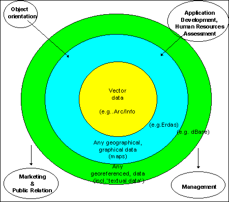
Following chart shall help to understand the idea of an instutionalized GIS:
Fig.1: Components of a GIS (Core and Frame Components)
The allover aim is to help decision makers with well based, well interpreted information.
There are many advantages of digital inventory and interpretation of land use data for land use planning, as outlined before: The system is fast, easy to modify, capable of running different scenarios and models, can store large amounts of data, is flexible for individual, specific requests and retrieval, can be accessed at many places simultaneously, can be updated with new data types and data sources within very short time, etc.
ILUD is seen as an integrated package which enables easy switching between the individual components, under the main objective of producing structured data in large quantities, which can be directly used for land use planning.
3 What is ILUD ?
Components of the System
The components of these considerations for the application of an institutionalized, established, professional information system are expressed in the following chart:
Fig.2: Components of ILUD
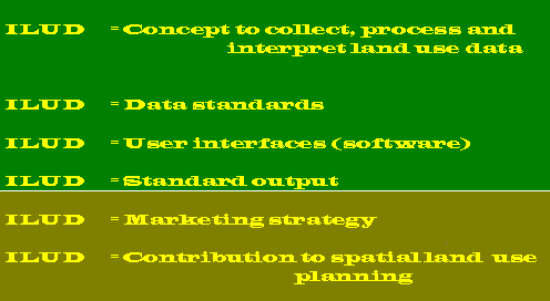
The first four components are vital for the setup and functionality of a system - and have been fully established in LREPP-II/B. The latter two are important for the appropriate use of the data and application of the system in future.
3.1 Concept:
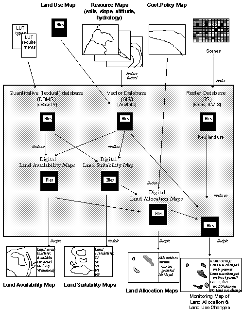
A concept is necessary at the highest level (and as the start) of any data processing activity. This has been explained by the previous speaker and shall be only summarized in Figures 4 and 5.
The methodologies are summarized in the Annex.
Fig.3: Levels of Project Execution

Fig.4: Land Use Mapping Concept (ILUD Cycle) for Assessment of Current Land Use
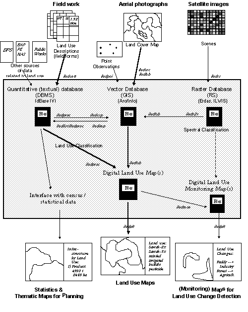
Fig.5: ‘Spatial Land Use Management’ Concept (ILUD Cycle) for Allocation of Location Permits and Its Monitoring
3.2 What is necessary for ILUD ?
Importance of Standardization
It is crucial to have classification systems as well as data dictionaries, which define codes !
‘Without standards, there is no system ! Without a system, there are no standards !’
This refers to land use data (e.g. land use classification, description of land use) as well as to non-land use data, such as road classification, etc.
For the functionality of any database, this is the most important aspect. To keep the data ‘alive’ and to make them ‘useable’, these classification systems and data dictionaries have to be used by anyone when generating and compiling the data, so the data can later be used by everybody - and not only by the staff which entered the data.
If data are not standardized, uniquely structured and catalogued with their metadata, there will be the situation of ‘having an ocean of data, but only drops of information’. It is important to guarantee that all GIS data are in a well structured, transparent system.
A standardized information system has been established nationwide. The main goal was to avoid that staff in the many offices of BPN would develop their own ideas up to that point that in every office different codes and different data 'systems' will be used. It even has happened that in the same office, from operator A to operator B, no exchange of data was possible ! This had to be prevented by any means !
Therefore, a complete set of data standards (‘Technical specs’) with definitions on:
has been defined.
All data entry and processing operations follow the same procedures (i.e. the concept), have the same coding (e.g. land use classification codes, road classification codes etc.), follow the same file naming syntax, have the same file structure in each component, geographical references are unique, their map sheet numbering system is structured and geometric, etc.
All this is 'transparent': Any data user and data owner of BPN / ILUD data can have a look at these standards and conventions. They are documented in software manuals, guidelines, training manuals,
and at address http://www.oocities.org/Tokyo/2439/iludes.htm in the Internet.
The land use classification, as the core of the data dictionary, is a hierarchical, structural classification system, which can be extended for larger scales, i.e. at urban areas, and which has been defined to satisfy the requests of future users, i.e. the purpose (the need !) to use these data for land use planning.
One remark on the classification: While it is important to have a standard classification that users are familiar with and can work with, it does not mean that a GIS has to rely solely on those classes. In ILUD, there is an extended textual ‘attribute’ database (DBMS) behind the classification and behind the standard map display. This will become more important in future, when more specific requests will be made for specific land use mapping features, such as query requests for display or statistics for one specific land use type.
3.3 How to execute ILUD ?
Software Modules
The above mentioned concept and standards can only be guaranteed by introduction of a user interface. This is the only ‘safe way’ to implement standards. The user interfaces guide (and enforce) the user to apply the standards - and not any irregular, self-defined references.
In ILUD, all operators follow a well established sequence in their tasks of data entry, processing and retrieval. The rather complex chart of the concept (see Figs.4 and 5) comes down to an easy-to-follow, step-by-step routine. The software interfaces have been developed to restrict to the necessary, essential functions, to guide in a object-oriented way through the process - and the various software.
This is highly recommended because many (GIS) software packages of today are overloaded with functions, which makes them powerful at one side, but dangerous on the other side for the institutionalization by an agency. Staff will be inclined to ‘play around’ with too many functions, and loose the view on their task ! It can easily happen, that people are 'dragged away' by all the nice, but rather useless pictures on- screen in true colors and with high resolution, at the 'state of art'.
Such a stream-lining of the procedures is necessary in an implementation and production scheme.
Fig.6: Application Setup of ILUD
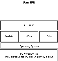
Beside the ‘stream-lining’ effect, the user interface had to be most user-friendly. As assessed earlier as a precondition of the project, the system has to be applicable ‘on ease’ by the staff.
The only menu options to be answered are of general nature, which can be understood by the staff easily after a short introduction to the system: Questions such as which year, which province, which printer, with or without annotations on the plotted map, which generalisation level etc. (see following Figs. 8-10).
Fig.7: Sample Screen for Data Entry to DBMS
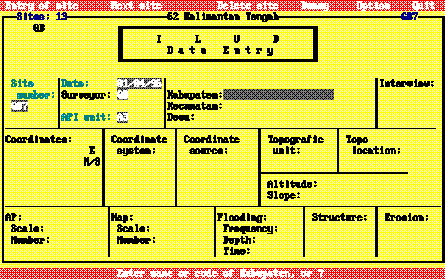
Fig.8: Sample Screen for Data Entry to GIS (Digitization)
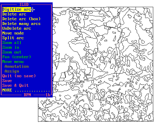
Fig.9: Sample Screen for Data Retrieval
Introduction of this easy, user-friendly interface was a 'must' to establish a GIS in a large organization with decentralized structure, but with the request for a nationwide unique technical approach. In LREPP-II/B there was no alternative to the full software ('user interface') environment, the 'application development'.
To give an idea of the magnitude of the user interface software: Some 800 pages (1462 kB) of source codes for the GIS (sml files), some 500 pages (916 kB) of source codes for the DBMS (prg files), some 50 pages (78 kB) of other source codes (Pascal, DOS batches, Lotus macros), and 198 kB auxiliary data files have been developed.
Programs have been distributed only in compiled form (Clipper compiler for DBMS to generate exe file, pseudo ArcInfo compiler to generate cml/cmx files) for three reasons:
The entire software fits compressed on two floppy disks (one for GIS, one for DBMS). All programs are bi-lingual (English and Indonesian).
The success showed that all data which have been compiled through ILUD software interfaces are structurally ‘clean’, follow the same data coding, can be exchanged easily and fulfill data quality standards.
Following modules have been developed:
Tab.2: ILUD Modules
| ILUDEntr | DBMS | Entry of field data | |
| ILUDProc | DBMS | Processing of field data and transfer to GIS | |
| ILUDList | DBMS | Retrieval of field data, transfer of points to GIS | |
| ILUDUtil | DBMS | Utility set for DBMS data
| |
| ILUDArc | GIS | Digitizing of arcs (for lines and polygons) | |
| ILUDLab | GIS | Labeling of polygons and link to DBMS | |
| ILUDPoi | GIS | Digitizing of points | |
| ILUDCon | GIS | Conversion between different projections | |
| ILUDPlt | GIS | Plotting | |
| ILUDUtl | GIS | Utility set for GIS data | |
| ILUDAdm | GIS | Compilation of maps on administrative basis | |
| ILUDMon | GIS | Monitoring of land use changes | |
| ILUDR2v | GIS | Conversion of raster images to vector GIS | |
| ILUDImp | GIS | Import of points to GIS | |
| ILUDExp | GIS | Export of points from GIS to DBMS | |
| ILUDSed | GIS | Assessment of land availability | |
| ILUDKes | GIS | Land suitability assessment | |
| ILUDUnt | GIS | Compilation of spatial land use management plans |
They include in-built error trapping routines, which guarantee that the data fulfill necessary quality standards for formal data integrity.
3.4 Standard Output
It is important that data which have been collected and entered in a database, can be retrieved and transferred (or displayed or printed) in an easy and particularly standardized way !
Only when an information system can supply the data in the way as requested by the users of the data is the system justified. If, for example, the user wants to have a look at the hardcopy map for orientation only, he can be supplied with a hardcopy map. If the user wants to further process the data digitally, he can be supplied with the GIS digital data (coverage).
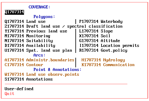
There are two types of ‘output’ from a geographical databank as ILUD:
These ‘products’ have been made uniform and standardized.
Digital data with all its codes, structures, files follow the given (and documented) syntax and standards.
The project has a standard layout for hardcopy map production at the scales of 1:25,000, 1:50,000 and 1:100,000 at DIN A0 size, following the national map grid index.
Digital outputs of the project’s mapping are various graphics formats such as BMP, PCX or PLT files, or the original data in their coverage, xBase, GIS file formats.
Beside the 'standard' output maps of land use and land use plans, the system is capable to respond on special requests, such as:
While the previous components have been fully established and implemented for ILUD in course of LREPP-II/B, the following two components have only been started with their implementation:
3.5 Marketing strategy and Public Relation Work, Distribution Policy:
‘Information not used is information better not collected !’
To enable potential clients to make use of these maps and to integrate this information in their planning efforts, they have to be aware of the data and all facilities.
Various activities, intentions and plans for such ‘public relation’ work have been set up in LREPP-II/B.
The most global PR system is the Internet. A homepage (http://www. oocities.com/Tokyo/2439/) has been set up, which shows the data progress achieved, the facilities of the system, the technical specs and options to contact the agency for data and technical advise.
Data requests can be made through the Internet. After having been cleared by BPN officials, data can be transmitted on disk or through the Internet.
A policy of distributing and/or selling data is still to be defined. Cost assessments to define a ‘service fee’ have been calculated.
3.6 Contribution to Spatial Planning
This is seen as the ultimate goal, to make all the efforts of land use data collection, processing and presentation meaningful and as a contribution to land use planning towards a sustainable, efficient and ecological use of land in Indonesia.
There are two envisaged data flows:
4 What is ILUD for ?
Spatial Planning with ILUD
BPN has the task to execute land use planning through the issue of location permits, including their control and monitoring. ILUD includes these activities, to support BPN in its task. In such an application system with the task of improving land use through land use survey and monitoring tools, the target is to have a complete decision tool for management support for "spatial land use management planning".
Fig.10: Concept of Land Allocation Assignment
4.1 Availability of Land under the Actual Land Use and Legislation
Land can only be allocated to new land use pattern, if the actual land use under the land use legislation permits it. Land can not be allocated to new land uses, where steep slopes or shallow soils can not maintain a sustainable use, where land would be taken out of the main food production cycle (paddy rice land), along rivers in 50 m corridors, in already built-up areas, or in already assigned land. Most of these regulations are defined as presidential degrees.
ILUD can compile and produce maps showing these areas (overlay of land use, slope, altitude, hydrology, already allocated land).
4.2 Land Evaluation
The physical land evaluation basically follows the concept of FAO’s framework for land evaluation, with the definition of land utilization types, land characteristics, land qualities, and suitability ratings of S1-N2.
As data sources, resources maps with information about slope, altitude, drainage, erosion status, texture, drainage are linked and matched with the requirements of land use types (land utilization types, here called 'sectors'). At the present 20 of those types are defined with their requirements:
Tab.2: Considered Land Utilization Types
For user-friendly application, high performance and standardized output, a module to execute land evaluation, i.e. to assess the suitability in terms of suitable and unsuitable classes (S1, S2, S3, N1, N2) for specific land utilization types has been developed (module ILUDKes). It overlays slope, soils, and altitude maps, evaluates the suitability for the selected land use type for each land characteristic, and summarizes based on the limiting factor approach.
4.3 Government Policy for Development
These maps are ‘input maps’ to the spatial land use management procedure. They have been defined by planning councils at various levels, partly based on the findings of the previously explained two maps (land availability map and land suitability maps).
4.4 Land Allocation ('Spatial Land Use Management Plan')
With the two assessments of land availability and land suitability and with the input of Government policy, where land use should be developed according to the Development Plans of Indonesia (at national, provincial, or district level), land can be allocated.
The execution of this double overlay is done with module ILUDUnt.
Example: A housing complex can only be permitted, if the suitability is good (not steep slope), the availability is given (not replacing rice land), and where the development policy does not declare other priorities.
4.5 Monitoring of Land Use Changes and Location Permits
One of the most important future activities might be the monitoring, in particularly of ‘permits, the endproduct of the process of spatial planning activities ... the controlling tool of spatial planning’ (Ir. Soni Harsono, ibd).
Technically, monitoring is understood at two stages: At the first step, it is the detection of land use changes, i.e. taking two land use maps of different years and compare them. (Overlay of two maps to define units which are not equal).
At the next level - and more important in terms of land use control - is the integration of issued location permits to the land use change detection. There are following units resulting from such an overlay:
5. What’s next in ILUD ?
Achievements during LREPP-II/B and Outlook on Future Development
Fig.11 below shows in the years 1993-1997 the main methodological achievements of LREPP-II/B on ILUD (databank setup) activities, to mention the:
and the start of activities such as:
Fig. 11: ILUD Development
In future, as shown for the years 1997-2000, methodology development will have to concentrate on:
Beside these ‘new’ main activities, improvements shall still be done in the established fields:
etc.
Maintenance of data and training will be a permanent, important activity of the information system.
Following personell structure is proposed to execute these tasks and to operate the information system:
Fig. 12: ILUD Staff Hierarchy
(image)
6. Closing Remark
It has been shown, that ILUD is more than just a few Arc/Info coverages with some field data in an attribute table: It is an entire application system of mapping land use and preparing spatial land use management plans. Thus, the application is the most important characteristic of the system: To be easily applied by different users of different skill, and to come up with the same type of result with the same standards and of the same quality.
The second characteristic, where ILUD is more than a few Arc/Info coverages, is the targetting of all activities and definitions towards the main output of supporting decision makers in different institutions with proper information about land use in the past, at the present, and in modelled future situations.
But data gathering and plotting of a land use map can not be the final goal of a land use planning support system - and of ILUD.
Technology becomes only one step in the process of defining, implementing and monitoring land use plans. Like in many other places, emphasis on the technology itself has to be reduced, more emphasis has to be given to the actual content of data and the decisions based on these data.
By making ILUD a user-friendly, robust, direct, straight-forward applicable system, this is our contribution to shifting the emphasis away from over-stressing technology, and towards an application tool for land use planning. Thus, ILUD can contribute to land use planning with supporting adequate, reliable, and up-to-date data, that it can be user-friendly, and is affordable.
Project LREPP-II/B has given a perfect environment,
the information system, as it was necessary in this ‘new digital era’ of information technology, where information - including processing of, access to and distribution of information - plays an increasingly important role for the decision making progress at land use planning. While LREPP-II/B is coming to its end, the products of the project: The ILUD methodology, system, standards will give all the strength to BPN / PGT and can hopefully contribute to the further development of Indonesia.