- (Legal) Land Availability
- (Physical) Land Suitability
- Government Policy for Development
- Land Allocation
- Graphical Summary of Framework
-
Availability of Land under the Actual Land Use and Legislation:
- Permanent production forest
- Limited production forest
- Converted production forest
- Rice paddy
- Maize
- Peanut
- Soybean
- Banana
- Oil palm
- Rubber
- Cacao
- Coffee
- Tea
- Animal husbandry
- Fishery, aquaculture
- Urban settlement
- Rural settlement
- Industry
- Tourism
- Mining
- Permanent production forest
- Limited production forest
- Converted production forest
- Rice paddy
- Maize
- Peanut
- Soybean
- Banana
- Oil palm
- Rubber
- Cacao
- Coffee
- Tea
- Animal husbandry
- Fishery, aquaculture
- Urban settlement
- Rural settlement
- Industry
- Tourism
- Mining
Land can only be allocated to new land use pattern, if the actual land use under the land use legislation permits it. In Indonesia, land can not be allocated to new land uses, where steep slopes or shallow soils can not maintain a sustainable use, where land would be taken out of the main food production cycle (paddy rice land), along rivers in 50 m corridors, in already built-up areas, or in already assigned land. Most of these regulations are defined as presidential degrees.
The processing (overlay of land use, slope, altitude, hydrology, already
allocated land) is done in ILUD with module ILUDSed.
Sample map from West Java -
Legend of sample map
Back to top
The physical land evaluation basically follows the concept of FAO's framework
for land evaluation, with the definition of land utilization types, land
characteristics, land qualities, suitability ratings of S1-N2.
As data sources, resources maps with information about slope, altitude,
drainage, erosion status, texture, drainage are linked and matched with
the requirements of land use types (land utilization types, here called
'sectors'). At the present 20 of those types are defined with their
requirements:
Considered Land Utilization Types:
As soon as more data types become available and need arises for more
detailed assessment, they will be incorporated.
For user-friendly application, high performance and standardized output, a
module to execute land evaluation, i.e. to assess the suitability in terms
of suitable and unsuitable classes (S1, S2, S3, N1, N2) for specific land
utilization types has been developed (module ILUDKes). It overlays slope,
soils, and altitude maps, evaluates the suitability for the selected land
use type for each land characteristic, and summarizes based on the limiting
factor approach.
The processing (overlay of land use, slope, altitude, soil) is done in
ILUD with module ILUDKes.
Sample map for Tea, from West Java -
Legend of sample map
Back to top
These maps are input maps to the spatial land use management procedure.
They have been defined by planning councils at various levels, not by BPN,
partly based on the findings of the land availability map and land
suitability maps.
Sample map from West Java -
Legend of sample map
Back to top
With the two assessments of land availability and land suitability
and with the third input of Government policy, where land use should be
developed according to the 5-year Development Plans of Indonesia (at
national, provincial, or district level), land can be allocated.
Example: A housing complex can only be permitted, if the suitability
is good (not steep slope), the availability is given (not replacing rice
land), and where the development policy does not declare other priorities.
Considered Land Utilization Types:
The processing (overlay of land availability, land suitability, and
development policy) is done in ILUD with module ILUDUnt.
Sample map for urban extension, from West Java -
Legend of sample map
Land Evaluation:
Government Policy for Development:
Land Allocation ('Spatial Land Use Management Plan')
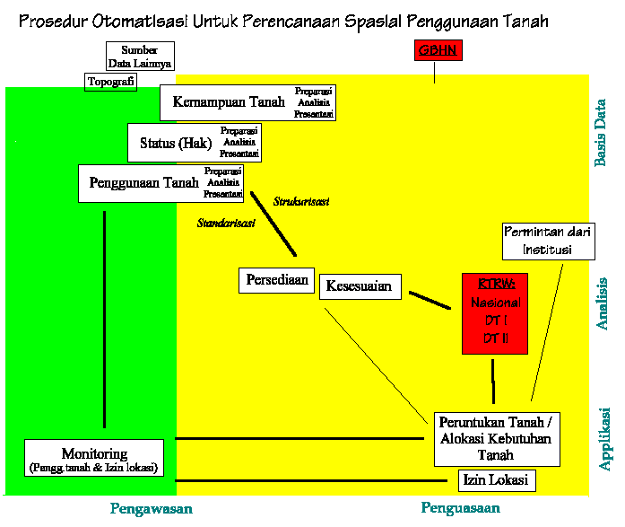
Same chart, but including operational procedures
Back to Homepage
.visit