
Kaeng Krachan National Park was established in 1981, the 28th National Park in Thailand. It is the largest national park in Thailand, with 1,821,875 rai (2,915 square kilometers) of forest in the watersheds of the Phetchaburi and Pranburi rivers. It includes portions of Amphur Nong Ya Plong, Amphur Kaeng Krachan, and Amphur Tha Yang in Phetchaburi Province and of Amphur Hua Hin in Prachuab Khiri Khan Province.
The Kaeng Krachan area includes a reservoir lake, beautifual scenery, waterfalls, caves, mountains.It is almost entirely covered with evergreen forest, which supports ecologically, economically and scientifically valuable plants and animals, including many wild elephants. The park is an excellent place for recreation and education, and it is carefully protected in accordance with the wishes of His Majesty King Bhumipol. It is an important part of Thailands national heritage.
History
Kaeng Krachan dam, at the middle of the eastern border of the National Park, was the first earth dam ever constructed in Thailand, more than 30 years ago. Its reservoir is fed by a forested watershed which extends to the Tenasserim Crest, the mountain range dividing the watersheds of the Gulf of Siam and the Andaman Sea. His Majesty King Bhumipol Adulyadej has visited the site many times, both before and after the construction of the dam. He has always been very concerned about the conservation of this watershed area, as indicated in his speech of October 29,1979 : In Phetchaburi watershed forest, the officers must guard against deforestation, illegal logging or cultivation, because they cause drought.
The National Park was designated on June 12,1981: its original borders encompassed 1.5 million rai. On April 20,1983, Thalemg Thamrongnawasawad, Permanent Secretary of the Ministry of Agriculture and Cooperatives, presided over the official opening ceremony. On December 27,1984, the park area was extended, as proposed by the Hua Hin Environmental Conservation Group, to cover the boundary between Phetchaburi and Prachuab Khinkhan Provinces, bringing the total area to over 1.8 million rai.
Geography
Kaeng Krachan is located on the eastern slope of the Tenasserim Mountain Range at the border of Burma (Myanmar). It occupies the western half of Phetchaburi Province (Amphur Kaeng Krachan and Amphur Nong Ya Plong) and a portion of northern Prachuab Khiri Khan Province (Amphur Hua Hin).
The park is compossed of two major watersheds. About half of the area drains to the Phetchaburi River, which flows to Kaeng Krachan dam at the eastern edge of the park and then down through farmland to the provincial capital of Phetchaburi. The southern half of the park drains to the Pranburi River, which flows south to the Pranburi dam and then on to the town of Pranburi in Prachuab Khiri Khan Province. Because of abundant rainfall and undisturbed forest cover in these watersheds, the streams, waterfalls and rivers of Kaeng Krachan flow year-round.
The nearest cities to the park are Phetchaburi Town, the market town of Tha Yang, and the resort cities of Cha-Am and Hun Hin. The park is located about 240 kilometers from Bangkok. Only two roads are maintained within the park. One leads to the Pala-u Waterfall in the southern part of the park; the other enters the forest 20 kilometers away from headquarters, and continues for 35 kilometers westaard into the heart of the park near Khao Panoen Thung.
The steep terrain of Kaeng Krachan makes it very difficult to travel within the forest. The rivers have cut deep valleys through sandstone to the underlying granite. Some limestone deposits occur, primarily in the Pranburi river basin. Khao Panoen Thung, at 1,207 meters, is the tallest peak entirely within the park. It is a dome of granite resistant to the erosion which has removed the sandstone around it. The highest point in the park is a peak along the Burmese border, at 1500 meters.
Climate
![]()
![]()
Humidity remains high throughout the year, with heavy rain during the rainy season and cool weather for much of the year. The steep forested areas of the park are even more humid than the young forest and cleared lands in the lower elevations; some days it is clear and warm at headquarters, but it may be raining very hard in the forest 20 kilometers away. Near headquarters, annual rainfall averages 1,100 milimeters (although within the forest, it is probably much more). The wettest month is October, when rains can be nearly continuous and almost one-quarter of the annual rainfall may arrive. The driest month in an average year is January. The coldest months are December and January; the hottest are March and April. Temperatures in the area range from 10 to 40 Degree Celsius , and may get colder on the mountaintops within the forest.
Botany
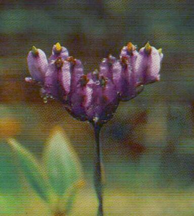
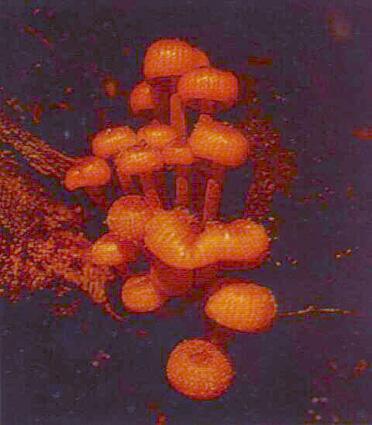


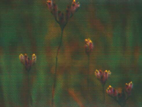
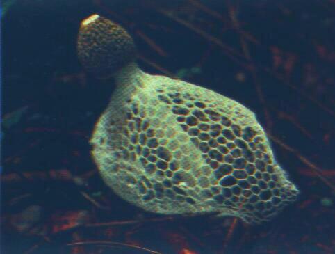
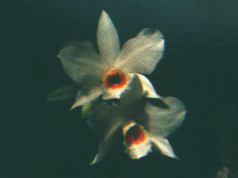
Most of the park is covered in deep, steep forest, Over three-quarters of the area has slopes greater than 30%, 85% of the terrain is evergreen rainforest; another 10% is mixed deciduous forest. The forest is rich and complex, with hanging lianas, aerial ferns and orchids, and an abundance of fruiting trees and vines. The forest of Kaeng Krachan is unusually diverse because of its location at the juncture of continental Asia and the Malaysian Peninsula. Continental species such as oaks, chestnuts, and maples are found here, as are peninsular palms and fruiting trees. Some of the valuable trees of Kaeng Krachan include makhamong (Afzelia), thakhian (Hopea), jantana, yang (Dipterocarpus), tabaek (Lagerstroemia), pradoo (Pterocarpus), krisna (Aquilaria), and many more.
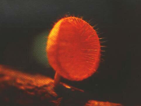
Wildlife


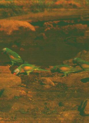
Like the plant community, the animals of Kaeng Krachan represent both Asiatic and Jalaysian species. Over 400 species of birds are known to occur within the Parks boundaries, and 57 mammais. Larger mammals include elephant, gaur, sambar, banteng, serow, bear, tiger, leopard, both common and Feas barking deer, tapir, white-handed gibbon, dusky and banded langurs (leaf monkeys), wild dog, otter, and wild pig. Four white elephants captured in this area have been given to His Majesty the King. Among the birds recorded in the park are six species of hombills, red junglefowl, both Kalij and grey peacock-pheasants, woolly-necked stork, black eagle, and many species of songbirds, woodpeckers, and other forest birds. The ratchet-tailed treepie, first seen here by members of the Bangkok Bird Club (Bird Conservation Society of Thailand) on an outing in 1991, has not been recorded anywhere else in Thailand.
Tourist Attractions
Visitors to the park may enjoy relaxing by the lake at headquarters, touring Pala-u Waterfall in Prachuab Khiri Khan province, or taking a boat tour of the lake and the lower Phetchaburi, River. For a more rugged experience of the park, visitors may request permission to travel up the Khao Panoen Thung Road or to arrange hiles of one or more days. Visitors inside the park encounter evergreen forest, clear mountain streams, and wildlife. Visitors who wish to tour the forest along the Khao Panoen Thung Road or to hike the trails within the forest must request a permit at the visitor center located at headquarters. In general, guide service is required for any forest travel away from the Khao Panoen Thung Road. Trekking and hiking are not possible during the rainy season, when the trails are treacherously slippery and the road may become impassable.
In Phetchaburi
Province...

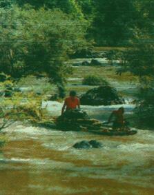
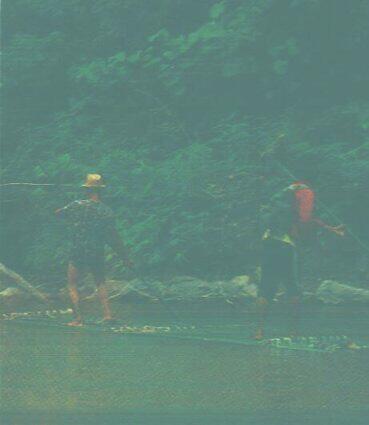
Kaeng Krachan Reservoir. The reservoir covers an area of 46.5 square kilometers and has a capacity of 710 million cubic meters. It was created by the construction of the earth dam which blocked the Phetchaburi River. The largest island in the lake is approximately 75 square kilometer. Many tourists enjoy hiring a boat for sightseeing around the lake. Observing village life from the water, and visiting the islands.
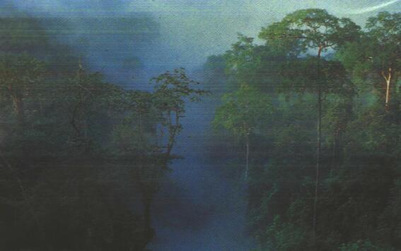
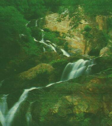
Khao Panoen Thung/Nam Tok Thorthip Road : This 35 kilometer road was constructed in 1988 especially for tourism. It begins at the Khao Sam Yod ranger station. 20 kilometers away from headquarters. The road runs through primary forest and offers spectacular views of mountains and wildlife, an ocean of mountain ranges covered in deep-green forest all year round, and, early in the morning, the sea of fog. Day hikers in any season may walk independently along the road to observe primates, birds, and other wildlife as well as scenic views. Overnight camping facilities are available at Kilometer 15, 27 and 30.
Phanoen Thung Mountain : At 1,207 meters above sea level, this is the second highest peak in the mational park. On the mountain top, grassland and evergreen forest make a good camping spot, with cool temperatures year-round. The view from the top includes a beautiful panorama of green forest, mountains, sunrises and sunsets, and the sea of fog. Formed when mists fill the valleys in the early morning. Mineral licks in the grassland attract large mammals. A 6-kilometer trail begins at kilometer 27 for a strenuous hike.
Thorthip Waterfall :
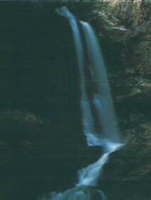
 At this nine-level waterfall deep in the forest, water flows all year round.
The waterfall is reached by a steep 4-kilometer trail from the end of the
Nam Tok Thorthip Road, 35 kilometers from the edge of the park and 56 kilometers
from headquarters. A campground has been built nearly at the confluence
with the Phetchaburi River.
At this nine-level waterfall deep in the forest, water flows all year round.
The waterfall is reached by a steep 4-kilometer trail from the end of the
Nam Tok Thorthip Road, 35 kilometers from the edge of the park and 56 kilometers
from headquarters. A campground has been built nearly at the confluence
with the Phetchaburi River.
Thanthip and Hinlad Waterfalls: These two waterfalls cascade through deep forest all year long. They are located on a tributary of the Phetchaburi River about 5 kilometers upstream of the Thorthip confluence, and may be visited as part of a three-or four-day loop trek along with Thorthip Waterfall.
Pranburi Waterfall: This three-level waterfall is located on the upper Pranburi River, in the valley just south of the steep hill-climb at Kilometer 18-23 on the Khao Panoen Thung Road. It can be visited on a one-day hike.
Mae Saliang Waterfall: This three-level waterfall is located 5 kilometers west of the roadside campground at Kilometer 27. It is recommended for day-hiking and camping.
Phetchaburi and Bang Gloy Rivers:
 Beautiful scenery, wildlife, and rich forest along these rivers can best
be enjoyed while travelling down the river-a journey of about five to seven
days. This trip is possible only by special arrangement and permission
of the superintendent.
Beautiful scenery, wildlife, and rich forest along these rivers can best
be enjoyed while travelling down the river-a journey of about five to seven
days. This trip is possible only by special arrangement and permission
of the superintendent.
Pakarang Mountain (Lan Hanuman):
 Many macaques, langurs (leaf monkeys) and gibbons inhabit the forest in
this area, and rock formations on the mountain are said to resemble coral
reefs. This mountain can be reached on a day hike of about 12 kilometers
round trip, travelling through former village area now used extensively
by wildlife. It is possible to camp overnight at the top. Nearby is Bat
Cave, which can be included in a hiking tours.
Many macaques, langurs (leaf monkeys) and gibbons inhabit the forest in
this area, and rock formations on the mountain are said to resemble coral
reefs. This mountain can be reached on a day hike of about 12 kilometers
round trip, travelling through former village area now used extensively
by wildlife. It is possible to camp overnight at the top. Nearby is Bat
Cave, which can be included in a hiking tours.
In Amphur Nong Ya Plong....
Huay Dungla Waterfall: This waterfall with three levels, is located in the far northern part of the national park, in Amphur Nong Ya Plong, 8 kilometers from the remote guard station at Khao Phu Plu.
Hot Spring: A natural hot mineral spring with water of about 55° C, is located near the remote guard station in the northern part of the park, in Amphur Nong Ya Plong.
In Prachuab Khiri Khan Province......
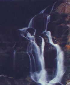
Pala-u Waterfall: This popular waterfall has sixteen levels, and is located in Amphur Hua Hin, in the southern part of the national park. Water flows throughout the year. Two other waterfalls, Huai Palao Falls and Chonlanath Falls, are located near the ranger station at Pala-u. Chonlanath is the tallest waterfall in Kaeng Krachan National Park.
Wiman Cave:
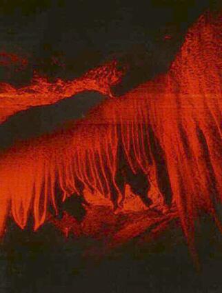
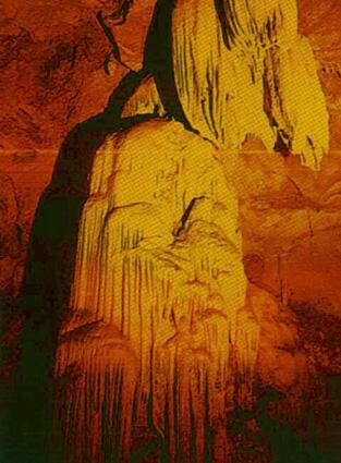 Beautiful
stalactites and stalagmites are found in this cool cave. Evidence of ancient
inhabitants-ceramics and stone exes-has been found in this cave near the
Huay Kangpla waterall.
Beautiful
stalactites and stalagmites are found in this cool cave. Evidence of ancient
inhabitants-ceramics and stone exes-has been found in this cave near the
Huay Kangpla waterall.
Transportation
By private vehicle.....To Park Headquarters: 20 kilometers south of Phetchaburi town, at Amphur Tha Yang, turn left at the intersection and follow signs to the park (38 kilometers). The road (Highway 3175) crosses the river near Phetchaburi Dam and crosses rural land to Amphur Kaeng Krachan. Pass through a guardpost, and take the second left across a bridge over the river. Follow the road up the face of the Kaeng Krachan dam. At the top of the dam, turn left and continue 2.5 kilometers along the lakeshore to headquarters.
To the Khao Panoen Thung Road.... From
headquarters, drive south and west along the lake (away from the dam) 10
km to the second left-hand turn, at the Army Training Center. Follow this
road 9 km to a T and turn right. The ranger station at Khao Sam Yod is
1 km west of this T. Please stop to show the ranger your permit. The
Khao Panoen Thung Road continues 35 km from here to its dead-end.
Up Time 05:30 - 09:30 and 13:30 - 14:00
Down Time 11:00 - 12:30 and 16:30 - 18:00
To Pala-u Waterfall..... South of Tha Yang and Cha-Am, at Hua Hin, turn right (west) on Highway 3219 to Pala-u waterfall and follow signs to the ranger station (62 kilometers). From the ranger station, continue on 4 kilometers to the waterfall. The road from the ranger station is presently being improved; for now, expect to ford Pala-u Creek in two places and climb a steep grade.
Tourist Services and Facilities (arranged at Visitor Center)
Camping: Campgrounds are available at headquarters, and along the Khao Panoen Thung Road at Kilometer 15, 27, and 30
Boat trips: Longtail boats provide sightseeing tours around the lake with luncheon, dinner, or other optical amenities.
Overnight visits: Park accomodations, with water, electricity and 24-hour security, are available for individuals and grups of up to 80 in bungalows or 150 camping. Facilities and services for large groups, including meeting rooms, audio-visual equipment, catering and other services, may be arranged with the Visitor Center manager.
Guide service: Park guides are available, depending on their regular workload, for day and overnight trips. In the rainy season, trekking is generally not allowed due to the hazards of falling trees and slippery trails.
Transportation: Visitor center staff can help arrange vehicle rental for day and overnight trips into the park. Experienced drivers with private vehicles which are sturdy and equipped with mufflers may be permitted to drive in the park at the discretion of park management. Motorcycles and loud vehicles are not allowed.
Reservations and further information : Please contact:
Interpretation and Recreation Sub-division
National Park Division
Natural Resources Conservation Office
Royal Forest Department Chatuchak, Bangkok 10900
Tel. : 579-4842, 579-0529, 579-5269
Or contact the park directly:
Kaeng Krachan National Park
Amphur Kaeng Krachan
Phetchaburi 76170
How to get there
From Bangkok to Phetchaburi is 115 kilometers. There are many roads which
enter the park. There is an asphalt road which goes to park headquarters,
there are several other roads which are commonly driven:
1. 6 Kilometers north of Phetchaburi
town there is a road which leads 52 kilometers into the park.
2. From Phetchaburi town, drive 20
kilometers towards Amphur Tha Yang. Take a left and drive 38 kilometers
to the park. The general public generally uses this road.
3. From Phetchaburi, drive through Amphur Tha Yang, Cha-Am to
Ahphur Hua Hin. Here turn left and drive 62 kilometers into the park.
* * * * * * * * * * * * * * * * * * * * * * * * * * * * * * * * *
|
|
|