|
|
|
|
|
|
|
|
|
|
|
|
|
|
|
|
|
|
|
|
|
|
|
|
|
|
|
|
|
|
|
|
|
|
|
|
|
|
|
<HOME> |
|
|
|
|
|
|
|
|
|
|
|
|
|
|
|
|
|
|
|
|
|
|
|
|
|
|
|
|
|
|
State of Kerala, the Present
Day
|
|
|
|
|
|
|
|
|
|
|
|
|
|
|
|
|
|
|
|
|
|
|
|
|
|
|
|
|
|
|
|
|
|
|
|
|
|
|
|
|
|
|
|
|
|
|
|
|
|
|
|
|
|
|
|
|
|
|
|
|
|
|
|
|
|
|
|
|
|
|
|
|
|
|
|
|
|
|
|
|
|
|
|
|
|
|
|
|
|
|
|
|
|
|
|
|
|
|
|
|
|
|
|
|
|
|
|
|
|
|
|
|
|
|
|
|
|
|
|
|
|
|
|
|
|
|
|
|
|
|
|
|
AREA : 2,192 sq. k.m------------------------
POPULATION : 2,938,583------------------
|
|
|
|
|
|
|
|
|
|
|
|
|
|
|
|
|
|
|
|
|
|
|
|
|
|
|
|
|
|
|
|
|
|
|
|
Thiruvananthapuram,
lying on the southwest coast of India,is the capital of the state of Kerala.
The city extends from latitude 8 °29' N to longitude 76°59' E. The
place is well connected to most of the other major cities of India through
rail, road and air network. |
|
|
|
|
|
|
|
|
|
|
|
|
|
|
|
|
|
|
|
Thiruvananthapuram
|
|
|
|
|
|
|
|
|
|
|
|
|
|
|
|
|
|
|
|
|
|
|
|
|
|
|
|
|
|
|
|
|
|
|
|
|
|
|
|
|
|
|
|
|
|
|
|
|
|
|
|
|
The climate of Thiruvananthapuram
is tropical, as it is in the other parts of Kerala. It has got a very pleasant
weather round the year. The average maximum temperature can go up to 36.2°c
in the summer and to a minimum of 18°c in the winter. Monsoon comes
in the month of May and reamains there until November. |
|
|
|
|
|
|
|
|
|
|
|
|
|
|
|
|
|
|
|
|
|
|
|
|
|
|
The city derives its
name from the deity at the Sree Anantha Padmanabhaswami Temple, one of the
major landmarks of the place. The name of the city is derived from the words
Thiru-Anantha-Puram, meaning the town of Anantha. Although no records of
the antiquity of the temple really exists, the temple nevertheless is believed
to be several thousands years old.
|
|
|
|
|
|
|
|
|
|
|
|
|
|
|
|
|
|
|
|
|
|
TOP |
|
|
|
|
|
|
|
|
|
|
|
|
|
|
|
|
|
|
|
|
|
|
|
|
|
|
|
|
|
|
|
|
|
|
|
|
|
|
|
|
|
|
|
|
|
|
|
|
|
|
|
|
|
|
|
|
|
|
|
|
|
|
|
|
| AREA
: 2,579 sq. km.------------------------
POPULATION : 2,398,285 --------------- |
|
|
|
|
|
|
|
|
|
|
|
|
|
|
|
|
|
|
|
|
|
|
|
|
|
|
|
|
|
|
|
|
|
|
Kollam is
encircled by Alappuzha in the north, Pathanamthitta in the northeast, Tamilnadu
in the east, Thiruvananthapuram in the south, and the Arabian Sea in the
west. It extends latitude 9°28' and longitude 76°17' north. |
|
|
|
|
|
|
|
|
|
|
|
|
|
|
|
|
|
|
|
Kollam
|
|
|
|
|
|
|
|
|
|
|
|
|
|
|
|
|
|
|
|
|
|
|
|
|
|
|
|
|
|
|
|
|
|
|
|
|
|
|
|
|
|
|
|
|
|
|
|
|
|
|
|
|
The climate is of tropical
humid type with an oppressive summer and plenty of seasonal rainfall. The
summer, lasting from March to May, is followed by the southwest monsoon
from June to September. The northeast monsoon occurs from October to November.
The rest of the year is generally dry.
|
|
|
|
|
|
|
|
|
|
|
|
|
|
|
|
|
|
|
|
|
TOP |
|
|
|
|
|
|
|
|
|
|
|
|
|
|
|
|
|
|
|
|
|
|
|
|
|
|
|
|
|
|
|
|
|
|
|
|
|
|
|
|
|
|
|
|
|
|
|
|
|
|
|
|
|
|
|
|
|
|
|
|
|
AREA : 2,642 sq.km.------------------------
POPULATION : 1,231,577 |
|
|
|
|
|
|
|
|
|
|
|
|
|
|
|
|
|
|
|
|
|
|
|
|
|
|
|
The distirict
has more or less the same climate condition as prevalent elsewhere in the
state. The dry season is from December to February and the hot season is
from March to May. The south west monsoon is from June to September and
the north west monsoon is from October to November which provide fairly
good rain. |
|
|
|
|
|
|
|
|
|
|
|
|
|
|
|
|
|
|
Pathanamthitta
|
|
|
|
|
|
|
|
|
|
|
|
|
|
|
|
|
|
|
|
|
|
|
|
|
|
|
|
|
|
|
|
|
|
|
|
|
|
|
|
|
|
|
|
|
|
|
|
|
Pathanmthitta is frequented
by visitors from India and abroad for its water fiestas, religious shrines
and its cultural training centre. More than 50% of the total area of this
land is covered by forests, making for a scenic landscape. |
|
|
|
|
|
|
|
|
|
|
|
|
|
|
|
|
|
|
|
|
TOP |
|
|
|
|
|
|
|
|
|
|
|
|
|
|
|
|
|
|
|
|
|
|
|
|
|
|
|
|
|
|
|
|
|
|
|
|
|
|
|
|
|
|
|
|
|
|
|
|
|
|
|
|
|
|
|
|
|
|
|
|
|
| AREA
: 1,414 sq. km.--------------------------
POPULATION : 2,105,349 |
|
|
|
|
|
|
|
|
|
|
|
|
|
|
|
|
|
|
|
|
|
|
|
|
|
|
|
|
Alappuzha
is one of the exotic backwater sites of the state of Kerala. Washed by the
Arabian Sea, interlocked by a number of canals and bridges, this tiny market
place is also famous for Nehru Trophy boat race held every year. Alappuzha
attracts tourists not only by its natural beauty but also through its coir
products that are of a superior quality. |
|
|
|
|
|
|
|
|
|
|
|
|
|
|
|
|
|
Alappuzha
|
|
|
|
|
|
|
|
|
|
|
|
|
|
|
|
|
|
|
|
|
|
|
|
|
|
|
|
|
|
|
|
|
|
|
|
|
|
|
|
|
|
|
|
|
|
|
|
|
The climate of this
small town is temperate and humid in general and relatively more pleasant
in the winter season. The months from August - Septemeber and February -
March are ideal for a visit to this place. |
|
|
|
|
|
|
|
|
|
|
|
|
|
|
|
|
|
|
|
|
|
|
|
|
|
|
Before the Dutch took
over this place, the Portuguese were the predominant rulers of this place.
Later Maharaja Marthandavarma came into power and he gave ample importance
to the developmental works of the place. Slowly it became a very busy commercial
place attracting merchants from all over.
Alappuzha is also known as the 'Venice of the East'. |
|
|
|
|
|
|
|
|
|
|
|
|
|
|
|
|
|
|
|
|
TOP |
|
|
|
|
|
|
|
|
|
|
|
|
|
|
|
|
|
|
|
|
|
|
|
|
|
|
|
|
|
|
|
|
|
|
|
|
|
|
|
|
|
|
|
|
|
|
|
|
|
|
|
|
|
|
|
|
|
|
|
|
|
AREA : 2,204 sq.
km. ----------------------- POPULATION : 1,828,271 |
|
|
|
|
|
|
|
|
|
|
|
|
|
|
|
|
|
|
|
|
|
|
|
|
|
|
|
The best
time to visit this place is during the months of August and March when the
tropical climate is not so hot and humid. This makes travelling comfortable.
Light winter sweaters and a shawl would be enough to meet the chill here.
|
|
|
|
|
|
|
|
|
|
|
|
|
|
|
|
|
|
Kottayam
|
|
|
|
|
|
|
|
|
|
|
|
|
|
|
|
|
|
|
|
|
|
|
|
|
|
|
|
|
|
|
|
|
|
|
|
|
|
|
|
|
|
|
|
|
|
|
|
|
The word Kottayam is
a composition of the words Kotta (meaning fort) and Akkam (meaning inside).
Kottayam is one of the exotic backwaters sites attracting tourists throughout
the year. Being a mountainous region with scenic landscapes, backwaters,
bird sanctuaries, temples and churches make this a place of tourist attraction.
|
|
|
|
|
|
|
|
|
|
|
|
|
|
|
|
|
|
|
|
|
|
TOP |
|
|
|
|
|
|
|
|
|
|
|
|
|
|
|
|
|
|
|
|
|
|
|
|
|
|
|
|
|
|
|
|
|
|
|
|
|
|
|
|
|
|
|
|
|
|
|
|
|
|
|
|
|
|
|
|
|
|
|
|
|
|
|
|
|
|
|
AREA : 5,019 sq.
km.--------- -POPULATION : 1,128,605 |
|
|
|
|
|
|
|
|
|
|
|
|
|
|
|
|
|
|
|
|
|
|
|
|
|
|
|
|
The climate
in the district undergoes a sudden variation as we go from West to East.
The western parts of the distirct comprising midland area experiences moderate
climate, temperture varying between 21degree C to 27degreeC with minimum
seasonal variation. |
|
|
|
|
|
|
|
|
|
|
|
|
|
|
|
|
|
Idukki
|
|
|
|
|
|
|
|
|
|
|
|
|
|
|
|
|
|
|
|
|
|
|
|
|
|
|
|
|
|
|
|
|
|
|
|
|
|
|
|
|
|
|
|
|
|
|
|
|
As a tourist destination,
Idukki is incomparable. It provides forests, wildlife sanctuaries, hill
stations, spice tours, elephant rides and some of the most spectacular landscapes
any where in the world. |
|
|
|
|
|
|
|
|
|
|
|
|
|
|
|
|
|
|
|
|
|
|
|
|
|
|
|
The name Idukki is
derived from the local word 'Idukku' which literally means narrow gorge.
This could be true for narrow steep sided valleys are not a strange phenomenon
in this hilly district flanked by the Western Ghats. |
|
|
|
|
|
|
|
|
|
|
|
|
|
|
|
|
|
|
|
|
|
TOP |
|
|
|
|
|
|
|
|
|
|
|
|
|
|
|
|
|
|
|
|
|
|
|
|
|
|
|
|
|
|
|
|
|
|
|
|
|
|
|
|
|
|
|
|
|
|
|
|
|
|
|
|
|
|
|
|
|
|
|
|
|
AREA : 2,408 SQ.
KM. ---------------------POPULATION : 2,797,779 |
|
|
|
|
|
|
|
|
|
|
|
|
|
|
|
|
|
|
|
|
|
|
|
|
|
|
|
Because
of its nearness to the sea, the climate of Ernakulam is tropical. This also
gives Ernakulam a very pleasant weather round the year. The average maximum
temperature can go up to 36.°C in summer months and to a minimum of
18.0°C in the winters. Monsoon comes to Ernakulam in the month of May
and remains there until November.
|
|
|
|
|
|
|
|
|
|
|
|
|
|
|
|
|
|
|
|
|
|
|
|
|
|
|
|
|
|
|
|
|
|
|
|
|
Ernakulam
|
|
|
|
|
|
|
|
|
|
|
|
|
|
|
|
|
|
|
|
|
|
|
|
|
|
|
|
|
|
|
|
|
|
|
|
|
|
|
|
|
|
|
|
|
|
|
|
|
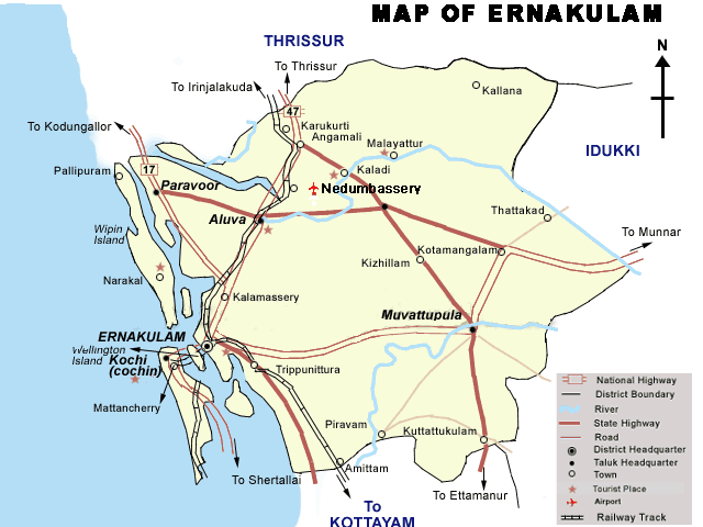
Ernakulam, located
on the coast of the Arabian Sea, is a cluster of islands networked by lagoons
and backwaters. Kochi, the headquarter of Ernakulam is the industrial capital
of Kerala. It is also one of the finest natural harobors in the world. No
doubt it is called the 'Queen of the Arabian Sea' Half the fun of visiting
Kochi is moving around on the local ferries. A conducted tour through the
winding waterways will take you to several quaint spots. |
|
|
|
|
|
|
|
|
|
|
|
|
|
|
|
|
|
|
|
|
|
|
|
|
|
|
|
Across the bridge into
the old city, there are bastions and streets built by the Portuguese over
500 years ago. It was here in St. Francis Church that the body of Vasco
Da Gama was originally buried. The enormous fishing nets on the sea front
of Cochin provide a charming view. |
|
|
|
|
|
|
|
|
|
|
|
|
|
|
|
|
|
|
|
|
|
TOP |
|
|
|
|
|
|
|
|
|
|
|
|
|
|
|
|
|
|
|
|
|
|
|
|
|
|
|
|
|
|
|
|
|
|
|
|
|
|
|
|
|
|
|
|
|
|
|
|
|
|
|
|
|
|
|
|
|
|
|
|
|
AREA : 3,032 sq.
km. -----------------------POPULATION : 2,734,333 |
|
|
|
|
|
|
|
|
|
|
|
|
|
|
|
|
|
|
|
|
|
|
|
|
|
|
|
The district
has a tropical humid climate with an oppressive hot season and plentiful
and seasonal rainfall. The hot season from March to May is followed by the
South West Monsoon season from June to September. The period from December
to February is the North East monsoon season, although the rain stop by
the end of December and the rest of the period is generally dry. |
|
|
|
|
|
|
|
|
|
|
|
|
|
|
|
|
|
Thrissur
|
|
|
|
|
|
|
|
|
|
|
|
|
|
|
|
|
|
|
|
|
|
|
|
|
|
|
|
|
|
|
|
|
|
|
|
|
|
|
|
|
|
|
|
|
|
|
|
|
The term Thrissur is
the abbreviated anglicised from of the Malayalam word "Thrissivaperur"
which means the town of the 'Sacred Siva'. Thrissur is the cultural capital
of Kerala, with a number of cultural training centres, of which 'Kalamandalam'
is the most famous one where traditional performing art forms of Kerala
is taught |
|
|
|
|
|
|
|
|
|
|
|
|
|
|
|
|
|
|
|
|
|
TOP |
|
|
|
|
|
|
|
|
|
|
|
|
|
|
|
|
|
|
|
|
|
|
|
|
|
|
|
|
|
|
|
|
|
|
|
|
|
|
|
|
|
|
|
|
|
|
|
|
|
|
|
|
|
|
|
|
|
|
|
|
|
AREA : 4,480 sq.
km. ----------------------- POPULATION : 2,376,160 |
|
|
|
|
|
|
|
|
|
|
|
|
|
|
|
|
|
|
|
|
|
|
|
|
|
|
|
The district
has a humid climate with a very hot season extending from March to June
in the western parts of the district whereas it is less humid in the eastern
parts. 75% of the annual rainfall is receieved during the south west monsoon
period which starts from mid June and extends upto September. |
|
|
|
|
|
|
|
|
|
|
|
|
|
|
|
|
|
Palakkad
|
|
|
|
|
|
|
|
|
|
|
|
|
|
|
|
|
|
|
|
|
|
|
|
|
|
|
|
|
|
|
|
|
|
|
|
|
|
|
|
|
|
|
|
|
|
|
|
|
In the past, this land
was known as Palakkattussery Etymologist trace the word Palakkad from Palanilam
meaning the dry area. Palakkad has a long history dating back to the Paleolithic
Period which was substantiated by a number of megalithic relics discovered
from this region. |
|
|
|
|
|
|
|
|
|
|
|
|
|
|
|
|
|
|
|
|
|
|
|
|
|
|
|
Palakkad is the land
of Palmyrahs and Paddy fields. Along with Alappuzha, Palakkad is a major
Paddy growing area of the state. It is often called as the “Gateway
of Kerala”. The Sahya Ranges bordering the region and the 32 k.m. long
gap in the mountains exert a dominant influence on the climate of the region.
|
|
|
|
|
|
|
|
|
|
|
|
|
|
|
|
|
|
|
|
|
|
TOP |
|
|
|
|
|
|
|
|
|
|
|
|
|
|
|
|
|
|
|
|
|
|
|
|
|
|
|
|
|
|
|
|
|
|
|
|
|
|
|
|
|
|
|
|
|
|
|
|
|
|
|
|
|
|
|
|
|
|
|
|
AREA : 3,548 sq.
km. ------- -------------POPULATION
: 3,093,190 |
|
|
|
|
|
|
|
|
|
|
|
|
|
|
|
|
|
|
|
|
|
|
|
|
|
|
|
|
Malappuram
has more or less the same climatic conditions prevalent elsewhere the state,
Dry season is from December to February, hot season from March to May, the
Southwest Monsoon from June to September and the North East Monsoon from
October to November. The South West Monsoon is usually very heavy and nearly
75% of the annual rains is received during this season. The climate is generally
hot and humid. |
|
|
|
|
|
|
|
|
|
|
|
|
|
|
|
|
|
Malappuram
|
|
|
|
|
|
|
|
|
|
|
|
|
|
|
|
|
|
|
|
|
|
|
|
|
|
|
|
|
|
|
|
|
|
|
|
|
|
|
|
|
|
|
|
|
|
|
|
The land of great poets
and writers, political and religious leaders, this district has carved a
place of it’s own in the history of Kerala. The Kings of Valluvanad,
the Zamorins, the Kings of Perumpadappu Swarupam and the Kings of Vettathunadu,
were the early rulers. The Portuguese, Mysore sultans and the Britishers
had their sway over this place, partly or wholly. But the unique social
and cultural heritage is preserved.
|
|
|
|
|
|
|
|
|
|
|
|
|
|
|
|
|
|
|
|
|
|
TOP |
|
|
|
|
|
|
|
|
|
|
|
|
|
|
|
|
|
|
|
|
|
|
|
|
|
|
|
|
|
|
|
|
|
|
|
|
|
|
|
|
|
|
|
|
|
|
|
|
|
|
|
|
|
|
|
|
|
|
|
|
AREA : 2,345 sq. km.
-----------------------POPULATION : 2,612,897
|
|
|
|
|
|
|
|
|
|
|
|
|
|
|
|
|
|
|
|
|
|
|
|
|
|
|
|
|
The district
has a humid climate with a very hot season extending from March to May.
The south west monsoon starts from the first week of June and extends up
to September. |
|
|
|
|
|
|
|
|
|
|
|
|
|
|
|
|
|
Kozhikode
|
|
|
|
|
|
|
|
|
|
|
|
|
|
|
|
|
|
|
|
|
|
|
|
|
|
|
|
|
|
|
|
|
|
|
|
|
|
|
|
|
|
|
|
|
|
|
|
|
The outer world came
to know about India in 1498 when Vasco da Gama came to Kozhikode and obtained
permission to carry out trade from here. Quickly in succession came the
English and Dutch. Disputes over the control of Calicut continued for a
long time until 1792, when the East India Company went into an agreement
with the local Zamori rulers to directly administer this area. |
|
|
|
|
|
|
|
|
|
|
|
|
|
|
|
|
|
|
|
|
|
|
|
|
|
|
Kerala was declared
a state in 1956, and today Kozhikode is one of the most important centers
of trade and business in this progressive state. |
|
|
|
|
|
|
|
|
|
|
|
|
|
|
|
|
|
|
|
|
|
TOP |
|
|
|
|
|
|
|
|
|
|
|
|
|
|
|
|
|
|
|
|
|
|
|
|
|
|
|
|
|
|
|
|
|
|
|
|
|
|
|
|
|
|
|
|
|
|
|
|
|
|
|
|
|
|
|
|
|
|
|
|
AREA : 2,132 sq.
km. -----------------------POPULATION : 671,195 |
|
|
|
|
|
|
|
|
|
|
|
|
|
|
|
|
|
|
|
|
|
|
|
|
|
|
Wayanad
has a salubrious climate. High velocity winds is common during the southwest
monsoon and dry winds blow in March-April. High altitude regions experience
severe cold. |
|
|
|
|
|
|
|
|
|
|
|
|
|
|
|
Wayanad
|
|
|
|
|
|
|
|
|
|
|
|
|
|
|
|
|
|
|
|
|
|
|
|
|
|
|
|
|
|
|
|
|
|
|
|
|
|
|
|
|
|
|
|
|
|
|
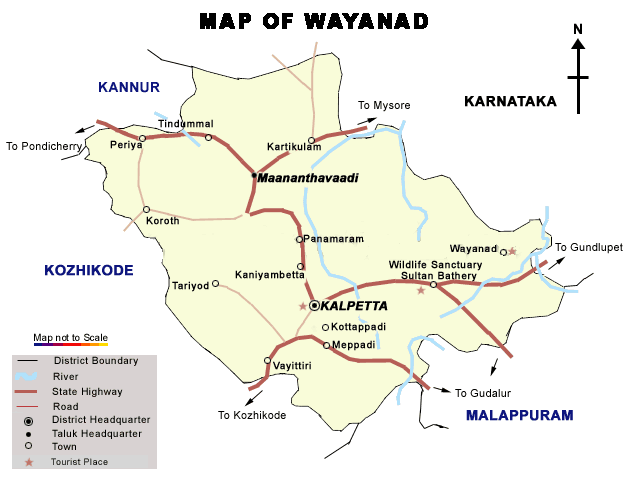
Historians are of the
view that organised human life existed in these parts, at least ten centuries
before Christ. Countless evidences about New Stone Age civilization can
be seen on the hills of Wayanad. The two caves of Ampukuthimala located
between Sultan Bathery and Ambalavayal, with pictures painted on their walls
and pictorial writings, speak volumes of the bygone era and civilization. |
|
|
|
|
|
|
|
|
|
|
|
|
|
|
|
|
|
|
|
|
TOP |
|
|
|
|
|
|
|
|
|
|
|
|
|
|
|
|
|
|
|
|
|
|
|
|
|
|
|
|
|
|
|
|
|
|
|
|
|
|
|
|
|
|
|
|
|
|
|
|
|
|
|
|
|
|
|
|
|
|
|
|
|
|
|
|
|
AREA : 2,997 sq.
km. ----------------------------- POPULATION
: 2,224,819 |
|
|
|
|
|
|
|
|
|
|
|
|
|
|
|
|
|
|
|
|
|
|
|
|
|
|
|
|
|
|
|
|
|
|
Kannur has
a humid climate with an oppressive hot season from March to the end of May.
This is followed by the South-West monsoon which continues till the end
of September. October and Novermber from the post-monsoon or retreating
monsoon season. The North East monsoon which follows, extends up to the
end of February, although the rain generally ceases after December. |
|
|
|
|
|
|
|
|
|
|
|
|
|
|
|
|
Kannur
|
|
|
|
|
|
|
|
|
|
|
|
|
|
|
|
|
|
|
|
|
|
|
|
|
|
|
|
|
|
|
|
|
|
|
|
|
|
|
|
|
|
|
|
|
|
|
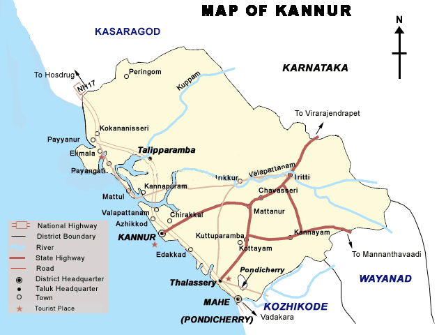
Rock-cut caves and
megalithic burial sites of the Neolithic age have come to light in certain
parts of the district. During the medieval age, several Arab scholars visited
the west coast. Balipatam, Srikantapuram, Dharmadom, bekal and Mount Eli
(Ezhimala) are some of the places, which figure prominently in their travelogues.
|
|
|
|
|
|
|
|
|
|
|
|
|
|
|
|
|
|
|
|
|
|
TOP |
|
|
|
|
|
|
|
|
|
|
|
|
|
|
|
|
|
|
|
|
|
|
|
|
|
|
|
|
|
|
|
|
|
|
|
|
|
|
|
|
|
|
|
|
|
|
|
|
|
|
|
|
|
|
|
|
|
|
|
|
AREA : 1,961 sq.km.
--------------- POPULATION : 1,070,629 |
|
|
|
|
|
|
|
|
|
|
|
|
|
|
|
|
|
|
|
|
|
|
|
|
|
|
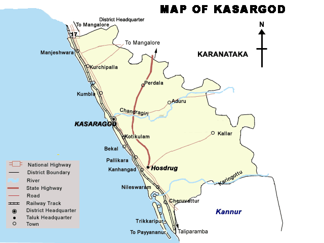
The southwest
monsoon starts towards the end of May or the beginning of June, heralded
by thunder storms and holds till September when the rain fades out. October
brings in the northeast monsoon. Dry weather sets in by the end of December.
January and February are the coolest months of the year. March, April and
May are generally very hot. |
|
|
|
|
|
|
|
|
|
|
|
|
|
|
|
|
Kasargod
|
|
|
|
|
|
|
|
|
|
|
|
|
|
|
|
|
|
|
|
|
|
|
|
|
|
|
|
|
|
|
|
|
|
|
|
|
|
TOP |
|
|
|
|
|
|
|
|
|
|
|
|
|
|
|
|
|
|
|
|
|
|
|
|
|
|
|
|
|
|
|
|
|
|
|
|
|
|
|
|
|
|
|
|
|
|
|
|
|
|
|
|
|
|
|
|
|
|
|
|
AREA : 32 sq. km.
----------- POPULATION : 52,000 |
|
|
|
|
|
|
|
|
|
|
|
|
|
|
|
|
|
|
|
|
|
|
|
|
|
|
|
|
Lakshadweep
has a tropical climate, with summer temperatures ranging from 35°c to
22°c and winter temperature between 32°c to 20°c. During monsoons
ship-based tourism is closed but helicopter services are available. Some
effect of the northeast monsoon is felt in October-November in the form
of light transitory showers which cool the place. |
|
|
|
|
|
|
|
|
|
|
|
|
|
|
|
|
|
Lakshadweep
|
|
|
|
|
|
|
|
|
|
|
|
|
|
|
|
|
|
|
|
|
|
|
|
|
|
|
|
|
|
|
|
|
|
|
|
|
|
|
|
|
|
|
|
|
|
|
|
These islands form
the smallest of the Union Territories of India, and are the country's only
coral islands. The main islands are Kavarrati, Minicoy, and Amini. Kavaratti
is the headquarters of these islands, while Bitra is the smallest of all,
with a nominal population. About 93 percent of the people in Lakshadweep
are Shafi school Muslims of the Sunni sect,and they speak Malayalam which
is the official language of Kerala. |
|
|
|
|
|
|
|
|
|
|
|
|
|
|
|
|
|
|
|
|
|
TOP |
|
|
|
|
|
|
|
|
|
|
|
|
|
|
|
|
|
|
|
|
|
|
|