|
Majestic views of the Potomac River and
connecting trails to Great Falls Park
 | Basic Conditions:
 | Over 5 miles of marked trails and
additional unmarked trails cover a variety of terrain passing through mature forest,
fields, and emerging woods. My favorite is the 2.5 mile sandy trail parallel to the
Potomac River shoreline.
|
| Shoreline trail connects to the trail
system at Great Falls National Park.
|
| Parking is available at the Visitor Center
lot. We park at Great Falls Park and ride over to Riverbend.
|
|
 |

|
| Mike & Hondo enjoy
the sandy trail |
A beautiful view of
the river |
| Potential Hazards:
| Hikers
|
| Outcroppings of rocks along the Great
Falls end of the shoreline trail
|
|
| Rules & Restrictions:
| Obey restrictions as indicated on signs.
|
|

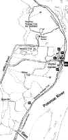
Park Map
Map thumbnail appears below. Click
on it to view larger map.
Use your browser's BACK button to return to this page
For further information, call the
park office at 703-759-3211.
| Directions from the Capital Beltway:
| Take Route 495 (the Beltway)
toward exit 13
|
| Exit at Exit 13 (Georgetown Pike,
Route 193)
|
| Travel west for 4.5 miles !! go slowly, this is a two-lane road with hills and curves !!
|
| Turn right on Riverbend Road and
travel 2 miles
|
| Turn right on Jeffery Road and
travel 1 mile to the Visitor's Center entrance
|
|
Please write if you have any questions or
comments: e-mail
 Visitors since 02/15/2000 Visitors since 02/15/2000
Last Updated 04/18/2000
|