[
KHT HOME ]
KAL-HAVEN TRAIL

You may trace the trail with a mouse pointer, or scroll down the page, for more information on some locations on the trail.
Links to online maps
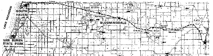
Kalamazoo
The eastern trailhead is on 10th Street, 1/2 mile north of H Avenue. The area has a large paved parking area, as well as a caboose that serves as an information station. (Photo)
Alamo - 6 th Street
(Williams) - 2 nd Street
Mentha
Formerly a large mint plantation, the buildings have fallen to ruin, and now its a long stretch of flat, dark, rich-soiled land. Timber Ridge ski area is visible to the North.
Up to Map
Kendall
BeeHive Farm
Before it closed, this country store and eatery (owned and operated by Al and Nancy Cassada) was a popular gathering spot for volunteers clearing the trail, and trail users.
Pine Grove
Gobles
A small community on M-40, first settled in 1864. (Photo)
Brookside Farms
Cattle crossing
Bloomingdale
Considered the mid-point of the Kal-Haven Trail which intersects the main 4 corners. (4-Way Stop Deli and Convenience store is appropriately named.) Old depot is now museum. Caboose provides information station. (Photos)
Up to Map
Berlamont
Lake 11
Nice fishing lake with public access site. Located between Berlamont and Grand Junction near the 13 mile post. (Photo)
Grand Junction - CR 215
Trail parking and rest stop located near crossing of active C.S.X. railroad tracks. (Photos)
Lacota
Very small town. Nice section when raceway is quiet.
Hinz Farm
Kibbie
Staging area for horseback riders.
South Haven
Western trailhead with safe transit under major highways (Blue Star, I-196). Adjacent to the Black River and marina. Parking area can be reached by taking Wells St. west of Blue Star Highway to N. Bailey Ave. (Photos)
Online Maps
Friends of Kal-Haven Trail (Yahoo! Maps)
Michigan DNR
TopoZone
 KHT Home Page
Outhouses, picnic tables and water - hand pumps
East-West landmark list
Created by John C. Waugh
8 December 1998
Modified on 26 August 2005