|
Harishchandragad (हरिश्चंद्रगड) |
|
|
  |
 |
|
 |
|
Difficulty Level
(very easy, easy, medium, slightly tough, tough)
|
Slightly tough |
|
Duration of the trek
|
2 day
|
|
When to visit
|
Anytime except Summer |
|
Nearest City / Location
|
Kalyan (कल्याण),
Murbad (मुरबाड),
Malshej Ghat (माळशेज घाट) |
|
Base Village
|
Kheereshwar (खीरेश्वर) |
|
कोंकण कडा (Konkan Kadaa)
The wonder of Nature... Dream of
trekkers... |
|
 |
 |
 |

कोंकण कड्यावरून सूर्यास्त (Sunset from Konkan
Kadaa) |
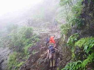
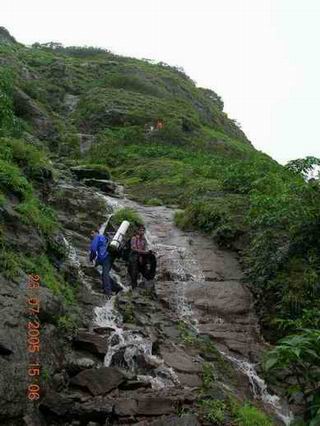
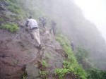
६०० फूट प्रस्तर (600 feet rock patch)
from Tolar Khind to
Harishchandragad... |
|

६०० फूट प्रस्तरावरील सुरुवातीच्या सळया
(Railings on initial part of rock patch) |
 |
 |
 |
|
 |
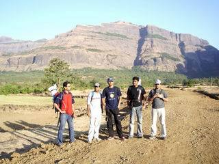
Harishchandragad behind

On the way to the fort |
|
ट्रेकर्सची पंढरी - Harishchandragad is king of
fort treks. It is called pilgrimage of trekkers. Trekking@sahyadri reaches
its milestone when you reach Konkan kadaa (कोंकण कडा) of Harishchandragad.
Harishchandragad hosts many attractions that really astonish us. This trek
offers you everything - forest trekking, rock patches, long walks, second
highest peak of Maharashtra, amazing natural variations, huge creations of
volcano, ancient glory of Hindu carvings and the peak of all - Konkan kadaa.
The trek is in 4 steps.
-
Reach Kheereshwar from Bus stop– 1 hour walk on the wall of Dam
-
Climb up to Tolar Khind (तोलार खिंड) – 1 and ½ hour climb
through Harishchandragad Kalsubai forest sanctuary.
-
Climb the 600 feet rock patch to reach the top of the fort
Harishchandragad – 45 minutes climb on the rock patch.
-
Walk on the fort to find the Harishchandreshwar temple - 1
and
½
hour
There are other routes to the fort -
-
Way by Tolar Khind
which is most common path from Kheereshwar. The description as mentioned
above.
-
Way from Zunzar Darwaja
or Rajdarwaja (झुंझार दरवाजा / राजदरवाजा) takes you to the base of
Balekilla. This way is frequently used by local people and you can take a
guide from Kheereshwar. this route takes less time as compared to way by
Tolar khind.
-
Nalichi vaat (नळीची वाट) via Konkan kadaa is tough
and takes about 1.5 days
-
Way from Sadhale Ghat -
There is also a way from Sadhale Ghat (साधले घाट) that takes you near
Konkan kadaa.
|
|
 |
 |
|

|
-
Get down at Khubi-Phata (खुबी फाटा) (next stop to
Malshej Ghat). You will see a grand dam at the left side.
-
Walk over the dam wall for an hour to reach
Kheereshwar.
(खीरेश्वर). You can also visit the
Kheereshwar temple
which 1200 years old.
-
Start climbing for Tolar khind (तोलार खिंड). The way
passes through streams of water, some waterfalls and Harishchandragad-Kalsubai
Forest sanctuary.
-
Climb the 600 ft rock patch. Railings are
provided at some places. Be quite careful while climbing.
Do not wear slippery shoes.
-
The top of the fort is very vast with large
hills and hundreds of streams. Search for the
Harishchandreshwar temple (about 1 and ½ hours walk on the
top of the fort.)
-
You have to cross seven hills on the fort
to reach this temple. Way on the sixth hill passes through
dense forest. Seventh hill has a small ghumti (small
temple) and a water tank. You can see Harishchandreshwar
temple from here in the valley of seventh hill. The arrow marks are present.
|
|
 |

हरिश्चंद्रेश्वर मंदिर (Harishchandreshwar Mandir)
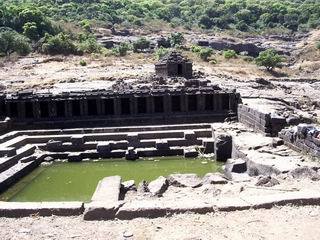
पुष्करणी (Pushkarani)
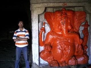
गणेश गुहा (Ganesh Guhaa)
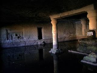
केदारेश्वर गुहा (Kedareshwar Guhaa)

रोहिदास शिखर (Rohidas Mountains) from Konkan Kadaa

|
From
Kalyan to Khubi Phata
|
Every half an hour bus to Ale Phata / Nagar
(आळे
फाटा / नगर).
Get down at Khubi Phata stop.
|
|
First bus |
5.30am from Kalyan |
|
Last bus |
12.15am from Kalyan |

|
Time to climb |
1 hour
from Khubi Phata to Kheereshwar
2 and ½ hours
to the fort entry from
Kheereshwar
1 and
½
hours to the temple on the fort form entry |
|
Food |
Available at Kheereshwar
and Khubi-Phata. |
|
Drinkable Water |
Available on the fort and
Khireshwar |
|
Shelter |
Harishchandreshwar temple and Ganesh
caves |
|
-
This is 3000 years old
fort – one of the oldest forts of Maharashtra. It has
history of Puraanas and Pandavas. The fort is really vast
and you really get astonished to see the huge plateau on
the top having several hills.
-
६०० फूट प्रस्तर
(600 feet rock patch) - This is also one of the
attraction for trekkers. The rock patch has railings at
some places and some of them are broken. You can see deep
valley of dense forest below.
-
हरिश्चंद्रेश्वर
मंदिर (Harishchandreshwar Mandir) - This is 2000 years old
Harishchandreshwar temple of Lord Shiva which is 16 meter in
height. The carvings on the temple are really breathtaking
inside. External carvings have been little bit faded due
to wind and rain, both of which are horribly strong on the
fort throughout the year. Stay at night is possible in the
caves behind the temples. One of the cave bears a huge
vessel which is used to create prasad on Mahashivratri.
this is the time when celebrations are made at Harishchandreshwar
temple every year. Some of te caves have other Hindu idols
and some have drinking water.
-
पुष्करणी (Pushkarani)
- In front of the Harishchandreshwar Mandir,
there is a sqaure lake with steps at all sides and series
of small temples (घुमट्या) at one side. This is called
Pushkarni. This was used for water sports, swimming and
religious rituals. Pushkarani was considered sign of
glory.
-
गणेश गुहा (Ganesh
Guhaa) - Just near the Harishchandreshwar temple are
Ganesh caves. Events in the life of King Harishchandra (1000BC) are carved here.
One of the caves has 8 feet tall Ganesh idol. Ganesh caves
is the place where Tapashwi Changdev had stayed for more
than thousand years in hibernate state. From here only he
went to visit Saint Dnyaneshwar in 1200AD. Ganesh cave is
better place for night stay.
-
बालेकिल्ला
(Bale killa) or citadel is another highest point on
Harishchandragad. Balekilla has fortification made up of
stone and Zunzar Darwaja or Rajdarwaja (झुंझार दरवाजा
/ राजदरवाजा)
-
केदारेश्वर गुहा
(Kedareshwar Guhaa) - Kedareshwar cave contains
4 feet long Lord Kedareshwar idol surrounded by ice cold water.
This cave was originally balanced on four pillars out of
which three are now in broken state. Carvings of events in
Shivpuran are really beautiful. If you want to do
pradakshina to Lord Kedareshwar, you need to walk in 2
feet deep chilling cold water.
-
कोंकण
कडा (Konkan Kadaa) – The wonder of Nature – Dream of trekkers.
This is 2000 feet deep, straight, concave, semicircular,
vessel shaped edge of Harishchandragad. (वाटीच्या आकाराचा
कडा) The wind is really mighty here. Coins thrown down
come back due to wind force. The semicircular vaati (वाटी
or vessel) of Kokan kadaa can be seen from Malshej Ghat
for a while. but after some time Rohidas shikhar covers
its view. Sunset from Konkan kadaa is famous since
nothing is much taller around than the place you are.
-
रोहिदास शिखर (Rohidas
Mountains) - This pyramidal shaped mountain can be
seen from Konkan kadaa and throughout the Malshej Ghat.
The mountain is not actually part of Harishchandragad.
-
तारामती शिखर (Taramati
mountain) - Taramati is second highest peak in
Maharashtra. Kalsubai - the highest peak - can be seen
from here. This whole range of Sahyadri is exceptionally
high. the igneous rock generated in thousands of years old
volcano were suddenly cooled by rains to form really steep
rock patches everywhere. Taramai mountain gives clear view
of Malshej Ghat, Kheereshwar, Hadsar fort, Naneghat,
Kalsubai mountain, etc. Taramati Shikhar has many Shiv-ling
(शिवलिंग) and go-mukh (गोमुख) on its way.
-
There are many
other remnants of the old rishi ashram that was
flourishing here. Hundreds of Shivling (शिवलिंग) and water
tanks are present here and there.
|
|

तारामती शिखर (Taramati mountain)
from 4th hill of Harishchandragad
|
|
Other
pictures of Harishchandragad


Pictures of
Harishchandragad trek 01
(July 2005)
Pictures of
Harishchandragad trek 02
(March 2006) |


