Description:
Chippewa Harbor campground sits on a
huge weathered rock face. The shelters
are set back off of the rock surface, but the open area is all rock. This rock over looks the Harbor and the entrance
to the Harbor with Lake Superior as a backdrop. From the dock you can see a small island in the channel that is
possible to wade out to. The shore on
Lake Superior outside of the harbor is bordered with a huge rock cliff.
Rating: *****
Uppers:
Chippewa Harbor is mostly at the end of
a trail, so it is a secluded spot most of the time. The people going to Chippewa are going there to be there, so at
least you will be with good company.
Walking around is an adventure because of all the thresholds between the
frontiers of different environments:
harbor, lake superior, marsh land, rocky areas and forests. Off in the woods you can find an old
schoolhouse. There was an old desk in
the house last time we saw it. It is
very small, but really wonderful.
Downers:
The real downer is the hike out to
Chippewa because it is a dead end hike.
However, that makes it much more unpopular. It isn’t on the way to anywhere.
The dock is used often, and the ferry stops there. Nothing like a huge ferry stopping at your
dock with people to spoil the intimacy of feeling away from everything.
Information:
Chippewa Harbor Campground has 3 consecutive nights maximum stay, 2 individual tent sites, 4 shelters, and 1 group site. It has canoe and kayak access, campfires allowed in provided grills only, and trail access.
Day
Hikes:
Lake Mason is an inland lake with tall
swamp grasses marshy surroundings.
Moose frequent this lake early in the morning and night. If you like climbing rocks, you can climb
out towards lakes superior.
Distances:
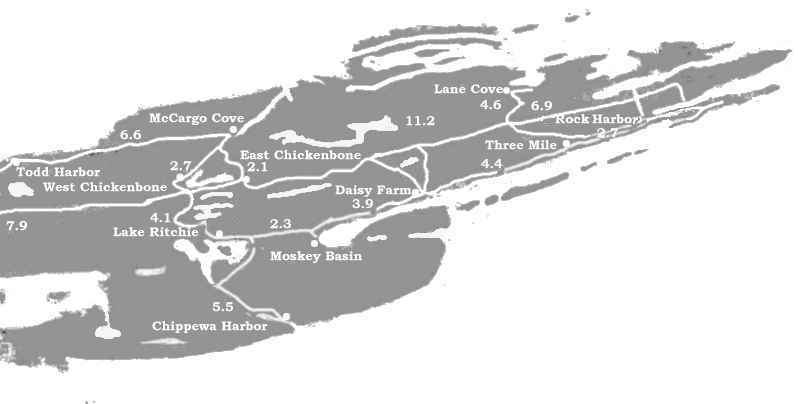
Lake Ritchie 4.1, Moskey Basin 6.2, West Chickenbone 9.1, East Chickenbone 10.5, McCargo 10.6
Description:
McCargo is the beginning or the end of the Minong Ridge. It sits overlooking the end of a long cove. You can not see Lake Superior from the protect cove, but you get a view of the forested hills and ridges. Swampy marshlands border McCargo to the south, coming off the Chicken Bone trails. The Minong to the west of the site is dryer and rockier, but also has dense forest. North the the site you have heavy forested small hills and ridges. Down the cove toward Lake Superior is Birch Island.
Rating: *****
Uppers:
McCargo Cove has been one of our favorite spots to see moose. You often wake to splashing in the morning as mouse move around in the shallow waters across from the campground. At night as the sun is setting you can watch the sunlight fade on the moose munching the on the aquatic plants while you lay on the dock.
Downers:
McCargo seems to be very popular with the fishing boats and sail boaters. The acoholo ban helps, however the boaters seem to just drink inside their boats and ignore the rule. On one particular trip we left the campsite in mid afternoon for our traditional day hike out to the Minong Mines. We arrived back at our campsite to a dock stacked with 5-6 boats. It made it hard to sit on the dock and watch the moose or to even pump water.
Information:
McCargoe Cove Campground has 3 consecutive nights maximum stay, 3 individual tent sites, 6 shelters, and 3 group sites. It has canoe and kayak access, trail access, no alcohol allowed, and fires in the community fire ring only.
Day Hikes:
Within a few miles are the old Minong mines. Huge tailing piles can be climbed and some old mine shafts can be walked into a little ways. They are all shallow so there is little danger except for the mines with vertical shafts that are filled with water and who knows how deep.
Distances:
East Chickenbone 2.1, West Chickenbone 2.7, Chippewa Harbor 10.6, Daisy Farm 8.2, Hatchet Lake 10.5, Lake Ritchie 6.5, Moskey Basin 8.6, Todd Harbor 6.6
Description:
Lake Ritchie would be a great place for
kayaks or canoes. It is a one of the
more beautiful inland lakes and makes a great place to camp.
Rating:
****
Uppers:
Along the trail to Chippewa Harbor is
the most beautiful trail along an inland lake.
The campsites are in a great location (although the trail isn’t) on the
lake.
Downers:
The sites are rocky and the trail goes
through your front yard, between you and the shoreline. Gives you a hemmed in feeling. (JC)
Information:
Lake Richie Campground has 2
consecutive nights maximum stay, 4 individual tent sites, no shelter, and
2 group sites. It has canoe and kayak access, trail access, and
self-contained stoves only.
Day
Hikes:
Hiking up to Lake LeSage if it isn’t on
your path would be worth the time and energy.
If you are ambitious you can hike to Lake Mason or Chippewa Harbor.
Distances:
Chickenbone West 4.1, Chickenbone East
5.5, Daisy Farm 5.5, Hatchet Lake 10.9,
Moskey Basin 2.3, McCargo Cove 6.5.
Description:
East Chickenbone is on top of a
forested hill that overlooks the lake.
Although you can’t see much of the lake from the campsites. You have to hike down a trail to get to the
lake.
Rating:
**
Uppers:
After sleeping on the rocky tents sites
at East Chickenbone you appreciate any of the other campsites for the rest of
the trip.
Downers:
There isn’t much to see as far as a
view goes. The forest and swamps around
it are awesome, but anywhere on the island you can find similar forests and swampy
areas. Your water source is found down
a long trail (probably the furthers away from the campsites on the island) that
ends in a muddy hole hemmed in by swamp shrubs. (JC)
Information:
Chickenbone East Campground has 2
consecutive nights maximum stay, 3 individual tent sites, no shelters, and 1
group site. It has canoe and kayak access, trail access, and
self-contained stoves only.
Day
Hikes:
McCargo Cove and the Minong Mine aren’t
too far away, but would make a long day hike.
If you were taking a day of rest, it would be worth the hike.
Distances:
West Chickenbone 1.8, Daisy Farm 6.1, Hatchet Lake 9.3, Lake Richie 5.5, Chippewa Harbor 10.5,
McCargo Cove 2.1, Moskey Basin 7.8, Todd Harbor 8.7
Description:
West Chickenbone is on chickenbone
lake. On the south side is a steep
climb up the Greenstone ridge, and to the north the trail follows the lake.
Rating:
***
Uppers:
A great place to watch for moose and to
enjoy the beauty of the inner lakes on Isle Royale. The sites are nice and the lake is close.
Downers:
West Chickenbone seems to be a popular
site to stay at because of its location.
The hike up to the greenstone is short, but extremely steep and rough if
you are carrying a full pack. (JC)
Information:
Chickenbone West Campground has 2
consecutive nights maximum stay, 6 individual tent site, no shelters, and 3
group sites. It has canoe and kayak access, trail access, and
self-contained stoves only.
Distances:
East Chickenbone 1.8, Chippewa Harbor
9.1, Daisy Farm 7.9, Hatchet Lake 7.9, Lake Richie 4.1, McCargo 2.1, Moskey 6.4, Todd Harbor 9.3
Description:
The shelters are all along the shore of
Moskey Basin in a crescent shape looking out onto the water of the basin. A long dock is paralleled by a rock
pennisula covered with small trees, bursh, moss and bird droppings.
Rating: ****
Uppers:
A great place for moose. They even come to you sometimes. We had a moose walk up to our shelter and browse
outside of it. Actually, it walked down
by the dock and had a group of people following it for about 30 minutes,
watching and snapping pictures.
Eventually, everyone got bored and went back to their sites. The dock and rock pennisula are a great place
to talk to fellow campers.
Downers:
The popularity of this place means
shelters are usually inhabited by early afternoon and it is often crowded. Anyone can change their intinirary at
anytime so even if you are supposed to be there, you might have to share a
group site.
Information:
Moskey Basin Campground has 3
consecutive nights maximum stay, 2 individual tent sites, 6 shelters, and
2 group sites. It has boat access, canoe and kayak access, self-contained
stoves only allowed, and trail access.
Distances:
East Chickenbone 7.8, West Chickenbone
6.4, Chippewa Harbor 6.2, Lake Richie
2.3, McCargo 8.6, Three Mile 8.3
Description:
Daisy Farm seems to be named after the
field of wildflowers near the dock. Most
shelters parallel the shore and each site has a trail to the water.
Rating: ****
Uppers:
It’s
a great location.
Downers:
Again, the popularity of Daisy Farm
makes it hard to find a shelter in the late afternoon. The dock is often popular with swimmers,
people pumping water, boaters, kayakers and the like. Concessions rents out canoes and small boats with motors and they
often frequent Daisy.
The BUSIEST backcountry campground on
Isle Royale, but it is the
largest as well, and even if you don't
get a shelter, there are some nice
secluded tent spots back in the denser
woods. feels like you have more
privacy than you actually have, away
from the bustle of the shelters and
dock.
(JC)
Information:
Daisy Farm Campground has 3 consecutive nights maximum stay, 6 individual tent site, 16 shelters, and 3 group sites. It has canoe and kayak access, self-contained stoves only, and trail access.
Day
Hikes:
Mount Ojibway is probably the best
place for a view of the Eastern end of the Island. Going out of you way to hike Ojibway is almost a necessity. Siskiwit Mine is in close proximaty to Daisy
Farm and is a nice spot for a picnic lunch or for a rest.
Distances:
East Chickenbone 6.1, West Chickenbone
7.9, Chippewa Harbor 9.7, Lake Richie 5.8, Lane Cove 7.2, McCargo 8.2, Moskey
Basin 3.9, Rock Harbor 7.1, Three Mile
4.4
Description:
Three
Mile is wedged into the rocky shore of Isle Royale. The chain of islands making Rock Harbor into a harbor give these campsites
protection from the lake and also a view of Tookers Island and Mott
Island.
Rating: ****
Downers:
Anything
Rock Harbor is popular and Three Mile is no exception. The popularity is the only thing holding
three mile back from a good ***** rating.
Information:
Three
Mile Campground has 1 consecutive night maximum stay, 4 individual tent site, 8
shelters, and 3 group sites. It has trail access, canoe and kayak access,
and self-contained stoves only are allowed.
Day Hikes:
Mount
Franklin and Suzy’s Cave are close.
Suzy’s Cave is a nice little stop on your way into Rock Harbor, but
don’t get your hopes up for a real cave.
It is more like a hole in a rock.
Mount Franklin, I’m sure, affords a beautiful view, although I’ve never
hike up that way.
Distances:
Rock Harbor
2.7, Daisy Farm 4.4, Lane Cove 4.6,
Moskey Basin 8.3, East Chickenbone 10.5
Description
Rock Harbor is actually the large
harbor that stretches for miles all the way to Moskey Basin. Rock Harbor campground and ranger station is
actually a tiny harbor within Rock Harbor.
It is almost like a small town with old buildings crowding around the
harbor. It is a pleasant place for a
ranger station.
Uppers:
French fries… err… food, dining,
grocery, bookstore… all sorts of neat little things are tucked into the
Rock.
Downers:
Popularity,
privacy.
Information:
Rock
Harbor Campground has 1 consecutive night maximum stay, 11 individual tent
sites, 9 shelters, and 3 group sites. It has trail access, canoe and
kayak access, treated water supply, and self-contained stoves only are allowed.
Distances
Distances:
Three Mile
2.7, Lane Cover 6.9, Daisy Farm 7.1