


An historic US highway endpoint at Cumberland Gap, VA
Research: H.B.
Elkins. Photo credits: Robert
Droz; Michael
Summa
Within the boundaries of Cumberland Gap National Historic Park is the site
of a highway junction that no longer exists. The NPS map below shows the current
road configurations, but I've highlighted the route of old US 25E in blue, and
old US 58 in orange:

The old junction was right by the "e" in the label for "Iron
Furnace". Originally this junction marked the west end of US 411 [I], but
that route was retired in 1933 when an extension of US 421 swallowed it up.
The following year, US 58 was also extended west to Cumberland Gap, so US 58
and US 421 shared a common terminus there for the next 16 years. In 1950, US
421 was rerouted such that it no longer serves this part of Virginia, but the
west end of US 58 remained there for the next several years. The USGS map below
was made when that was the case:

In 1996, the Cumberland Gap Tunnel opened to traffic (you can see it under
construction on the map above: the purple lines at bottom center). This meant
US 25E no longer entered Virginia at all, and was no longer routed through the
actual Cumberland Gap (the physical mountain pass). The National Park Service
announced plans to take advantage of this situation by restoring the road through
the Gap back to the condition of its 1800's precursor. As Robert
Brooks puts it:
"This is a unique spot: where a historic terminus was removed to open
a gateway to an even more historic road. The old US 58 road cut has been restored
to a hillside! When I visited in June 2005, the only way you could tell there
had been a highway there was that there was a gap in the trees. The former
terminus of US 58 is now the Daniel Boone Parking Lot, which provides access
to a trailhead. It's the starting point for tours of the Gap Cave, a former
commerical cave that was finally bought by the Parks Service in the 1990's.
In its tourist trap days, US 25E passed right by the cave entrance, and the
building housing the gift shop was on the other side of the highway. The first
challenge faced by prospective cavers was getting across the road alive! Today,
if you take the trail toward the cave and look back, you get a great view
of the former terminus, now part of a peaceful walk in the mountains."
Robert Droz was at the site in 1998, and had a chance to take several photos
before the old highways had been completely erased. Here's one showing what
was left of the old junction:
 Droz,
1998
Droz,
1998
That's along what was once southbound US 25E. It connected with the road in
the background, and continued off to the right. US 411 / 421 / 58 used to begin
on the left side of the photo, right where the bare hill is. There was once
a road cut there, but after US 58 had been relocated to its current alignment,
the original hillside was "rebuilt". Robert has put together an interesting
site with several more photos and lots more info here.
The photo below was taken pre-Tunnel, and it shows what was the first reassurance
marker heading east from there:
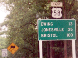 Summa, 1992
As you can see on the first map, US 58 now ends at a trumpet interchange with
US 25E just east of the tunnel, and just outside the town of Cumberland Gap
TN. During the 1980's and 1990's, US 58 had an "interim" endpoint
- on the map above, it's the intersection shown just south and east of the original
endpoint. You can view photos of both the interim terminus and the modern terminus
on my main US
58 page.

Page (in its original form) created 11 November 1999; last updated
25 February 2006.
|