
![]()
![]()
![]()
![]()
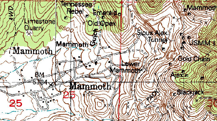
Map of Mammoth
USGS 7.5 Minute Series Maps
"Tintic Junction" 1992 And "Eureka" 1992
History of Mammoth
Mammoth was the result of prospecting and claims [the first made on February 26, 1870 (Notarianni, 16)] after some initial discoveries of silver outrcroppings. Supposedly one of the prospectors stated 'Boys, she's a mammoth strike! We've got ourselves a mammoth mine (Thompson, 63-64).' This was how Mammoth received its name.
The owners of the mine were led by one Charles Crimson. Some developments were made on the mine but the results weren't that encouraging; perhaps earlier enthusiam was dampened by the realities of difficult conditions. Crimson decided he wanted out of the mining business and looked for a way out.
Crimson found his opportunity in about 1873, in the McIntyre brothers, Sam and William. The McIntyres were passing through the area with their cattle destined for Salt Lake City. Crimson and the McIntyres met and the former talked the brothers into trading their cattle for the "biggest share of the mine" (Florin [page number unknown).
Sam and William invested some money into the mine and sank [I assume Crimson's original shaft] a deeper shaft. They were rewarded with for their efforts for they discovered a body of ore "which produced gold, silver, lead, copper and bismuth for seventy-five years" (Carr, 91).
Other mines soon followed and the rush was on. As in all mining areas towns sprang up to meet the needs of prospectors and miners. Mining related operations were set up by the addition in 1890, of two mills, the Mammoth and the Sioux (91).
But as Mammoth was developing a new town was started, approximately one mile away, Robinson. [I have found two conflicting accounts of the "birth" of Robinson. I present the two versions so one can make their own judgment and perhaps help me clarify/correct/ammend what is presented here.]
According to Thompson (91) a man by the name of George H. Robinson was supervisor of the Sioux Mill, which was outside of Mammoth proper near the mouth of the canyon. Robinson laidout a townsite and named the place after himself.
According to Notarianni (48) Robinson was supervisor of the Mammoth mill and it was this mill which was constructed some distance from Mammoth and the townsite laid around.
An old map showing the location of the Mammoth mill seems to support Notarianni but then one finds another mill near the Mammoth, the Farrell Mill which was also known as the Sioux mill. The map depicts both the Mammoth and Farrell mills in Robinson, not in town of Mammoth proper.
In either case a man named Robinson did layout a townsite and named it after himself. The formation of Robinson occurred during the years 1893-1895 (Notarianni, 48). To compare the growth of the Mammoth and Robinson, Notarianni points out that in the year 1895, 12 residences were added to Robinson, while 25-50 were added to Mammoth.
The McIntyre brothers eventually tired of G. H. Robinson's eccentricities and fired him. But G. Robinson's dismisal did not mean the end of his town.
So now we see two townsites in close proximity, so close that they grow into each other. Because of these two co-existing entities Mammoth was sometimes referred to as Uppertown (or Upper Town) or Upper Mammoth, while Robinson was referred to as Lowertown (or Lower Town) or sometimes as Lower Mammoth. In general one could divide Robinson and Mammoth into business and residential areas respectively.
The Utah Western Railroad built rails into Robinson and ore from both towns was shipped from Robinson (Thompson, 63; Carr 91).
Each town had its own post office, which was rather redundant. Eventually the two post offices were both disbanded and a new one was opened where the two towns met. This place where the two towns converged was called Middletown (Thompson, 63). This all occurred sometime after Mammoth was incorporated in 1910. At Middletown, one could find an LDS church and a school house, both of which served both towns (Notarianni, 49). Incidentially Mammoth's first mayor was James Hutchison (Carter, 140) but I do not know the date he started office.
Mammoth had its own newpaper called The Mammoth Record. I wonder if G. Robinson had still been around if he would have started his own paper? Several business establishments and services were found serving this area: general and dry good stores, stables, lumberyards, a pool hall, a book store, a Chinese laundry, barbershops, blacksmith shops, lawyers, doctors, a baseball field, an opera house [with a capicty for 300 people built in 1896 (Notarianni, 48)] , movie theater, a confectionary and, of course, saloons. Mammoth, in response to a costly fire (but not the first fire to breakout) raised a volunteer fire department in 1912 (97).
To view the extent of the commercial activity in Mammoth Notarianni (94) gives us some useful figures taken from Polk's Business directory. Here are the number of business establishments listed along with the years:
| 1912 | 54 | |
| 1918 | 27 | |
| 1920 | 27 | (page 124) |
| 1934 | 3 | (page 124) |
What is even more remarkable was the fact that there were four two-story hotels all co-existing with each other, although you'd never guess such structures existed by looking at Mammoth today. The hotels were The Mammoth (of course), the Scott House, The Mathews [consisting of 42 rooms (Notarianni, 70)], and the Kirkendal. The Kirkendal was later converted to be used as a hospital, the Tintic Hospital to be exact (Carr, 91).
At this point let us look at population figures for the area, again given to us by Notarianni (124):
| 1900 | 1385 |
| 1910 | 1828* |
| 1912 | 1700** |
| 1920 | 1125 |
| 1930 | 750 |
* Notarianni states however, "Reportedly, in 1910 there existed...a population of 2,823" (89,92). I have also heard that the population may have reached 3,000 inhabitants at Mammoth's peak.
** Page 94
For a bit of demographic information one can view the number of children in school by gender. In 1909, for example, there were 237 boys and 240 girls according to a school census (Notarianni, 81).
As with most mining camps the existence of the town was dependant upon the fortunes of the mines. Decreasing values of ore and increased production and mining costs eventually shut the mines down. And with the mines shut down the need for Mammoth was nullified.
On September 19, 1929 a petition for disincorporation was filed; the issue voted on (153 in favor, 118 against); and disincorporation finally came on November 19, 1929 (Carter, 140).
Mammoth today can't be considered a "complete" or "true" ghost town because people still live there. There are no services to be found there, even drinking water has to be hauled in. There is still some sort of mining activity taking place in Mammoth but I'm not sure of the extent or exact nature of the activity.
MINES AT MAMMOTH (Not an all inclusive list.)
Ajax, Black Jack, Grand Central, Lower Mammoth, Victor.
RECENT NEWS RELATING TO MAMMOTH
On July 3, 1999 a fire caused the evacuation of the residents (listed as 60) of Mammoth. The fire started as two smaller fires near some railroad tracks. As the roads were closed down near the fire, vehicles were being turned away and rerouted. One vehicle was a Sperry Oil Truck. As the truck was turning around the fire jumped the road and caught the truck on fire, which ignited its contents of 11,000 gallons of fuel.
No homes were burned in Mammoth, but fire did consume nearly 62,000 acres and caused 1.5 million dollars in damage (to fences, pumps, irrigation systems, etc.). By July 7 the fire was contained.
Although Mammoth didn't recieve damage, the ghost town of Silver City did. It is unfortunate that fire destroyed what little wooden structures were left. A railroad loading ramp was destroyed and the fire cinged the Silver City cemetery. If any good came of the fire it is that the fire cleared away all the sage brush and one could see the remaining concrete structures that lay hidden from casual view.
HISTORICAL MAPS OF MAMMOTH
A USGS map from 1913, scale 1:9600. (The scale might not be entirely accurate due to scanning, cropping, and resizing). Depicts Mammoth and Robinson.
(535KB)
Another USGS map. I'm not sure of the date and scale however. This map depicts Robinson (note the location of the Mammoth and Farrel Mills.
(62KB)
MODERN AERIAL PHOTOGRAPHS OF MAMMOTH (U.S. Geological Survey July 17, 1996)
A good "bird's eye" view of Mammoth as it looked in 1996.
(30KB)
A closer look at Mammoth proper, 1996.
(36KB)
Sources: (See Reference Section for full bibilographic information on select sources.)
Carr, Stephen L. The Historical Guide to Utah Ghost Towns
Carter, Kate B. Our Pioneer Heritage Vol 14. Daughters of Utah Pioneers, 1971 Salt Lake City, Utah
Florin, Lambert Ghost Town Album (c) MCMLXIII Superior Publishing Company,
----- Seattle, Washington
McCune, Alice Paxman History of Juab County Juab County Company of the Daughters of
----- Utah Pioneers, 1947
Notarianni, Philip F. Faith, Hope, & Prosperity: The Tintic Mining District
Thompson, George A. Some Dreams Die: Utah's Ghost Towns and Lost Treasures
Pictures
Click on the thumbnail for larger photo.
All photos copyright (c) Chad Carter 2000.


All photos copyright (c) Chad Carter 2000.


All photos copyright (c) Chad Carter 2000.

Utah Ghost Towns and Mining Camps
All photos and graphics (unless noted otherwise)
copyright (c) Chad Carter 2000.
Created in 800X600 resolution.