Conceptual Models and Data Models of Geographic
Information System in Developing Sustainable Ecotourism;
Feasibility in Mount Rinjani National Park
Introduction
John Neisbitt in his book Megatrend said that information has become the most important thing in the future, especially in the third millennium. All information including information about location, and questions like where are the position, what is containing there and how to go there will become popular. Since 1980s, scientists in mapping and information technology have developed information system to help people make decision by collecting, managing and analyzing the data. More recently, they tried to relate attribute data with the location, which is known as spatial data. This system became known as Geographic Information System (GIS).
Geographic Information System (GIS) ‘is at its simplest level a technology that enables decision-makers to explore the geographical dimension of data’ (Grimshaw, 1993: 206). GIS also can define as a toolbox; that is containing tools for collecting, storing, retrieving, transforming, displaying (Burrough, 1986: 6), checking, manipulating and analyzing (DoE, 1987: 132) spatial data. In a GIS, information is given by geographic coordinates such as latitude, longitude or other grid coordinate systems, and from further data processing, other information such as names, number, symbols, graphics, charts also can be displayed. GIS also has ability to combine and analyze variables from data to fulfill some criteria to result information that is needed.
To date, the relationship between GIS and tourism field becomes closer and complementary. As mentioned above, GIS has a capability to analyze the spatial data, and it is a core of tourism development planning activities. Many researches in applying GIS in tourism field have been done. Carver in 1997 assessed the analysis capabilities of GIS in tourism related issues such as perception and definition of wilderness, Cleverdon in 1993 used GIS to find that tourism growth is exacerbating an often stretched and overloaded tourism infrastructure (Bahaire and White, 1999: 163).
Tourism industry rapidly growing, it is important to consider the impact of development on the environment and local communities. This concern has given rise to sustainable tourism which seeks to balance the needs of the tourism industry and host communities while ensuring future growth. Fundamental to this concept are the basic principles of quality, continuity and balance.
Sustainable Ecotourism (Definitions)
The Canadian Environmental Advisory Council (CEAC) defines ecotourism as an enlightening nature travel experience that contributes to the conservation of the ecosystem while respecting the integrity of host communities (Scace et al., 1992: 14)
Ecotourism can be defined as travel to fragile, pristine, and usually protected areas that strive to be low impact and (usually) small scale. It helps educate the traveller; provides funds for conservation; directly benefits the economic development and political empowerment of local communities; and fosters respect for different cultures and for human rights (Honey, 1999: 25). Another definition is travel that combines preserving the natural world and sustaining the well-being of the human cultures that inhabit it (Hunt, 1998).
According to Honey (1999), ecotourism can be identified with seven factors below:
1. Involves travel to natural destinations. Remote areas, whether inhabited or uninhabited, and are usually under some kind of environmental protection at the national, international, communal or private level are include in this destinations.
2. Minimize impact, for example by using either recycled or plentifully available local building materials, renewable sources of energy, recycling and safe disposal of waste and garbage, and culturally sensitive architectural designs.
3. Builds environmental awareness, it means education for both tourists and residents of nearby communities. The Ecotourism society’s guideline state "to learn about the place and people to be visited" and "to minimize their negative impacts while visiting sensitive environments and cultures"
4. Provides direct financial benefits for conservation. For examples: raise funds for environmental protection, research and education through a variety mechanisms, including park entrance fees, tour company, hotel, airline, airport taxes and voluntary contributions.
5. Provides financial benefits and empowerment for local people. The local community must be involved with and receive income and other tangible benefits (potable water, roads, health clinics, etc.) from the conservation area and its tourist facilities.
6. Respects local culture. Ecotourism is not only "greener" but also less culturally intrusive and exploitative and conventional tourism.
7. Supports human rights and democratic movements.
GIS and Tourism (Literature Review)
Boyd and Butler in 1996 demonstrate the application of GIS in the identification of areas suitable for Ecotourism in Northern Ontario, Canada; in particular natural areas, containing rare or endangered species or habitats in remote or peripheral areas. The basic concept model is to produce an inventory of various characteristics associated with natural landscapes. The methodology is inventory mapping, buffering (identifying areas of human intrusion) and overlays mapping-not mentioned what kind of techniques applied (Bahaire and White, 1999: 163).
Williams et al., in 1996 developed GIS to record and analyze tourism resource inventory information in British Columbia, Canada for stakeholder interests by three capacities:
· Identify how much is available and where it is - identifying locations suitable to tourists and tourism
· Evaluate land-use options in term to identify zones of conflict/complimentary-access points, water, wildlife habitats, etc.
· Monitor tourists resources at risk from poor management, planning, decisions, other sectors (Williams et al., in Bahaire and White, 1999: 164).
Another application of GIS in tourism is the use of Site of Special Scientific Interest (SSSI). Healey et al., in 1988 used GIS to illustrate the impact of conservation designations upon the local resource base of the Scottish island of Islay. On the other hand, Selman et al., in 1991 produced a visibility analysis of the development as well as the impacts of the development on vegetation and competing land uses, forestry and footpaths (Bahaire and White, 1999: 167-168). Both of them are focusing in the impacts of land use exchanges by assessing site of special scientific interest.
Joerger et al., in 1999 applied GIS to determine sites of coastal hotels in Costa Rica. They analyze some types of data like environment (geology, marine, ecological, hydrological and atmospheric), census (demographic, socioeconomic), infrastructure (location of road, power, bridges, airport and communications), political and physical boundaries, landforms (topography and terrain) and land use to select the best location and fulfill the criteria of hotel sitting.
Beedasy and Whyatt in 1999 applied GIS to selecting suitable areas for tourism plan and development in Mauritius Island using spatial decision support system. They compared compensatory and non-compensatory approaches to multi criteria evaluation (MCE). In implementation, they compare two techniques, Boolean combination and Weighted linear combination techniques.
Feasibility in Mount Rinjani National Park
As development country, Indonesia places tourism field as one of the financial resources. For that reason, Indonesian government tried to identify all resources area that suitable for tourism especially natural based to set as designation tourists areas; one of them is Mount Rinjani National Park.
Mount Rinjani National Park is located in Nusa Tenggara Barat Province-Lombok Island (70 S and 1160 E). This area is about 40.000 Hectares and the altitude is 300 – 3726 from mean sea level. The climate is tropic with rainfall per year is about 2000 – 4000 mm. Endemic floras are Casuarina junghuniana, Ficus superb, Pterospermum sp., and Phylantus emblica; and the endemic faunas are Presbytis cristata (a kind of monkey), Muntiacus muntjak (hind), Cervus timorensis (deer), and Hystrix javanica (porcupine). The local people that live around there are mostly from Sasak tribe and Balinese and they usually farmer.
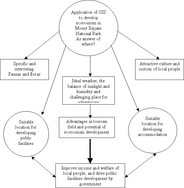
Until now, this area is not yet well managed-operated. To optimize the plan of Mount Rinjani National Park in ecotourism, GIS can be applied. Refer to many studies as stated above, GIS can identify which area that suitable for developing ecotourism and all of attractive aspects based on culture and custom around there.
The conceptual model can be design as advantages in interesting faunas and floras endemic, suitable weather, attractive custom and culture, and challenge place for adventure are believed can attract tourists to visit this place and directly also can improve the income of local people and government. On the other hand, tourism also related to facilities, so appropriate facilities to support tourism must be developed. In this term, the main point is how the development of facilities does not destroy the nature and placed in the best location. Moreover, quantity and type of facilities especially accommodation like hotel and guesthouse must be well planned.
The criteria of specialist accommodation adopted key characteristics of ecologically-sustainable accommodation suggested by Moscardo et al. (1996: 32) as follows:
· Small scale
· Locally owned (to maximise local economic benefits)
· Provides employment opportunities for the local community
· Provides other economic opportunities for the local community
· Spread throughout a region rather that clustered near major attractions
· Has a character, either through design or activities offered, that reflects the region
· Encourages protection of the heritage of a region through the use of existing and/or heritage buildings through providing interpretive or educational opportunities for guests through encouraging guests to engage in sustainable activities by minimising adverse biophysical impacts
· Does not adversely impact on other industries or activities
· Provides a quality experience for guests
· Must be a successful business
In general, based on ecotourism definition Honey (1999) the criteria for selecting destination areas in Mount Rinjani National Park can be determined as:
1. Must be in remote natural areas, whether inhabited or uninhabited, AND
2. Usually under some kind of environmental protection at the national, international, communal, or private level AND
3. Must be accessible, even if it is only a pathway AND
4. Have specific natural attractions, such as: water falls, scenic views and specific animals habitat OR
5. Have interesting traditional culture OR
6. Have challenging landscapes AND
7. Lay in minimal 600 meters above sea level
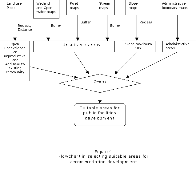
Criteria for selecting suitable location for developing public facilities, and suitable location for developing accommodation:
1. Not on the protected areas AND
2. Not on the water and wetland AND
3. Not on the productive land for example rice field AND
4. Maximum in 15% slope OR
5. Priority in open undeveloped areas OR
6. Priority in unproductive land OR
7. Priority put in areas adjacent to community with specific custom
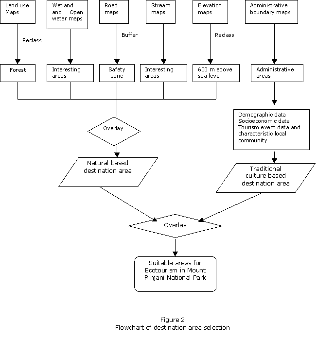
Refer to Joerger et al. (1999), Beedasy and Whyatt (1999), spatial data requirement in this system minimal as:
1. Land use maps scale 1:25.000
2. Wetland and open water maps scale 1:25.000
3. Road maps scale 1:25.000
4. Stream maps scale 1:25.000
5. Elevation and Slope maps scale 1:25.000
6. Administrative boundary maps scale 1:5.000
Attribute data:
1. Demographic data to determine composition of local people
2. Socio-economic data to determine the structure of community such as income class and education level class
3. Tourism event data for example the specific traditional custom of community and when it is held, around Mount Rinjani National Park
By combining those data, some analysis to answer the question about how to develop sustainable ecotourism in Mount Rinjani National Park can be done. There are many techniques can be applied in GIS implementation, such as Boolean analysis and weighted linear combination. According to Beedasy and Whyatt, Weighted linear combination has better scope for spatial decision-making and site selection. They said that weighted linear combination allows for the high performance of an alternative achieved on one or multi criteria to compensate for the weak performance of other criteria. However, as initial stage, this case use Boolean analysis technique in answers the problem.
The conceptual model of ecotourism in Mount Rinjani National Park can be visualized as below:
Figure 1
Conceptual Model of ecotourism in Mount Rinjani National Park
Flowchart of selecting destination areas
Flowchart of selecting suitable location for developing public facilities.

Public facilities include new roads network to improve accessibility to new destination area in national park, telecommunication infrastructure and health facilities.
Flowchart of selecting suitable location for accommodation development.
Based on Moscardo suggestion as mentioned before, attribute data is important to match the suitable location from GIS process and the real world. For example information where the location exactly support seven criteria that suggested by Moscardo must be surveyed directly from field.
Conclusion
The conceptual model and data model to develop one GIS for ecotourism planning are essential. From this model, what are the advantages, constraints, criteria and data required can be derived.
Based on literature review, to develop one GIS for ecotourism planning in Mount Rinjani National Park is feasible. Now it is depends on the real world, the availability of data required. Furthermore, the development and integration of GIS and associated technologies such as Global Positioning System, remote sensing and cartography play the important roles of improving decision making in tourism planning, by making information more accessible, valid, up to date, accurate and usable.
------------
References
Bahaire, T. and White, M.E., 1999, The Application of Geographical Information System (GIS) in Sustainable Tourism Planning: A Review, Journal of Sustainable Tourism, Vol.7:2: 159-174
Beedasy, J., and Whyatt, D., 1999, Diverting the Tourists: a Spatial Decision-Support System for Tourism Planning on a developing Island, JAG, Vol.1-Issue ¾:163-174
Burrough, P.A., 1986, Principles of Geographic Information System for Land Resources, Clarendon, Oxford
DoE, 1987, Report the Committee of Enquiry into the Handling of Geographic Data, HMSO, London
Grimshaw, D.J., 1993, Bringing GIS into Business Geoinformation, Longman, London
Honey, M., 1999, Ecotourism and Sustainable Development-Who Owns Paradise?, Island Press, Washington D.C.
Hunt, C., 1998, Year in Review 1998, Britannica Online Dictionary,
Available website http://www.britannica.com/bcom/eb/article/
Joerger, A., DeGloria, S.D., and Noden, M., 1999, Applying Geographic Information Systems: Sitting of Coastal Hotels, (email to Agustan, August 14, 2000) [Online]
Available email: agustan@oznet.net
Moscardo, G., Morrison, A.M., and Pearce, P.L., 1996, Specialist Accommodation and Ecologically Sustainable Tourism-Sustainable Tourism, The Journal of Sustainable Tourism, 4(1), 29 –52
Neisbitt, J., a, 1982, Megatrend, Ten New Directions Transforming Our Lives, Warner Books, Inc., New York
Sadler, 1990, (Quoted in Wight, P.A., 1993) Sustainable Ecotourism: Balancing economic, environmental and social goals within an ethical framework. Journal of Tourism Studies, 4(2), 54-64)
Scace, R.C., Grifone, E & Usher, R., 1992, Ecotourism in Canada, Canadian Environmental Advisory Council, Environment Canada, Quebec.
Widiyanti D., and Krishnayanti, I.K. (eds), 1999, Database Taman Nasional Indonesia, Konphalindo, Jakarta