|
|
|
|
|
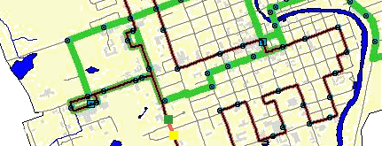
This project for the Technical Issues in GIS course, dealt with the challenge of creating
a GIS application to assist bus riders in the town of Lindsay, Ontario in finding the
quickest possible route from point A to point B. Using ArcView's Network Analyst to
create the application and data collection from the field, a reliable network was
created to give the user an accurate source of information regarding travel from stop
to stop. The end result provides the user with an application that can be used to
estimate the time that it takes to travel from start to destination.
Follow the link to view a
screenshot of the
application.
|
|
|
|