And know starts the good part...
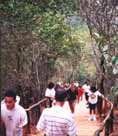
From the bifurcation, the path is a continuous slope, and very sunny. From time to time there are some places to rest under shadow, but they are very few.

The most critical point is a very long stairway (72 steps!) shown at left. If you're not fitted, give yourself all time you need.
Usually, this stairway is very crowded with people going up, going down, resting and almost dying. So, you'll see just in the middle part some benches at right.
When you reach the top and see backwards, this will be your view. If you look closely, you'll glimpse some tongues hanging out. :-)
Cheer up!. When stairway is done, you'll have walked about 70% of route. It still remains a tough part but it is not so step as this. Congratulate yourself!.
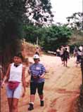
If you are taking it easy, about 30 minutes after bridge you'll be reaching Sabas Nieves. This point is at 1300 m above sea level (4260 ft), so you have conquered about 300 m (985 ft) from Cota Mil in about half hour. Not bad!. 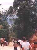
The first you'll find is a flat resting area at your left, where you can recover your breath and stretch.
Looking back, this is part the road you conquered, and note Caracas, far and bottom, between trees.
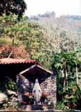
The ranger house is few more meters up, and also some benches, billboards, rest rooms and water!.
To get as map of this area, click here.
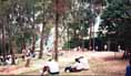
Beyond ranger house there is a bigger and shadowy area, with a good view of Caracas. There are only small ice creams to eat (Bs. 250), so you'd better bring your lunch.

If you're in the mood of going on, walk up through this resting area and at you'll find another bifurcation. If you turn left you'll get quickly to a higher resting area (Loma Serrano shelter).
This area is better for camping, because it is quieter. Some time ago, you needed special permission to put a tent on El Avila, but it is not required right now.
At the end of this zone there is a crossroad. The one at left leads to Quebrada Chacaíto, turn right and you'll return to Sabas Nieves, ant take the center path and you'll get to No Te Apures and Silla de Caracas. Distances from this point are as follow:
- La Silla: 4140 m (2.5 miles)
- Pico Oriental: 4710 m (2.85 miles)
- Pico Occidental: 5080 m (3 miles)
- Lagunazo: 6442 m (3.9 miles)

If you want to take a look at the road you just walked, click on this photo to get a perspective from Toma de Quintero.
 Editorial