|
[ The National Park Page | The Tent Page! ] |
|
Next national park site. Back to the National Park Page.
 |
 At the end of Hwy 180 is
  Cedar Grove which is a glacially carved valley much like Yosemite Valley. In fact, John Muir said Cedar Grove rivaled Yosemite in many ways. We got to experience some of the flood damage which happened in January 1997 along the Kings River up close as we had to travel right through the road construction on the way to Cedar Grove. The road has since been repaired and looks to be the same as it was before the flood. Cedar Grove has several excellent trails in the valley and it is also the starting point for many backcountry trips into the High Sierra Roads End has several large parking lots for backpackers wishing to experience the high country and we saw license plates from as far away as Massachusetts and Vermont. One of the eaiser trails took us over the Kings River and around Zumwalt Meadows which you can see a trace of in the picture above. I saw a Monarch butterfly in the meadow and learned from a ranger there are many milkweed plants (the principal food of the Monarch larvae) in the meadow. I believe this is the first time I have ever seen a Monarch.
 Probably one of the best aspects of this area of the park are the number of places where you can go down to the river and just sit and watch the water flow by. It is a very peaceful and tranquil location and worth looking into if you get the chance to visit.
 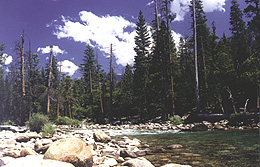 My sons tried unsuccessfully to rid the river bank in several areas of all of the rocks. Once they realized that was probably impossible in the time we had left in the park, they turned their attention to the pieces of driftwood along the bank. I'm sure several other people downstream probably wondered where all of the wood was coming from that floated by them that day.
|
This page was last updated on October 4, 2000
[ The National Park Page | The Tent Page! ] All photographs and written material on these pages, unless otherwise noted, are copyrighted © 1997 - 2000 by Webfoot. Do not copy or use without express written permission. The following advertisement is a GeoCities generated ad. Webfoot is not responsible for the content of such ads. Please address any complaints regarding these ads to Geocities and Yahoo or to the pages responsible for the content contained within them. I'm just trying to keep those stupid pop-up ads from showing up all over the place. |