| Back to Previous Page 返回前頁
Weekly Weather Report 每週天氣報告
Update Time 更新時間 Hong Kong Time 香港時間 17:20 15/10/2006 (Sunday 星期日)
|
| Back to Previous Page 返回前頁
Weekly Weather Report 每週天氣報告
Update Time 更新時間 Hong Kong Time 香港時間 17:20 15/10/2006 (Sunday 星期日)
|
| Summary Item 摘錄項目 | Value 數值 |
| Minimum Air Temperatures 最低氣溫 (oC) | 25.2 |
| Maximum Air Temperatures 最高氣溫 (oC) | 36.3 |
| Minimum Relative Humidity 最低相對濕度 (%) | 17 |
| Maximum Relative Humidity 最高相對濕度 (%) | 97 |
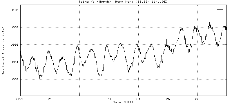
| Minimum Hourly Average Sea Level Pressure 最低每小時平均海平面氣壓 (hPa) | 1002 |
| Maximum Hourly Average Sea Level Pressure 最高每小時平均海平面氣壓 (hPa) | 1009 |
| Minimum 10-minute Average Sea Level Pressure 最低每10分鐘平均海平面氣壓 (hPa) | 1002.1 |
| Maximum 10-minute Average Sea Level Pressure 最高每10分鐘平均海平面氣壓 (hPa) | 1008.9 |
| Weekly Rainfall 本星期總雨量 (mm) | 89 |