KLR650
Rally - Moab - Page 4
The White Rim Trail - Mother of all trails - This is the
big one! We have all heard about this ride and anxious to get
going. We bought some lunch food, plenty of water and have checked
the maps and are ready to go! We were told that the best way to
ride the trail is counter clockwise. Something to do with a few
of the steep downhill sections of trail being easier. I could
not really tell which way it would have been best as there were
a few difficult places going in both directions! Heading north
again out of Moab we turned down the same highway 313 toward The
Island In The Sky Visitor Center but this time we turned off the
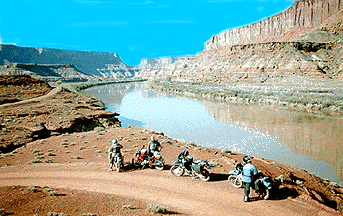
road onto a dirt road named Mineral Bottom Road.  This
will take you towards the Green River where you will descend down
to the river level and ride along for awhile as you hook into
the White Rim Trail. The road along this stretch is very easy
and wanders along for five or six miles following the Green river.
It will soon become apparent why it is called the Green River
- it looks green! It was a beautiful day! Clear blue sky and cool
temperatures, at least early in the morning. We departed Moab
around 7:00am and it was now about 8:00am as we followed the Green
River.
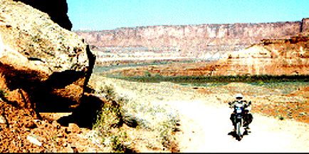
The elevation begins to climb after awhile and the trail
becomes less a 4wd trail and more of a bike trail. Some places
require a little effort to negotiate as the soil is rocky and
gets steep very fast as one climbs up and over the mesas. The
scenery is fantastic and around every turn one is met with greater
views and more spectacular scenery. We stop often for pictures. The trail is actually very busy as the mountain
bike crowd seems to be around every turn. We talked with a few
of them and found out they allow three to four days for them to
make the entire trail. The trail is about 105 miles from the Visitor
Center and back. They have chase vehicles behind them and camp
in one of the many National Park camp spots set up by the Park
Service. They look like they are in great pain when climbing the
steep hills but once on top they are all smiles and seem to find
this a great challenge. We continue riding through places with
names like "Potato Bottom Basin, Holeman Spring Basin, Turks
Pass, and Vertigo Void." I'm sure there are interesting stories
about all the names given to areas along the trail. The temperature
begins to climb rapidly as the morning goes on and it is easy
to understand why the Rangers and others in the local area recommend
carrying so much water! Two or three liters would be the minimum
I would carry. I drank all I had before we got back to Moab!
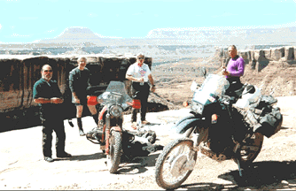
 We stopped for lunch around 11:00am
and enjoyed the view from a sheer drop-off. The picture on the
left was our lunch spot and it becomes apparent why this trail
is called the "White Rim trail!" Most of it follows
a series of canyons and the rock is white in color - very bright
and very rough to ride on. You can see the other side of this
particular canyon rim and notice how sharp they drop off! Riding
near the edge is a temptation but not for me-I don't like high
places! After lunch we checked the map and found we were only
about one third of the way around. We had plenty of day light
left and we decided to take our time but just not stop as often.
We still had some rough areas to negotiate so we began a little
longer ride between breaks. The group began to spread out some
as it was easier to ride the bad parts if we were not so grouped
up.
Previous Page | Top of Page | Next Page
First Page of the Article
Return to KLR Home
Page
 This
will take you towards the Green River where you will descend down
to the river level and ride along for awhile as you hook into
the White Rim Trail. The road along this stretch is very easy
and wanders along for five or six miles following the Green river.
It will soon become apparent why it is called the Green River
- it looks green! It was a beautiful day! Clear blue sky and cool
temperatures, at least early in the morning. We departed Moab
around 7:00am and it was now about 8:00am as we followed the Green
River.
 The trail is actually very busy as the mountain
bike crowd seems to be around every turn. We talked with a few
of them and found out they allow three to four days for them to
make the entire trail. The trail is about 105 miles from the Visitor
Center and back. They have chase vehicles behind them and camp
in one of the many National Park camp spots set up by the Park
Service. They look like they are in great pain when climbing the
steep hills but once on top they are all smiles and seem to find
this a great challenge. We continue riding through places with
names like "Potato Bottom Basin, Holeman Spring Basin, Turks
Pass, and Vertigo Void." I'm sure there are interesting stories
about all the names given to areas along the trail. The temperature
begins to climb rapidly as the morning goes on and it is easy
to understand why the Rangers and others in the local area recommend
carrying so much water! Two or three liters would be the minimum
I would carry. I drank all I had before we got back to Moab!
 We stopped for lunch around 11:00am
and enjoyed the view from a sheer drop-off. The picture on the
left was our lunch spot and it becomes apparent why this trail
is called the "White Rim trail!" Most of it follows
a series of canyons and the rock is white in color - very bright
and very rough to ride on. You can see the other side of this
particular canyon rim and notice how sharp they drop off! Riding
near the edge is a temptation but not for me-I don't like high
places! After lunch we checked the map and found we were only
about one third of the way around. We had plenty of day light
left and we decided to take our time but just not stop as often.
We still had some rough areas to negotiate so we began a little
longer ride between breaks. The group began to spread out some
as it was easier to ride the bad parts if we were not so grouped
up.