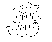
| In figure 1 the cooler air is falling toward the ground from beneath the cloud and displacing the warm air which is rising to replace the cool air. The warm air contains moisture and will rise above the cloud where it will be cooled because of high altitude temperature drop. The moisture laden cooled air will then start falling back toward the ground and either deposit some of the moisture into the original cloud or start forming another cloud depending on the prevailing wind. The air directly beneath the cloud is a downdraft and could possibly develop a Micro burst. The warm moist air that is rising on either side of the cloud are thermals and are a glider guiders delight. |
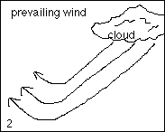
| In figure 2 we have the falling and rising air with a prevailing wind present. Note how the air movements are all at an angle. This is more representative of actual situations as the air masses we fly in usually have a little bit of wind in them. Try to remember that air is three dimensional and will move in all directions. It is hard to represent this on a piece of paper which is in two dimensions |
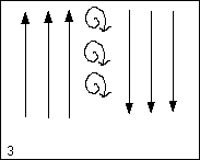
| Figure 3 represents air which is rising and falling along side one another and creating a swirling air mass between them. This is what creates wind shear. As said before, air will move in all directions, so this shear can be horizontal, vertical, or at any angle. All air movement, including wind shear can be any size from a few inches across to several miles. |
|
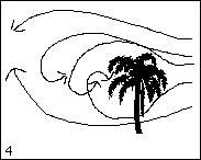
Figure 4 depicts air turbulence created by a solid object.
In this case, a tree. We experience all these air movements and
many more at MASH field. |